
Sothrieth
| Sothrieth | ||
.JPG) The Sothrieth near Oberohe |
||
| Data | ||
| location | Lower Saxony , Germany | |
| River system | Weser | |
| Drain over | Landwehrbach → Örtze → Aller → Weser → North Sea | |
| source | Northwest of Unterlüß 52 ° 51 ′ 49 ″ N , 10 ° 15 ′ 46 ″ E |
|
| Source height | 81 m above sea level NHN | |
| muzzle | south of Faßberg confluence with the Schmarbeck , forms the Landwehrbach coordinates: 52 ° 53 '23 " N , 10 ° 9' 49" E 52 ° 53 '23 " N , 10 ° 9' 49" E |
|
| Mouth height | 60 m above sea level NHN | |
| Height difference | 21 m | |
| Bottom slope | 2.6 ‰ | |
| length | 8.2 km | |
The Sothrieth is an 8.2 kilometer long stream in the Südheide ( Lower Saxony ).
Source and history
It forms in a pond area northwest of Unterlüß and flows, largely in natural, moist forest area, in a north-westerly direction past the Altensothrieth homestead . Here the stream used to be diverted to supply some fish ponds with water. However, these have long since silted up. A natural, swampy break forest has partially formed. The Sothrieth then cuts through the former kieselguhr mining area near Oberohe and Neuohe , flows through the villages of Niederohe and Gerdehaus, which are part of the Faßberg community, and joins the Schmarbeck to the Landwehrbach south of Faßberg , which flows into the Örtze after 2.8 km north of Müden .
The rare marsh calla (Calla palustris), which is classified in category 3 (endangered) on the red list of fern and flowering plants, grows on the banks of the stream.
history
.jpg)
In 1892, as part of the Uelzen – Celle field railway exercise, a railway line with a length of around 70 km was built for a narrow-gauge railway from Uelzen via Weesen to Celle . The purpose of the exercise was to find out how, in the event of war, material could be transported to the front on a narrow-gauge railway as quickly as possible. This route was chosen because there were few obstacles and the heath area was isolated. On the occasion of this exercise, a wooden bridge was built over the Sothrieth.
Water quality
Between Altensothrieth and Gerdehaus (here there is a campsite on the bank (currently closed)) and at the confluence with the Schmarbeck (here is the Faßberg sewage treatment plant), the Sothrieth only has water quality class II-III (critically polluted). Otherwise the stream has quality class II (moderately polluted).
Archaeological find
On a hill near the bank of the brook, a cremation grave , the so-called " Equestrian Grave of Hankenbostel ", was discovered in January 1900 when a sand pit was built .
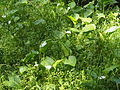
Marsh calla in the bank area
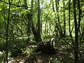
Bruchwald on the Sothrieth

Confluence of the Sothrieth (right) and Schmarbeck

.JPG)
