
Didderse
| coat of arms | Germany map | |
|---|---|---|

|
Coordinates: 52 ° 23 ' N , 10 ° 24' E |
|
| Basic data | ||
| State : | Lower Saxony | |
| County : | Gifhorn | |
| Joint municipality : | Papenteich | |
| Height : | 60 m above sea level NHN | |
| Area : | 7.41 km 2 | |
| Residents: | 1316 (Dec. 31, 2019) | |
| Population density : | 178 inhabitants per km 2 | |
| Postal code : | 38530 | |
| Area code : | 05373 | |
| License plate : | GF | |
| Community key : | 03 1 51 041 | |
| Address of the municipal administration: |
At the school 6 38530 Didderse |
|
| Website : | ||
| Mayor : | Randolf Moos ( SPD ) | |
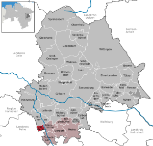
| Location of the municipality of Didderse in the district of Gifhorn | ||
  |
||


Didderse is a municipality in the Gifhorn district in Lower Saxony . It belongs to the combined municipality of Papenteich , which has its administrative seat in the municipality of Meine .
geography
location
Didderse lies between the Elm-Lappwald and Südheide nature parks on the Oker .
Neighboring communities
Didderse borders the following municipalities (clockwise, starting from the north):
- Hillerse , Adenbüttel , Wendeburg and Edemissen .
religion
The congregation is largely of Protestant denomination and, together with the villages of Hillerse, Rolfsbüttel and Neubrück, forms a parish .
population
| Didderse - population development since 1821 | ||||
|---|---|---|---|---|
| development | year | Residents | year | Residents |
 |
1821 | 356 | 1961 | 758 |
| 1871 | 394 | 1970 | 783 | |
| 1885 | 344 | 1980 | 797 | |
| 1925 | 621 | 1990 | 905 | |
| 1933 | 611 | 2000 | 1293 | |
| 1939 | 613 | 2015 | 1311 | |
| 1950 | 982 | 2016 | 1344 | |
|
as of December 31 of each year |
||||
history
Several prehistoric finds in the area of Didderse indicate a very early settlement activity. Several urn fields were located and bronze axes and individual urns were found.
The first written mention is dated to the year 780 AD. The document served the transfer of goods from Saxon nobles in several villages in the Liergau to the Fulda monastery. Didderse is mentioned as "Tideshusen" along with twenty other localities such as Schwülper . This makes Didderse one of the oldest villages in the Papenteich .
On March 1, 1974, the Didderse community lost its independence. It was awarded to the Wendeburg community in the Peine district together with the communities of Bortfeld , Harvesse , Meerdorf , Neubrück , Rüper, Sophiental and Wense . After the resistance of the population, the municipality of Didderse was rebuilt by hiving off from Wendeburg on May 1, 1981 and reorganized into the Gifhorn district. The layout of the new municipality does not exactly correspond to the extent of the former municipality of Didderse.
Since 2006, Didderse has been the only municipality in the joint municipality of Papenteich that was able to achieve freedom from debt.
Origin of the place name
Old names for Didderse are 780–802 Tid (er) eshusen, around 924 Ditenhusen, 1237 Thiddegessem, around 1250 Dhidikessen, 1272 Thidersen, 1281 Dhidegessen and 1311 Diderse. The place name has been subject to major changes in its history. Apparently it is a word formation with "-husen", perhaps most likely from the old "Tiad-her-es-husen". The personal name "Tiad-her" from the Germanic "Diut-her", from diut for "people" and harja for "army, warband".
Economy and Infrastructure
Mining
As early as 1906, test bores were carried out east of Didderse - towards Adenbüttel - to a depth of over 800 m. A potash mine was then built, which was in operation from 1912 to 1921. Remnants of the administration building can still be seen today.
traffic
Didderse is located north of the federal highway 2 , in the immediate vicinity of the federal highway 214 , which connects Braunschweig and Celle .
Public facilities
- School : The first mention of a school service in Didderse comes from the year 1636. From 1862 a regular school service was held in the Küsterhaus (today's parish hall). In 1928/29 a new school was built, which was expanded in 1959. The school service in Didderse was later completely stopped. Today the children and young people from the village attend the Adenbüttel primary school and secondary schools in Meine, Gifhorn and Braunschweig.
- Fire brigade and civil defense : The place had a vehicle sprayer since 1846. Initially, however, this was only carried out by the residents if necessary. The volunteer fire brigade was only founded in 1900 .
Sports
The SSV Didderse is responsible for sporting activities in Didderse. The SSV has soccer teams in almost every age group, gymnastics groups, a table tennis team and much more.
politics
Municipal council
The local council from Didderse consists of eleven council members and councilors.
(Status: local election on September 11, 2016)
mayor
The honorary mayor Randolf Moos was re-elected on November 15, 2016.
coat of arms
Blazon : “ Slanted left split; on top of a golden ground sprinkled with red hearts, a blue, upright, half-armored, red-armored lion with a red tongue, carrying a silver cornucopia pointing downwards; below on a red background a silver asparagus blossom . "
The Danish-Lüneburg lion is intended to commemorate the long membership of the Gifhorn district and the Lüneburg rule area. In contrast to the Brunswick lion, red hearts were scattered. The silver asparagus blossom symbolizes the asparagus cultivation, which is important for the village. The colors red and silver indicate the proximity and economic importance of the city of Braunschweig (city colors: red / silver).
Web links
Individual evidence
- ↑ State Office for Statistics Lower Saxony, LSN-Online regional database, Table 12411: Update of the population, as of December 31, 2019 ( help ).
- ↑ Papenteicher Nachrichten, issue 395, May 2007, p. 5
- ^ Federal Statistical Office (ed.): Historical municipality directory for the Federal Republic of Germany. Name, border and key number changes in municipalities, counties and administrative districts from May 27, 1970 to December 31, 1982 . W. Kohlhammer, Stuttgart / Mainz 1983, ISBN 3-17-003263-1 , p. 203, 268 .
- ^ Jürgen Udolph (research): The "place name researcher". In: website NDR 1 Lower Saxony . Archived from the original on January 26, 2016 ; accessed on August 3, 2019 .
- ↑ Renate Brand: Papenteich in old views. Eschenbach 1995, ISBN 3-89570-057-6 .
Adenbüttel | Bar wand | Bergfeld | Bokensdorf | Brome | Calberlah | Dedelstorf | Didderse | Ehra-Lessien | Gifhorn | Groß Oesingen | Hankensbüttel | Hillerse | Isenbüttel | Jembke | Leiferde | My | Meinersen | Tired (of all) | Obernholz | Osloß | Parsau | Ribbesbüttel | Rötgesbüttel | Rüh | Sassenburg | Schönewörde | Sultry | Sprakensehl | Steinhorst | Tappenbeck | Tiddish | Tülau | Numbers | Vordorf | Wagenhoff | Wahrenholz | Wasbüttel | Wesendorf | Weyhausen | Wittingen
Unparished area in Giforn Giebel county