
Papenteich municipality
| coat of arms | Germany map | |
|---|---|---|

|
Coordinates: 52 ° 23 ' N , 10 ° 32' E |
|
| Basic data | ||
| Existing period: | 1970– | |
| State : | Lower Saxony | |
| County : | Gifhorn | |
| Area : | 110.85 km 2 | |
| Residents: | 24,522 (Dec. 31, 2019) | |
| Population density : | 221 inhabitants per km 2 | |
| License plate : | GF | |
| Association key : | 03 1 51 5406 | |
| Association structure: | 6 municipalities | |
| Association administration address : |
Hauptstrasse 15 38527 Meine |
|
| Website : | ||
|
Samtgemeinde- mayor : |
Ines Kielhorn (independent) | |
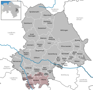
| Location of the joint municipality Papenteich in the district of Gifhorn | ||
  |
||

The joint municipality of Papenteich is a joint municipality in the Gifhorn district in Lower Saxony, immediately north of the city of Braunschweig .
geography
Geographical location
The integrated municipality of Papenteich is located on the Papenteich plateau between the Harz and the heath and connects to the north of the city of Braunschweig. The present day municipality extends over an area of 11083 ha, of which 14.3% is settlement and traffic area. The joint municipality of Papenteich is crossed centrally by the federal road 4 in a north-south direction . To the south in the direction of Braunschweig, the federal motorway 2 touches the municipality with the Braunschweig-Watenbüttel driveway and the Braunschweig-Nord motorway junction ( A2 / A391 ) just south of the municipality boundary . Larger cities in the vicinity are: Gifhorn , Wolfsburg , Braunschweig , Salzgitter , Wolfenbüttel , Peine and Celle .
Waters
At the southwestern end of the integrated community near Walle, the Schunter joins the Oker . These two rivers also represent the two largest rivers in the Samtgemeinde. There are also several smaller streams that have their source in the Samtgemeinde or that cross them on their way. These are the Bickgraben , the Rötgesbütteler Riede , the Vollbütteler Riede , the Rischmühlenriede (also called Gravenhorster Riede), the Horenriede and parts of the Hehlenriede . The watershed between the rivers Aller and Oker / Schunter is located within the municipality. This watershed runs from Flechtorf via Meinholz, Vordorf, Rethen towards Hillerse. Only the Bickgraben south of this divide flows into the Schunter, all other brooks flow into the Aller or the Allerkanal .
Joint community structure
The integrated municipality Papenteich was initially formed by 18 member municipalities on October 2nd, 1970. In the course of the territorial reform in 1974 there was a changed internal structure and a modified external delimitation. Part of the community reform was the amalgamation of various communities, in the course of which the current six communities emerged. In May 1981 the last change was the reorganization of the Didderse community, which had been separated off in 1974 . The integrated community today includes the member communities Adenbüttel , Didderse, Meine , Rötgesbüttel , Schwülper and Vordorf . The seat of the administration is mine.
| The 6 member communities with their associated districts and settlements | ||||
|---|---|---|---|---|
| local community | Residents (main residence) (31 Dec 2003) |
Area: in km² |
Density in population / km² |
Districts / settlements |
| Adenbüttel municipality | 1,724 | 13.71 | 126 | Adenbüttel , Rolfsbüttel , Gut Warxbüttel |
| Didderse municipality | 1,404 | 7.41 | 189 | Didderse |
| Congregation Mine | 8,070 | 38.73 | 207 | Abbesbüttel , Bechtsbüttel , Grassel , Gravenhorst , Meine, Meinholz , Martinsbüttel , Ohnhorst , Wedelheine , Wedesbüttel |
| Rötgesbüttel community | 2,280 | 10.83 | 211 | Rötgesbüttel |
| Schwülper community | 6,627 | 20.89 | 317 | Hülperode, Klein Schwülper, Lagesbüttel , Rothemühle, Groß Schwülper, Walle |
| Vordorf municipality | 3,326 | 19.26 | 173 | Eickhorst , Rethen , Vordorf |
Demographic data
| year | Residents | Apartments | year | Residents | Apartments | |
|---|---|---|---|---|---|---|
| 1989 | 16509 | 6817 | 2002 | 22852 | 9053 | |
| 1996 | 19945 | unknown | 2003 | 23069 | 9221 | |
| 1999 | 21357 | 8345 | 2004 | 23166 | 9418 | |
| 2000 | 22022 | 8665 | 2005 | 23448 | 9550 | |
| 2001 | 22361 | 8907 | 2013 | 23748 | unknown |
According to the Lower Saxony State Office for Statistics , in 2005 23,448 people lived in the combined municipality of Papenteich in 6,742 buildings with a total of 9,550 apartments with an average living space of 46.3 m per person. Since the establishment of the joint municipality, the number of inhabitants has grown steadily, both through positive natural population development and positive net migration. 22.60% of the population were under 18 years old in 2005, 6.30% between 18 and 25, 30.50% between 25 and 45, 27.00% between 45 and 64, and 13.60% were 65 years old or older older. The unemployment rate averaged 7.7% (men: 6.2%, women: 9.7%). 7698 people regularly commute out of the integrated community, in 1547.
The designation of new building areas and a densification of the town center resulted in suburbanization during the 1990s. This was favored by the geographical location immediately north of the city of Braunschweig, the proximity to the industrial city of Wolfsburg and the close connection to the federal motorway 2 . According to model calculations, the population of the entire municipality of Papenteich will continue to grow in the coming decades due to these factors.
The apparently only slight increase in 2005–2013 is due to the “population decline” in the statistical adjustment in the context of the census. In fact, the trend continued from 1999–2005, mainly due to immigration (construction of new building areas).
history

The Samtgemeinde Papenteich has only existed in its current form since 1970. In that year 15 communities merged and formed the new Samtgemeinde Papenteich. The name Papenteich can be traced back to medieval documents. The oldest forms of the name are poppendic or poppendyk . The first part probably refers to a Count Poppo who died in 1165.
The oldest trace of human life in the area of today's Papenteich is the megalithic grave found in 1995 near Rethen . According to investigations by the district archaeological office in Gifhorn, the grave is estimated to be around 3000 BC. Chr. Dated. However, this cannot be counted as a regular settlement of the Papenteich.
It is also proven that in prehistoric times there was a coherent, extensive forest area, the royal wild forest north forest , in the area of today's Papenteich . The Papenteich was criss-crossed and surrounded by several important medieval highways . Outside, on the one hand, a street ran from the Braunschweig Oker crossing to the Hamburg area, which followed the Oker course to the west, and on the other along the Schunter into the Altmark area . The Papenteich was crossed by the salt road running to Uelzen and Lüneburg , from which today's B4 was partly formed.
The settlement of the Samtgemeinde area known today took place in three phases. The oldest settlement group consists of the places Meine, Rethen, Stapel (wüst) and Vordorf, which were probably founded on a cleared island in the northern forest before the year 800 AD. Another group of place name endings are “-rode” and “-loh” in and around the Papenteich. The ending indicates a new foundation due to the shifting of settlement borders and the associated shifting of the clearing border . These villages were founded around the 9th century . The largest settlement group are the so-called " -büttel places". The area is sometimes referred to as the "bailiff". The linguistic research is derived from büttel from the North Saxon bodal . The youngest settlement group is seen as the villages with the place name ending “ -horst ”, which refer to a slightly elevated point in a swamp, moor or a damp lowland.
The political predecessor in Papenteich was the Grafschaft Papenteich, which was established in 1318. This was first given as a fief by Otto von Braunschweig to the Counts of Woldenberg before the princes of Lüneburg acquired the county of Papenteich in 1337 . In 1349/50 the great plague also occurred in the Braunschweig area , which raged badly in the Papenteich.
The Gogräfschaften Papenteich, which existed until 1852, are considered to be the oldest administrative structure in the Papenteich . The historical settlement areas referred to as Papenteich were almost twice as large in area as the present-day commune.
The last predecessor of the integrated municipality Papenteich was the Papenteich office, established in 1852. This was formed from the places of the Untergogräfschaft Papenteich.
Culture and sights
language
Papenteicher Platt
In the 19th century the daily slang was the Papenteicher Platt. This was partially documented in the German Language Atlas towards the end of the century . The Papenteich was considered a small dialect landscape in its own right within the East Westphalian Low German . A characteristic feature of this dialect is, among other things, the long ü instead of the otherwise long u in Low German : Üse Püdel is in a Tugt üt de Lüke rütesüset (our poodle whizzed out of the hatch in one go). Another dialect feature is, for example, that strangers older people of roughly the same social class are addressed not as gentlemen or women, but uncle and aunt . The church language, written and official language was standard German. The Papenteich dialect around 1900 is preserved in the newspaper articles by Karl Ahrens from Meine (1868–1937). For many years he wrote texts for the weekend supplement of the Gifhorner Aller newspaper .
As part of Low German as a recognized regional language, Papenteicher Platt is particularly protected under the European Charter for Regional and Minority Languages.
Heinrich Wesche , a scientist from Göttingen from Hillerse , tried to derive the settlement history of the Papenteich from the Papenteich Platt. The umlaut ü according to Papenteicher style can otherwise only be found in a similar form in Jutland , North Schleswig and Friesland . There are a few words except in the Papenteich only in North Schleswig. Probably a tribe from the north settled in the Papenteich in the 5th or 6th century, which is responsible for the unique agglomeration of -büttel place names. (The settlement geographer Wolfgang Meibeyer , on the other hand, assumes a significantly later date for the settlement period.)
During the 20th century, the local dialect declined dramatically. Around 2000 you hardly ever hear Papenteicher Platt in everyday situations, often only once or twice a year and therefore far less often than, for example, Italian, Turkish or Russian. The language is probably still completely mastered by a few hundred people, but many of them also speak Standard German in everyday life. The number of those who understand the dialect or occasionally use individual words and sentences is significantly higher. The dialect is still cultivated in cultural life, for example by the local author Karl-Otto Dohrendorf, by Low German working groups at the Meine elementary school and by events organized by the Samtgemeindebücherei. Since the dialect is currently only being passed on to children to a very limited extent, there is a possibility that it will die out in the 21st century.
Regional standard German
Although the Papenteich was recently strongly influenced by immigration (for example, the population of Meine has quadrupled since 1939), around half of the population speaks a more or less locally colored High German with Braunschweig and Papenteich elements, such as a so-called clear A and a soft G at the end of the word: Aantracht Braunschwaach stands for the Eintracht Braunschweig football club, for example . Around 200 Low German words are used in the otherwise high German colloquial language, but not all of them with the same frequency.
Attractions
Megalithic grave of Rethen
The megalithic grave of Rethen is a large stone grave found in 1995 , which dates back to around 3000 BC. . AD was dated. It is a disturbed system that was oriented in an east-west direction.
Economy and Infrastructure
traffic
In 1928 the Mittelland Canal was built through what was later to become the Samtgemeinde. The places Abbesbüttel, Wedelheine and Wedesbüttel are located directly on the canal. The long-distance cycle route Braunschweig-Lüneburg crosses the area of the Samtgemeinde in a south-north direction via Abbesbüttel, Meine, Ohnhorst and Gravenhorst, mostly on well-developed asphalt field paths away from motorized road traffic.
Road traffic
The entire municipality is opened up for road traffic in the north-south direction via the B 4 (Braunschweig-Lüneburg) and in the west-east direction via the L 321 (Peine-Wolfsburg). The previous lack of bypasses, the current population and traffic increase and, since January 2005, the use of the toll-free B 4 and L 321 by heavy goods traffic result in considerable burdens for the places crossed. The B 4 in Papenteich is also the most important traffic connection for the city of Gifhorn ( middle center ) and connects it with the A 2 and the city of Braunschweig ( upper center ). This results in the high volume of traffic on the B 4 in the Papenteich area of around 21,000 vehicles per day (as of 2000), including around 14-18% trucks (as of 2006). The discussion about traffic congestion, traffic calming and possible bypasses has long been a dominant topic of local politics. The extreme south of the municipality is touched by the A2 motorway near Schwülper and Walle.
Expansion and renovation of federal highway 4 in the Papenteich area
The district of Gifhorn is planning to redesign the B 4 in the area between Gifhorn and Braunschweig in coordination with the Lower Saxony Road Administration. The envisaged measures include relocating the route to bypass the localities of Meinholz , Meine , Rötgesbüttel and Ausbüttel as well as expanding it to four lanes. It is necessary to change the current situation due to the increasing volume of traffic (forecast 25,000 vehicles per day in 2015).
The Lower Saxony Road Administration carried out the first investigations into the relocation as early as 1990, but could not finish them because the State of Lower Saxony did not include the planning in its traffic route plan . In 1993 the district of Gifhorn took over the planning at its own expense and held a first application conference in 1994. In 2001 the planning was transferred to the Zweckverband Großraum Braunschweig , which initiated and published the spatial planning procedure in early 2002. After reviewing the total of 59 written submissions from different points of view, the regional planning determination was made in 2004, which designated a new route running east of Vordorf, west of Meine and east of Rötgesbüttel and Ausbüttel with a length of 13.9 km as the most space and environmentally friendly. Several citizens' initiatives had already dealt with the planning in advance. In Rötgesbüttel, a citizens' initiative called for the location to be bypassed. In Meine there were two groups with a large number of members: one was directed against a western bypass, the other against an eastern bypass of the place. About 600 citizens took part in the public discussion in Meine, a considerable number of Mein citizens also traveled to the deliberations of the regional authorities, for example the Gifhorn district council, to draw attention to their point of view there (with posters, among other things).
Rail transport

The Braunschweig – Wieren railway crosses the municipality in a north-south direction parallel to federal highway 4. There is one stop each in Meine and in Rötgesbüttel. In the planning of the RegioStadtBahn Braunschweig the service of the stops Meine and Rötgesbüttel by the lines S1 ( Uelzen - Bad Harzburg ), S2 ( Meine - Schöppenstedt ) and S10 ( Sassenburg-Triangel - Goslar ) was planned.
education
Schools have existed in the various communities and districts (for example: Rethen ) for centuries. In the 20th century, however, there was an ever increasing concentration on a few school locations, which was reinforced by the construction of the Meine school center in the 1960s. Only since the mid-1990s has a reversal of this trend become apparent with the construction of new schools in other communities (Schwülper, Adenbüttel). Secondary schools were the Meine Realschule, located in the Meine school center, as well as the Meine Hauptschule with the Groß Schwülper branch office for grades 5 and 6. With the reorganization of the school landscape in Papenteich, a new high school was built and a high school was founded in Groß Schwülper, which included the former Realschule and Hauptschule in united. This high school and the primary schools are run by the municipality.
For many decades there has also been a discussion about establishing a grammar school as the third grammar school in the Gifhorn district in Papenteich. This was finally built with the support of the regional church and the district of Gifhorn as a church evangelical grammar school in Meine , in the buildings of the former secondary school, secondary school and orientation level, under the name of Philipp Melanchthon grammar school . Furthermore, many students go to the Lessing-Gymnasium in Braunschweig-Wenden, but sometimes also to other grammar schools and comprehensive schools in Braunschweig or to the grammar schools in Gifhorn.
| Locations of the educational institutions within the combined municipality | ||||
|---|---|---|---|---|
| local community | Kindergartens | Elementary schools | High school | high school |
| Adenbüttel | Adenbüttel | Adenbüttel | ||
| Didderse | Didderse | |||
| My | Abbesbüttel, Grassel ( Grasselbande ), Meine ( Kita-Zellbergstraße, old outdoor pool ), Wedesbüttel ( Villa Kunterbunt ) | My | Philipp Melanchthon High School | |
| Rötgesbüttel | Rötgesbüttel | Rötgesbüttel | ||
| Sultry | Lagesbüttel, Rothemühle, Groß Schwülper, Walle | Big muggy | OBS Papenteich | |
| Vordorf | Rethen, Vordorf | Vordorf ( Margret and Rolf Rettich School) | ||
politics

Joint council
Since the local elections on September 10, 2006, the Samtgemeinderat has been composed as follows:
- CDU 42.27%, 15 seats
- SPD 44.61%, 15 seats (−1)
- Green 7.47%, 3 seats (+1)
- FDP 3.95%, 1 seat
- ALP 0 seats (−1)
Turnout : 59.90% (2001: 63.4%) In the Samtgemeinderat the SPD, Greens and FDP formed a joint parliamentary group under the name “Ampelgruppe”, which alludes to the colors of these parties (red-yellow-green). This traffic light group represented the majority in the Council and existed from 1986 to 2011.
The local election of September 11, 2011 brought a victory for the SPD and the Greens. With a turnout of 59.57%, it had the following result:
- SPD 49.60%, 17 seats (+2)
- CDU 33.25%, 11 seats (−4)
- Green 12.30%, 4 seats (+1)
- Pirate Party 3.47%, 1 seat (+1)
- FDP 1.38%, 1 seat
The first meeting of the newly elected council took place in November 2011. The following groups and parliamentary groups now exist:
- SPD / FDP: 18 seats,
- CDU: 11 seats,
- GrüPi (Greens and Pirates): 5 seats.
After the local elections on September 11, 2016 (voter turnout 64.27%), the following ratios emerged in the council:
- SPD 35.57%, 12 seats (−5)
- CDU 26.39%, 9 seats (−2)
- WGP (voter group) 21.04%, 7 seats (+7)
- Green 12.72%, 4 seats (± 0)
- FDP 2.24%, 1 seat (± 0)
- The Left 2.04%, 1 seat (+1)
Joint mayor of the municipality
Until 2004, the mayor of the joint municipality was active on a voluntary basis and was elected by the majority of the joint municipality during the constituent meeting.
Today the mayor of the joint community works full-time and is directly elected by the persons entitled to vote in the joint community. The applicant must achieve the majority of the votes cast , if necessary by means of a runoff . In addition, the mayor assumes the duties of a joint municipality director and heads the joint municipality administration and is responsible for all business operations and administrative activities. The first full-time joint mayor has been Helmut Holzapfel (SPD) since January 1, 2005, re-elected in 2011. His successor was determined in a new election in the context of the local elections in September 2016 with the election of Ines Kielhorn (non-party).
New election of the mayor of the municipality in 2016
On September 11, 2016, the citizens were called upon to elect the new joint mayor by direct election . Incumbent Helmut Holzapfel did not run again due to age.
In a general meeting of the Papenteich local association on March 2, 2016, the Greens unanimously approved Dr. Arne Duncker (Meine) nominated as her candidate. The SPD candidate, Stefan Konrad, was determined on March 18, 2016 by a joint party meeting of the various Papenteich SPD local associations. This meeting had to choose between the candidates Stefan Konrad (Rötgesbüttel) and Ines Kielhorn (Meine). Alexander Jankowski was chosen as the candidate of the CDU. Ines Kielhorn also entered now without party.
Since none of the candidates achieved an absolute majority in this election, there was a runoff on September 25, 2016, which the non-party applicant Ines Kielhorn (33.6%) won against the SPD candidate Stefan Konrad (29.8%) .
coat of arms
Blazon : Divided by red and gold, under a red shield head, inside a blue armored lion turned to the left; At the bottom in the base of the shield a blue rafter, embedded beneath it is a red heraldic rose with green petals and gold stamps laid on a black wall anchor cross. In the top right corner a stylized green plow iron, on the left an upright red ax.
The lion in the coat of arms symbolizes the former affiliation of the entire present-day community to the Guelph dukes of the Duchy of Lüneburg . The stylized rose represents the blossoming villages and communities of the integrated community, which have come together to perform common tasks under the umbrella of the integrated community - the rafters. The previously predominant agricultural activity of the entire community population is symbolized by the plow. The ax reminds of the old Grafschaft Papenteich and its own jurisdiction - the blood court - at the old "Dingstätte".
Community partnerships
Personalities
- Uwe-Peter Lestin (* 1943), 1991 to 2001 mayor of the municipality, from 1998 to 2008 member of the Lower Saxony state parliament
- Georg Burchard Strauss (around 1584–1632), founder of the Lower Saxon noble house "Strauss and Torney"
- Rolf Rettich (1929–2009), illustrator of children's books
literature
- C. Brandt: Schwülper. A piece of Lower Saxony's local history. Hildesheim 1912.
- Gerhard Oberbeck: The medieval cultural landscape of the area around Gifhorn. Bremen-Horn 1957.
- Lower Saxony State Administration Office (ed.): The district of Gifhorn. In: The districts in Gifhorn. Volume 26. Bremen 1972, ISBN 3-87172-327-4 .
- History from the Papenteich . Edited by Heinz Klose. Mine 1983, ISBN 3-87040-029-3 . Numerous essays and short articles, especially on the history of Papenteich.
- Heinz Klose: History from the Papenteich . Mine 1983, ISBN 3-87040-029-3 ; Numerous essays and short articles, especially on the history of Papenteich.
- Wolfgang Meibeyer: Settlement history about the Papenteich and the question of its -büttel-places - The settlement of the old northern forest between Gifhorn and Braunschweig during the early Middle Ages . In: Series of publications by the district of Gifhorn. No. 22, 2nd edition. District of Gifhorn and Museum and Heimatverein Gifhorn e. V., Gifhorn 2004, ISBN 3-929632-70-5 .
- Stephan Bitter, Hans-Heinrich Gurland (Ed.): Invisible Church . Rheinbach 1999, ISBN 3-87062-034-X . (therein pp. 100–309: Diaries of Meiner Evangelical Parish Pastor Rudolf Gurland 1930–1939. The pastor was persecuted by the National Socialists because of his Jewish descent).
- Papenteich in old views (illustrated book with 228 pages). Geiger-Verlag, Horb am Neckar 1995, ISBN 3-89570-057-6 .
- The Papenteicher Nachrichten has been an official newsletter since the Samtgemeinde was founded . Issue 391 from January 2006 appeared in an edition of 10150 copies and a length of 56 pages. The content of the “Nachrichten” has always gone far beyond mere official communications: there are also diverse club communications, reports, literary texts, and results of local history research.
Web links
- Website of the Samtgemeinde Papenteich
- Municipal location information system for SG Papenteich
- Historic Papenteich
Individual evidence
- ↑ State Office for Statistics Lower Saxony, LSN-Online regional database, Table 12411: Update of the population, as of December 31, 2019 ( help ).
- ↑ a b IHK Braunschweig: Regional Report 2006 ( Memento of the original of July 10, 2007 in the Internet Archive ) Info: The archive link was inserted automatically and has not yet been checked. Please check the original and archive link according to the instructions and then remove this notice. (PDF)
- ↑ Contribution to the research project City 2030 (PDF; 4.9 MB)
- ^ Bevenroder history ( Memento from August 2, 2003 in the Internet Archive )
- ^ History of the Gifhorn District Court
- ↑ The large stone grave in Rethen ( Memento of the original from October 8, 2007 in the Internet Archive ) Info: The archive link was inserted automatically and has not yet been checked. Please check the original and archive link according to the instructions and then remove this notice.
- ^ ZGB : Regional planning for the relocation of the B4 in the area between Braunschweig and Gifhorn (PDF; 1.9 MB)
- ↑ Wolfsburger Allgemeine Zeitung, Aller Zeitung, W: Samtgemeinde Papenteich - runoff election: Ines Kielhorn is mayor - WAZ / AZ-online.de. In: waz-online.de. September 25, 2016, accessed December 18, 2016 .
Boldecker Land | Brome | Hankensbüttel | Isenbüttel | Meinersen | Papenteich | Wesendorf