Bechtsbüttel
|
Bechtsbüttel
Congregation Mine
Coordinates: 52 ° 20 ′ 24 ″ N , 10 ° 32 ′ 25 ″ E
|
|
|---|---|
| Height : | 77 (75-81) m |
| Residents : | 568 (Dec. 31, 2013) |
| Incorporation : | March 1, 1974 |
| Postal code : | 38527 |
| Area code : | 05307 |
|
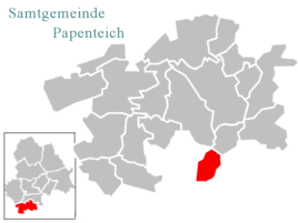
Location of Bechtsbüttel in the joint municipality of Papenteich
|
|
|
Bechtsbüttel, outskirts
|
|
Bechtsbüttel is a district of the municipality of Meine in Lower Saxony, immediately north of Braunschweig .
geography
Geographical location
Bechtsbüttel is located in the south of the Gifhorn district and borders the city of Braunschweig on three sides . Only a narrow connection to Abbesbüttel leads over the Gifhorn area. The Mittelland Canal and the Braunschweig – Wieren railway line run in sections through the Bechtsbüttel district . Bechtsbüttel is part of the community of Meine and is located about five kilometers as the crow flies south-southeast of the main town. The closest medium- sized centers are Wolfsburg , Salzgitter , Wolfenbüttel , Gifhorn , Peine and Celle .
Neighboring communities
* Distances refer to the distance to the city center.
| City of Gifhorn (20 km) | ||||
| Community of Vordorf (3.5 km) | District of Meine (5 km) | Abbesbüttel district (2 km) | City of Wolfsburg (30 km) | |
| BS-Thune (2 km) |

|
District Grassel (4 km) | ||
| BS-Wenden (2.5 km) | BS-Bienrode (2 km) | BS-Waggum (1.5 km) | ||
| City of Braunschweig (10 km) |
population
| year | Residents | Houses | year | Residents | Houses | |
|---|---|---|---|---|---|---|
| 17th century | 3 | 1939 | 250 | |||
| 18th century | 40-50 | 1950 | 462 | 50 | ||
| 1811 | 117 | 13 | 1961 | 443 | ||
| ~ 1850 | 146 | 1970 | 439 | |||
| 1895 | ~ 50 | 1980 | 416 | |||
| 1905 | 194 | 1990 | 419 | |||
| 1912 | 193 | 2000 | 531 | |||
| 1933 | 245 | 2014 | 568 |
The population development in historical time is documented for Bechtsbüttel independently of the community of Meine. Since the incorporation and the establishment of the joint municipality in 1974, the population development for the place Bechtsbüttel has been documented by the joint municipality Papenteich . As of December 31, 2006, Bechtsbüttel had 534 inhabitants, currently increasing to 568 inhabitants.
There are no known data on the number of inhabitants about the early days of the place. In the 18th century the population of Bechtsbüttel was no more than forty to fifty people. In 1811 117 people were counted, including the small settlement of Wendebrück. The next significant increases came with the construction of the railway in 1894 and the construction of the Mittelland Canal in the early 1930s . During the post-war period, the number of inhabitants rose to 462 due to the influx of refugees and displaced persons. Until the municipal reform in 1974, Wendebrück was also part of Bechtsbüttel.
history
Foundation of Bechtsbüttel
Bechtsbüttel is one of the villages that end in -büttel and the exact time it was founded is controversial. The latest publications assume a founding phase in the 11th to the 15th century. Bechtsbüttel is first mentioned in 1196 as Berthisbutl in the deed of Heinrich zu Rhein , the eldest son of Heinrich the Lion . According to this document, the village belonged to the St. Cyriakus monastery . In 1418 the village was transferred to the Riddagshausen monastery , to which it was subject to interest until the 19th century. In the deed of ownership, however, the place is described as a "desolate village" so that it can be assumed that the place had fallen desolate and was repopulated at a later date. However, there are no precise documents about these dates. During the renaturation of the Beberbach, an old boundary stone was found on the southern edge of Bechtsbüttel, which demarcated the Duchy of Braunschweig from the Kingdom of Hanover. There are other stones on the Waggum – Abbesbüttel cycle path, which runs east along the gravel pit, and south of the Bockelsberg on the edge of the Bechtsbütteler Krühgarten. A historical description of the boundary can be found in the 1824 recession.
Incorporation
On March 1, 1974, Bechtsbüttel was incorporated into the community of Meine. Part of the place was reclassified to Braunschweig.
Culture and sights
societies
The village has a community center. The following associations and organizations are also located in Bechtsbüttel:
- Bechtsbüttel volunteer fire brigade from 1932
- Schützenverein Bechtsbüttel from 1951 e. V.
- Bechtsbüttel Settler Community from 1955 ( German Settlers Association )
- Sports club "Turm 78"
- Gardener's Association Bechtsbüttel
- Women's Aid Bechtsbüttel
- Bechtsbüttel hunting association
- Youth club Bechtsbüttel (supervised by a freelance worker from the Meine community)
traffic
The Wenden-Bechtsbüttel depot is on the Braunschweig – Wieren railway line . Trains can cross here .
Web links
swell
- ^ Brand, Renate: Papenteich in old views , Eschenbach 1995, ISBN 3-89570-057-6
- ^ Administrative history of Gifhorn up to 1939 ( Memento from February 28, 2007 in the Internet Archive )
- ↑ a b Papenteicher Nachrichten, issue 395 - May 2007, page 5
- ↑ http://www.bechtsbuettel.de
- ↑ Nouveau recueil de traités d'alliance, de paix, de treve, de ..., Volume 6
- ^ Federal Statistical Office (ed.): Historical municipality directory for the Federal Republic of Germany. Name, border and key number changes in municipalities, counties and administrative districts from May 27, 1970 to December 31, 1982 . W. Kohlhammer GmbH, Stuttgart and Mainz 1983, ISBN 3-17-003263-1 , p. 226 and 267 .


