All channel
| All channel | ||
|
Course of the universal canal |
||
| Data | ||
| Water code | EN : 4818 | |
| location | Germany ( Lower Saxony ) | |
| River system | Weser | |
| Drain over | Aller → Weser → North Sea | |
| Branch from the Aller | South of Weyhausen 52 ° 27 ′ 5 ″ N , 10 ° 43 ′ 31 ″ E |
|
| Source height | 55 m above sea level NHN | |
| muzzle | Brenneckenbrück west of Gifhorn Coordinates: 52 ° 28 ′ 40 " N , 10 ° 27 ′ 56" E 52 ° 28 ′ 40 " N , 10 ° 27 ′ 56" E |
|
| Mouth height | 50 m above sea level NHN | |
| Height difference | 5 m | |
| Bottom slope | 0.26 ‰ | |
| length | 19.5 km | |
| Catchment area | 202.78 km² | |
| Left tributaries | Mühlenriede , Hehlenriede , Rötgesbütteler Riede , Vollbütteler Riede | |
| Medium-sized cities | Gifhorn | |
| Water body NLWKN : 14046 | ||
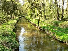
The Allerkanal is an artificially created body of water in Lower Saxony in the middle of the 19th century . The almost 20 km long canal runs between Wolfsburg and Gifhorn . It serves to protect agricultural areas against floods of the Aller . The almost dead straight canal drains the water of the Aller faster than it is possible for the river in its strongly meandering course in this section of the Aller glacial valley .
course
The Allerkanal, completed in 1863 after three years of construction, branches off at Weyhausen just behind the city of Wolfsburg and the tributary of the Kleine Aller from the Aller. This turns to the north, while the canal leads almost dead straight westwards through the Barnbruch wetland to Gifhorn. Directly behind the Barnbruch near Osloß , the Allerkanal is crossed by the Elbe Lateral Canal in a trough bridge. After the bridge was built, it was looped under it in a small loop.
It passes the town of Gifhorn to the south and, to the west of the town, from the Winkel district onwards, uses the expanded and widened stream bed of the Hehlenriede , which formerly opened there from the south , the rest of which is now called the Alte Hehlenriede . The course of the canal is correspondingly more bendy and turns to the north. Five kilometers downstream, the canal flows into the Aller west of Gifhorn near Brenneckenbrück on the B 188 . About a kilometer upstream the canal was dammed by a weir , which has since been replaced by a bed slide . The Aller flows parallel a few kilometers north of the canal and forms narrow river loops in this flat area of its glacial valley, which naturally reduce the flow rate.
construction

The construction of the Allerkanal between 1860 and 1863 was preceded by a state treaty between Prussia , Hanover and Braunschweig on the regulation of the Aller. The purpose was to regulate the spring floods of the Aller and to contribute to the drainage of the former marshland of the Barnbruch. The canal is about 5 meters wide and 1 meter deep. Since the builders had hardly any technical aids at the time, workers dug it up with shovels.
A memorial stone was erected on the canal between Brenneckenbrück and Gifhorn-Winkel. It bears the inscription:
- Allerkanal, built 1860-63, cost 45,000 Thaler, the farmers of the Allerdörfer from Wolfsburg to Diekhorst who created it, the hydraulic engineering inspector August Hess in Celle, who built it and the men who looked after it in memory
Water quality
The Lower Saxony water quality report from 2004 rated the chemical water pollution in the Aller canal as well as the Aller as a whole as moderately polluted (quality class II). The fact that the fascines have largely decayed as bank reinforcements, the canal has been transformed into a natural body of water. The canal runs through the deciduous forest area of the Barnbruch, so that it is shaded. This prevents the watercourse from becoming weed, which is the case in many places on the mostly unshaded Aller.
Tributaries
- All
- Old mill moat
- Mühlenriede
- Senator's Trench
- Hehlenriede
- Rötgesbütteler Riede over the Alte Hehlenriede
- Vollbütteler Riede over the Alte Hehlenriede
- Viehmoorgraben
- Wittesmoorgraben
Individual evidence
- ↑ a b State Office for Geoinformation and Land Surveying Lower Saxony: Top 50 - Topographic Map 1: 50,000 Lower Saxony / Bremen , as of 2000.
- ↑ a b NLWKN : Inventory of the implementation of the EU Water Framework Directive, processing area Aller / Quelle , Braunschweig November 2004, Appendix Table 3 listing of water bodies.
- ↑ Water quality report Aller / Quelle 2004 of the Lower Saxony State Office for Water Management, Coastal Protection and Nature Conservation
- ↑ Allerkanal water quality map

