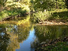
Mühlenriede
| Mühlenriede | ||
|
Stream shortly before the confluence with the Allerkanal |
||
| Data | ||
| Water code | DE : 48182 | |
| location | Wolfsburg , Papenteich | |
| River system | Weser | |
| Drain over | Allerkanal → Aller → Weser → North Sea | |
| source |
A 39 , Wolfsburg-Mörse 52 ° 23 ′ 10 ″ N , 10 ° 43 ′ 50 ″ E |
|
| Source height | 80 m above sea level NHN | |
| muzzle | at Tankumsee in the Allerkanal Coordinates: 52 ° 27 ′ 43 " N , 10 ° 36 ′ 29" E 52 ° 27 ′ 43 " N , 10 ° 36 ′ 29" E |
|
| Mouth height | 54 m above sea level NHN | |
| Height difference | 26 m | |
| Bottom slope | 1.5 ‰ | |
| length | 17.4 km | |
| Catchment area | 48.25 km² | |
| Big cities | Wolfsburg | |
| Medium-sized cities | Gifhorn | |
| Communities | Calberlah , Isenbuettel | |
The Mühlenriede is a brook on the northeastern edge of the Papenteich plateau with an approximately 50 km² catchment area west of the city of Wolfsburg and southeast of the city of Gifhorn . The brook belongs to the Aller river system . It flows into the Allerkanal not far from the Tankumsee .
topography
The brook arises in the west of the city of Wolfsburg. The source streams are now completely piped, so that their source and their upper reaches are no longer recognizable. The stream comes to the surface on the A 39 near the Wolfsburg districts of Mörse and Ehmen . On the southern outskirts of these two places the Mühlenriede initially flows westwards before it bends north on the western outskirts of Ehmen. The Mühlenriede flows past Fallersleben and then covers the Mittelland Canal at Sülfeld . After crossing under the canal, the stream turns northwest towards Calberlah . After the Mühlenriede has passed the village, it bends slightly north on the county road to the Kranichsmoor and covers the Elbe Lateral Canal . It is led in an artificially created bed southwest around the Tankumsee and reaches the Allerkanal in a relatively straight line .
Tributaries
The Klein Brunsroder Riede is a left source stream of the Mühlenriede. The stream rises north of Groß Brunsrode in Flechtorfer Holz. It feeds itself from several small springs and drains both the forest area and the surrounding arable land. The water had been well developed and straightened over a long period of time. The moat has not been maintained since the 1990s, so it is partially renatured. The stream flows through intensively used arable land and is only protected in a few places by wood on the banks. In addition, over the are receiving water a pond treatment plant the wastewater discharged into the creek.
Flora and fauna

The Mühlenriede is a largely developed and straightened body of water with very little water at times. Most of the stream runs through green areas and is only shaded by trees in a few areas. Today the stream is slowly developing back to its natural state, supported in parts by renaturation measures. The first renaturation measures were completed some time ago in the Auewiesen between Ehmen and Fallersleben. In 2004, the relocation of the river bed and renaturation began in the section between Mörse and Ehmen.
Running water organisms are largely absent in the Mühlenriede. Nevertheless, there are nine animal species that are on the Red List of Lower Saxony:
- a kind of mayflies - Siphlonuridae armatus
- two different species of caddis flies
- two different types of long-button water beetles
- a subspecies of the bladder snail
- a subspecies of the clamshells
- the banded demoiselle
- the blue feather dragonfly
Water quality
As is usual in the Lüneburg Heath, the bottom of the water consists of sand and fine gravel. The Lower Saxony water quality report from 2004 rated the chemical water pollution of the Mühlenriede in the upper and middle reaches as moderately polluted (quality class II). The underflow is critically polluted (quality class II-III).
literature
- Eberhard Sprenger: The Mühlenriede yesterday and today - a historical consideration. BUND brochure
Individual evidence
- ↑ a b State Office for Geoinformation and Land Surveying Lower Saxony: Top 50 - Topographic Map 1: 50,000 Lower Saxony / Bremen , as of 2000.
- ↑ a b NLWKN : Inventory for the implementation of the EU Water Framework Directive, surface waters processing area Aller / Quelle , Braunschweig 2004, Appendix Table 03 listing water bodies .
- ↑ Water quality report Aller / Quelle 2004 of the Lower Saxony State Office for Water Management, Coastal Protection and Nature Conservation
Web links
- Water quality report Aller / Source 2004 of the State of Lower Saxony (PDF, 1 MB)
- Renaturation of the Mühlenriede - sponsorship of the Fallersleben high school in Wolfsburg-Fallersleben
- Mühlenriede renaturation on the website of the BUND district group Wolfsburg
- BUND district group Wolfsburg celebrates stream renaturation - report in BUND magazine


