Brechtorf
|
Brechtorf
Municipality of Rüben
|
||
|---|---|---|
| Coordinates: 52 ° 28 ′ 43 ″ N , 10 ° 52 ′ 35 ″ E | ||
| Height : | 68 m above sea level NN | |
| Residents : | 1170 (Dec. 31, 2019) | |
| Incorporation : | July 1, 1972 | |
| Postal code : | 38471 | |
| Area code : | 05367 | |
|
Location of Brechtorf in Lower Saxony |
||
|
Brechtorf from the south, on the right the tower of the former school
|
||
Brechtorf is a district of the municipality of Rüsten in the east of the Lower Saxony district of Gifhorn .
geography
The place Brechtorf lies on the Vorsfelder Werder not far from the low moor area Drömling . It is also in close proximity to the city of Wolfsburg . The neighboring district of Wolfsburg is Wendschott . Wippermühle, which belongs to Wolfsburg, is located directly on the southern border of Brechtorf . One kilometer north of Brechtorf is Rorien, two kilometers west of Eischott , which also belongs to the municipality of Rorien. In the east, the Mittelland Canal runs less than a kilometer away .
The Wipperteich , once the largest lake in the Duchy of Braunschweig , used to be between Brechtorf, Eischott and Velstove .
history
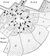
Brechtorf was first mentioned in 1150 as Bracthorpe . At that time the village was owned by the Sankt Ludgeri monastery in Helmstedt . In 1224 it was referred to as Bracktorp in another document . The name probably means "village at the small ford", the first syllable coming from Slavic . Until the 18th century the place had the shape of a round . The place grew especially after the Second World War . Employees from the Volkswagen factory in Wolfsburg have been moving here since then . On July 1, 1972, Brechtorf and Eischott were incorporated into the municipality of Rorien, which in turn became the seat of the newly founded joint municipality of Rorien . At the same time, the communities of the integrated community changed from the Helmstedt district to the Gifhorn district. Two years later, the joint municipality of Rüßen was merged into the joint municipality of Brome . In 2000, the 850th anniversary celebration took place with numerous activities. In December 2019, Brechtorf had 1170 inhabitants.
economy
In addition to a few handicraft businesses and other traders, there was a design office for special machines in Brechtorf. Retail businesses are located in the nearby Rüllen. Agriculture is still practiced on a small scale. 1985 there were nine agricultural commercial farms .
Churches
The Evangelical Lutheran parish of Brechtorf-Eischott is part of a parish association with the Evangelical Lutheran parishes of Rorien and Parsau ( parish association ) and is looked after by the parish office of Rorien. Until the 1950s, due to the lack of a church of its own, there was a close connection between church life and St. Petrus Church in Vorsfelde (now a part of Wolfsburg), where regular church services as well as baptisms, confirmations and weddings took place. During this time, services were occasionally held in the Brechtorf school. The St. Markus Church in Brechtorf was built by Friedrich Berndt from 1957 to 1958 and then consecrated as a house of worship for the parishes of Brechtorf and Eischott at the time. In 2003 the church building was expanded to include an extension with community rooms.
coat of arms
- Origin:
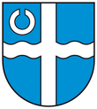
As a supplement to the common coat of arms of the municipality of Rühren , a citizens' assembly decided on August 23, 1989 for its own coat of arms, which was drawn up by the Brunswick heraldist Arnold Rabbow.
- Description:
The coat of arms shows a continuous silver or white cross in a blue shield , the horizontal arms of which are wave-shaped and which is accompanied by a white circular symbol in the front upper corner .
traffic
Brechtorf is located on the Rüsten road to Wolfsburg. A bypass road completed in 2003 leads directly to the center of Wolfsburg without having to cross the eastern parts of the city. A county road leads towards Eischott. Thanks to the Wolfsburg – Brome bus line , there are hourly, otherwise every two-hour trips in both directions on weekdays. Additional trips are offered on weekdays on the Wolfsburg – Rühren line.
literature
- Johann Dietrich Bödeker: The land of Brome and the upper Vorsfelder Werder, history of the area at Ohre, Drömling and Kleiner Aller. Braunschweig 1985, ISBN 3-87884-028-4 , pp. 574-598.
- Günter Barthel among others: Rorien, Brechtorf and Eischott in pictures. Horb am Neckar 2004, ISBN 3-89570-929-8 .
- Working group 850 years Brechtorf, festival committee: 850 years Brechtorf 1150–2000. Brechtorf 2000.
Individual evidence
- ^ Federal Statistical Office (ed.): Historical municipality directory for the Federal Republic of Germany. Name, border and key number changes in municipalities, counties and administrative districts from May 27, 1970 to December 31, 1982 . W. Kohlhammer GmbH, Stuttgart and Mainz 1983, ISBN 3-17-003263-1 , p. 271 .
- ↑ Bulletin of the Samtgemeinde Brome from January 31, 2020; Counting of the total municipality
- ^ Ernst Pauer: Church history and church art. In: Historical-regional excursion map of Lower Saxony, sheet Wolfsburg. Erhard Kühlhorn, Hildesheim 1977, ISBN 3-7848-3626-7 , explanatory booklet p. 120.


