
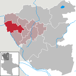
Diesdorf
| coat of arms | Germany map | |
|---|---|---|

|
Coordinates: 52 ° 45 ' N , 10 ° 53' E |
|
| Basic data | ||
| State : | Saxony-Anhalt | |
| County : | Altmarkkreis Salzwedel | |
| Association municipality : | Beetzendorf-Diesdorf | |
| Height : | 56 m above sea level NHN | |
| Area : | 100.51 km 2 | |
| Residents: | 2295 (Dec. 31, 2019) | |
| Population density : | 23 inhabitants per km 2 | |
| Postal code : | 29413 | |
| Area code : | 03902 | |
| License plate : | SAW, GA, KLZ | |
| Community key : | 15 0 81 105 | |
| Association administration address: | Marschweg 3 38489 Beetzendorf |
|
| Website : | ||
| Mayor : | Fritz Kloß | |
| Location of Diesdorf in the Altmarkkreis Salzwedel | ||
  |
||

The Flecken Diesdorf is a municipality in the Altmarkkreis Salzwedel in Saxony-Anhalt .
geography
The place is located in the western Altmark and is characterized by a gently rolling terminal moraine landscape with mostly forested barren sandy soils, largely shaped by the Saale Ice Age.
This village is located about 25 km southwest of Salzwedel. In the immediately neighboring Lower Saxony , the next larger town Wittingen is about ten kilometers away.
Community structure
The community has the following districts and places to live:
|
|
climate
The annual precipitation is 622 mm. The rainfall is low. They are in the lower quarter of the values recorded in Germany. Lower values are registered at 25% of the measuring stations of the German Weather Service . The driest month is October, the most precipitation falls in August. In August there is 1.6 times more rainfall than in October. Precipitation varies only minimally and is extremely evenly distributed over the year. Lower seasonal fluctuations are recorded at only 4% of the measuring stations .
history


The megalithic graves near Schadewohl and the megalithic graves near Diesdorf prove that the region was settled as early as the Neolithic Age.
The place was first mentioned in 1112. In 1161, Count Hermann von Warpke-Lüchow founded the monastery of the Augustinian Canons Marienwerder . This strongly shaped the history and development of the place. After the Reformation and secularization of the monastery in 1551, a domain office of the Brandenburg state and a noble women's foundation were established here . In 1810 both were dissolved under the rule of the French Kingdom of Westphalia . After the reclassification to Prussia , the place came with the Altmark to the administrative district Magdeburg and thus to the province of Saxony , from which the state of Saxony-Anhalt emerged in 1947 . From 1952, with the dissolution of the states in the GDR , Diesdorf belonged to the Magdeburg district . Since March 27, 1998, the municipality officially has the name affix Flecken .
In 1911 Germany's first open-air museum was founded on the southern edge of Diesdorf.
Incorporations
- On September 30, 1928 the estate district Diesdorf, Forst was united with the rural community of Diesdorf.
- In 1961 the district Molmke was assigned to Diesdorf.
- On April 15, 1974, the district of Lindhof was assigned to Diesdorf.
- On January 1, 1991 Abbendorf (with Dankensen, Hohenböddenstedt and Peckensen) and Waddekath (with Haselhorst) were incorporated into Diesdorf.
- On November 1, 1992 the incorporation of Schadeberg (with Dülseberg) followed.
- On January 1, 2010, Neuekrug (with Höddelsen and Reddigau) was incorporated into Diesdorf.
- The municipality of Mehmke followed on September 1, 2010.
Population development
|
|
|
religion
42% of the population are Protestant, 3% Catholic.
On the Protestant side, almost the entire community area (including the churches in Abbendorf, Dankensen, Diesdorf , Mehmke, Peckensen, Waddekath and Wüllmersen) belongs to the parish of Diesdorf in the parish of Salzwedel of the Evangelical Church in Central Germany . Only the Feldsteinkirche Düsselberg belongs to the parish of Osterwohle-Dähre in the parish of Salzwedel.

Diesdorf
Duelberg

Mehmke
Peckensen


Most of the Catholics belong to the parish of St. Laurentius in Salzwedel ; the next branch church is St. Anthony of Padua in Dehre . The localities Hohengrieben, Mehmke and Wüllmersen are assigned to the parish of St. Hildegard , based in Gardelegen , whose next branch church is the Assumption of Mary in Beetzendorf . Both parishes belong to the deanery of Stendal in the diocese of Magdeburg .
politics
Municipal council
The local election on May 26, 2019 led to the following result for the composition of the local council:
| List: | CDU | left | SPD | FDP | Green | EB | total |
|---|---|---|---|---|---|---|---|
| Seats: | 5 | 3 | 2 | 1 | 1 | 2 | 14 seats |
mayor
The long-time mayor is Fritz Kloß (SPD).
coat of arms
The coat of arms was approved on April 1, 1997 by the Magdeburg Regional Council.
Blazon : "In red, a golden bordered black cross with a heart shield, angled by four rising golden oak leaves, the heart shield with a black and gold square, topped with a diamond window in confused colors."
With the monastery, Diesdorf played an important role in the development of the Altmark. The Augustinian monastery, founded in 1161 by the Counts of Warpke-Lüchow, contributed significantly to the development of the structure and the location. It played an important role in missionary work and economic development. Located in the geographical border area of abutting territories, various political and cultural influences crossed and combined here. This is expressed in the coat of arms both through the cross and the heart shield. The cross stands for Christianization and the monastery monastery, but also for crossroads. The border area of the Altmark is symbolized in the heart shield by the abutting fields of the diagonal crossing. The diamond-shaped window, based on the coat of arms of the founding lords of the monastery, surrounds the center of the inclined crossing like a wall and thus has a multiple symbolic effect. On the one hand, the oak leaves refer to the beauty of the natural landscape; on the other, centuries-old oaks line the monastery walls. The rhombus is also a concrete reference to the townscape. Not only the half-timbered building of the open-air museum Diesdorf shows this motif in multiple variations, the remaining parts of the medieval monastery walls also bear this eye-catching symbol in alternation of red and black bricks.
flag
The flag of Flecken Diesdorf shows the colors black - gold (yellow). It is a flag with two narrow, black outer stripes and a wider golden (yellow) central stripe, which is covered with the municipal coat of arms.
Culture and sights
Monastery church
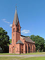
In Diesdorf is the church of St. Maria and Crucis of the Augustinian Canons' Monastery founded in 1161 by Count Hermann von Warpke-Lüchow, construction of which began in 1182. The brick church in Romanesque style is one of the oldest in the Altmark, which has a complete groin vault . Its interior is shaped by the construction in the bound system . Its exterior shows decorative elements such as pilaster strips , cross-arch frieze , diamond frieze , zigzag frieze and German ribbon . The tower in neo-Romanesque style, visible from afar , was built from 1863.
Former monastery grounds
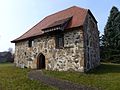
One of the earlier monastery buildings is the "Alte Darre", which was built in the 14th century and was formerly used as a brewery and bakery. At the beginning of the 2010s it was restored and set up as a local history museum. The wall around the monastery grounds has largely been preserved.
Diesdorf open-air museum

The Diesdorf open-air museum shows, among other things, half-timbered houses of various purposes and shapes as well as a post mill . Thematically, the museum relates to the Altmark .
Great stone graves near Diesdorf

In the vicinity of Diesdorf are the megalithic graves at Diesdorf , a group of three still preserved Neolithic grave complexes.
Transport and economy
traffic
Diesdorf is on the state roads 8 Wittingen –Salzwedel (part of the German half-timbered road ) and 11 Diesdorf– Beetzendorf –Apenburg (part of the Romanesque Road ). Until the closure of the section Diesdorf- Dähre the railway Salzwedel-Diesdorf on 23 May 1993, the site was connected to the railway network. Rail traffic to Wittingen and Beetzendorf was stopped in 1945 and 1973 respectively. Today all routes are dismantled.
economy
A natural gas cavern storage facility with a current storage volume of 400 million cubic meters is located in the Peckensen district .
Personalities
- August Zarnack (1777–1827) preacher, teacher and folk song collector, born in Mehmke
- Heinrich Mahlke (1851–1921), member of the Reichstag, born in Dankensen
- Eduard von Westernhagen (1851–1921), Prussian lieutenant general, born in Abbendorf
- Adolf Heitmann (1858–1946), educator and writer, born in Diesdorf
- Fritz Darges (1913–2009), SS-Obersturmbannführer, 1943–1944 personal adjutant to Adolf Hitler, born in Dülseberg
- Helmut Gäde (* 1932), crop scientist, born in Peckensen
Web links
Individual evidence
- ↑ State Statistical Office Saxony-Anhalt, population of the municipalities - as of December 31, 2019 (PDF) (update) ( help ).
- ↑ Main statutes of the village of Diesdorf (PDF; 94 kB)
- ↑ District directory of the state of Saxony-Anhalt (directory of the municipalities and parts of the municipality), territorial status January 2014, State Statistical Office Saxony-Anhalt, Halle (Saale), 2016
- ^ Adolph Friedrich Riedel: Codex diplomaticus Brandenburgensis: Collection of documents, chronicles and other source documents . Main part 1. Ed .: Berlin. tape 16 , 1859, pp. 393 ( digitized version ).
- ↑ Administrative region of Magdeburg (Ed.): Official Gazette of the Government of Magdeburg . 1928, ZDB -ID 3766-7 , p. 216 .
- ^ Peter P. Rohrlach: Historical local dictionary for the Altmark . Berliner Wissenschafts-Verlag, 2018, ISBN 978-3-8305-2235-5 , pp. 1363 .
- ↑ a b c Federal Statistical Office (ed.): Municipalities 1994 and their changes since 01.01.1948 in the new federal states . Metzler-Poeschel, Stuttgart 1995, ISBN 3-8246-0321-7 , pp. 361 ff .
- ↑ a b StBA: Area changes from January 1st to December 31st, 2010
- ↑ census database
- ^ Verbandsgemeinde Beetzendorf-Diesdorf: The final election result of the Diesdorf municipal council election on May 26th , 2019 , accessed on May 13th, 2020
- ↑ http://www.stala.sachsen-anhalt.de/wahlen/bm15/erg/gem/bm.15081105.20150222.ergtab.dr.html
- ↑ Peter Seyfried: The monastery church in Diesdorf . 3rd edition 1998 (DKV Art Guide No. 463).
- ↑ Internet presence of Storengy Deutschland GmbH
Abbendorf | Mountain moor | Thank you | Diesdorf | Duelberg | Haselhorst | Höddelsen | Hohenböddenstedt | Hohengrieben | Lindhof | Mehmke | Whey | Neuekrug | Peckensen | Reddigau | Schadeberg | Schadewohl | Waddekath | Wüllmersen