
Jübar
| coat of arms | Germany map | |
|---|---|---|

|
Coordinates: 52 ° 41 ′ N , 10 ° 55 ′ E |
|
| Basic data | ||
| State : | Saxony-Anhalt | |
| County : | Altmarkkreis Salzwedel | |
| Association municipality : | Beetzendorf-Diesdorf | |
| Height : | 75 m above sea level NHN | |
| Area : | 70.89 km 2 | |
| Residents: | 1574 (Dec. 31, 2019) | |
| Population density : | 22 inhabitants per km 2 | |
| Postal code : | 38489 | |
| Area code : | 039003 | |
| License plate : | SAW, GA, KLZ | |
| Community key : | 15 0 81 225 | |
| Community structure: | 8 districts | |
| Association administration address: | Marschweg 3 38489 Beetzendorf |
|
| Website : | ||
| Mayor : | Carsten Borchert ( CDU ) | |
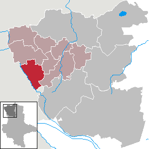
| Location of the community of Jübar in the Altmarkkreis Salzwedel | ||
  |
||

Jübar is a municipality in the Altmarkkreis Salzwedel in Saxony-Anhalt .
geography
The Altmark Jübar located 25 kilometers southwest of the county town Salzwedel . The Jübaren ditch flows east of the village and flows into the Hartau in Lüdelsen. In the north lies the almost 108 meter high Kahnberg, the highest point in the municipality of Jübar. In the south lies the almost 94 meter high Bromer Berg.
The west of the municipality borders on the state border with Lower Saxony , which in this area largely runs along the Ohre .
Community structure
Districts of the community are Bornsen , Drebenstedt , Gladdenstedt , Hanum , Jübar, Lüdelsen , Nettgau and Wendischbrome . The community's splinter settlements are Neuenstall , Klein Wismar and Groß Wismar.
history
History of the village of Jübar
Jübar found as Jubere in 1240 its first documentary mention, as de Albertus and Hogerus Jubere the pin Hamersleben a hoof in Mount Moor handed. It was first mentioned as a village ( villa ) itself in 1308.
The village was in the 13th / 14th. Century in the geographical border position of the German- Slavic area. Neither the one nor the other origin could be proven. The place name often changed over the centuries from Inbere to Jobere and Inber to Jübar. According to medievalists, the name should refer to the " linden tree ". In fact, there are two centuries-old - already hollow - linden trees in the north and south of the oval, which, as a natural monument, give the village its own character and are popularly known as the "thousand-year-old linden trees". That is why the linden tree was given to the graphic designer as a symbol by resolution of the municipal council. The red Brandenburg eagle indicates that it once belonged to the Mark Brandenburg .
In the land register of Emperor Charles IV of 1375, Jübar belonged to Isenhagen Abbey . The hoof land comprised 22 hooves , 14 of which were desolate . In the year the land was created , the village passed to the Diesdorf monastery .
In the Middle Ages and beyond, Jübar looked after some of the surrounding villages as a church village. These included the churchless Bornsen , presumably Lüdelsen and Gladdenstedt (both medieval desolations ) as well as the daughter churches in Hanum and Mellin . The historical population of the Sprengels from 1674 to 1814 is documented in a local family book .
Incorporations
Since 1991 Jübar has been part of the Beetzendorf administrative community, which was merged into the Beetzendorf-Diesdorf administrative community from 2005 . Jübar has been part of the Beetzendorf-Diesdorf community since January 1, 2010 .
The municipal councils of the municipalities of Bornsen (on May 25, 2009), Hanum (on June 3, 2009), Jübar (on June 3, 2009), Lüdelsen (on May 13, 2009) and Nettgau (on June 4, 2009) decided by means of a territorial change agreement 2009), that their congregations will be dissolved and merged into a new congregation called Jübar . This contract was approved by the county as the lower local supervisory authority and came into effect on January 1, 2010.
Population development
local community
|
|
|
|
District
|
Swell:
religion
The Protestant church Jübar belonged to the parish Jübar and now belongs to the parish area Rohrberg the church district Salzwedel in Propst Sprengel Stendal Magdeburg of the Evangelical Church in Central Germany .
In 1903 the parish of Jübar belonged to the parish of Jübar, in which the villages of Bornsen , Gladdenstedt , Lüdelsen and Neuenstall were parish, as well as the parishes of Hanum and Mellin . After the inauguration of the Lüdelsen Memorial Church in 1924, the Lüdelsen parish was established there and Neuenstall was churched into it. In 1973 the parishes of Jübar, Lüdelsen and Hanum form the parish of Jübar.
politics
coat of arms
What coat of arms was approved on December 15, 1992 by the Ministry of the Interior. Through the union of the five communities Bornsen, Hanum, Jübar, Lüdelsen and Nettgau, the new community Jübar has applied for the continuation of the community coat of arms of the old community Jübar. This continuation was approved on May 11, 2010 by the district.
Blazon : "A green linden tree with a black trunk growing in silver from a green shield base, accompanied by a red eagle reinforced with black at the top right."
flag
The flag is striped white and green and has the municipal coat of arms.
Culture and sights
- In the Mehmker Weg 1 schoolyard , a memorial stone commemorates the KPD chairman Ernst Thälmann , who was murdered in the Buchenwald concentration camp in 1944 and whose name this school bore in the GDR.
- In the middle of the village there is an approximately 1000-year-old linden tree, which is a natural monument and is Jübar's landmark.
Jübar village church

The church is a medieval stone building from the 13th century. In 1899, a neo-Romanesque brick west tower was added. The organ of the church was created in 1866 by the organ builder August Troch from Neuhaldensleben . The work has eight registers on a manual and pedal. The disposition is:
Manual: Principal 8 ', Gedackt 8', Viola da Gamba 8 ', Octave 4', Flute 4 ', Mixtur (3-4f.?)
Pedal: Subbass 16', Octavbass 8 '
Pedal coupler
Public buildings
- Parish hall
- Gym
- Library Jübar
- primary school
- Jübar village church
Awards
The village of Jübar has received several awards. In 1996 and 1999 Jübar was the most beautiful village in the Altmark district of Salzwedel, in 1997 and 2001 it won the Magdeburg administrative district in the competition “ Our village should be more beautiful ” and “Our village has a future”. In 2001 Jübar won the bronze plaque in the national competition “Our village has a future”.
economy
The largest employer in the Jübar community is the Sonae Arauco Deutschland chipboard plant near Gladdenstedt.
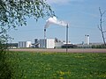
Chipboard plant of Glunz AG
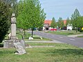
Gladdenstedt, town center
Nettgau

Wendischbroma


Personalities
- Hartmut Bock (* 1944), teacher, museologist, local researcher and honorary citizen of Jübar
literature
- Lieselott Enders : The Altmark. History of a Kurmark landscape in the early modern period (end of the 15th to the beginning of the 19th century) (= Klaus Neitmann [Hrsg.]: Publications of the Brandenburg State Main Archives . Volume 56). Berliner Wissenschafts-Verlag, Berlin 2008, ISBN 978-3-8305-1504-3 .
- Peter P. Rohrlach: Historical local dictionary for the Altmark. Volume 1: A-K . In: Historisches Ortslexikon für die Altmark (= Historisches Ortslexikon für Brandenburg . Teil XII; Klaus Neitmann [Hrsg.]: Publications of the Brandenburg State Main Archives . Volume 68; Publications of the State Archives Administration of the State of Saxony-Anhalt. Series A. Sources for the history of Saxony- Reference Volume 23). 2 volumes, Berliner Wissenschafts-Verlag, Berlin 2018, ISBN 978-3-8305-3743-4 , Jübar wnw Klötze, pp. 1089-1093.
- Johannes Schultze (Hrsg.): The land book of the Mark Brandenburg of 1375 (= Brandenburg land books . Volume 2; publications of the historical commission for the province of Brandenburg and the imperial capital Berlin . Volume VIII, 2). Commission publisher von Gsellius, Berlin 1940 ( digitized in Potsdam University Library ).
- Joachim Stephan: The Vogtei Salzwedel. Country and people from the development of the country to the time of turmoil . Dissertation Humboldt-Universität zu Berlin 2003 (= Klaus Neitmann [Hrsg.]: Sources, finding aids and inventories of the Brandenburg State Main Archives . Volume 17). Peter Lang. European Science Publishing House, Frankfurt am Main 2006, ISBN 3-631-54808-7 .
Web links
- Jübar community
- Municipality of Jübar on the website of the Verbandsgemeinde Beetzendorf-Diesdorf
- Jübar in the historical directory of the association for computer genealogy
Individual evidence
- ↑ State Statistical Office Saxony-Anhalt, population of the municipalities - as of December 31, 2019 (PDF) (update) ( help ).
- ↑ Saxony-Anhalt viewer of the State Office for Surveying and Geoinformation ( notes )
- ↑ Main statutes of the Jübar community (PDF; 96 kB)
- ^ Walter Zöllner : The documents and records of ownership of the Hamersleben monastery (1108–1462) . In: Studies on the history of the Catholic diocese and monastery . tape 17 . St. Benno Verlag, Leipzig 1979, p. 166-167 .
- ^ Adolph Friedrich Riedel : Codex diplomaticus Brandenburgensis : Collection of documents, chronicles and other source documents . Main part 1st volume 22 . Berlin 1862, p. 108 ( digitized version - XLIII).
- ↑ Johannes Schultze (ed.): The land book of the Mark Brandenburg from 1375 . Commission publisher von Gsellius, Berlin 1940, Antiqua marchia. Equitatura terre Soltowedel foris Portam Buchornighe. Juber, p. 401.
- ↑ a b c d Peter P. Rohrlach: Historical local lexicon for the Altmark (Historical local lexicon for Brandenburg, Part XII) . Berliner Wissenschafts-Verlag, Berlin 2018, ISBN 978-3-8305-2235-5 , pp. 1089-1093 .
- ^ Lieselott Enders: The Altmark . Berliner Wissenschafts-Verlag, Berlin 2008, ISBN 978-3-8305-1504-3 , D. Culture and way of life in town and country. I. Church, clergy and religious communities. 1. Church and parish organization. Großparochien, pp. 1169–1174, Jübar: p. 1171.
- ↑ Ulf Queckenstedt: Ortsfamilienbuch Jübar . ( online-ofb.de ).
- ↑ Information folder for the state competition "Our village has a future" in the state of Saxony-Anhalt 2017 . 2017 ( juebar.eu [PDF; accessed March 3, 2018]).
- ^ Altmarkkreis Salzwedel (ed.): Official Gazette Altmarkkreis Salzwedel . 15th year, no. 7 . Salzwedel July 29, 2009, p. 180–183 ( altmarkkreis-salzwedel.de [PDF; 1.8 MB ; accessed on March 3, 2018]).
- ↑ StBA: Area changes from January 1 to December 31, 2010
- ^ Verbandsgemeinde Beetzendorf-Diesdorf: residents of the districts on December 31 for 2015 and 2018 . June 6, 2019.
- ^ A b parish almanac or the evangelical clergy and churches of the province of Saxony in the counties of Wernigerode, Rossla and Stolberg . 19th year, 1903, ZDB -ID 551010-7 , p. 98 ( wiki-de.genealogy.net [accessed March 3, 2018]).
- ↑ Rohrberg parish area. Retrieved March 3, 2018 .
- ↑ Official Journal of the District No. 6/2010 page 129 ( Memento of March 4, 2016 in the Internet Archive )
- ↑ a b Administrative Community Beetzendorf - Diesdorf: Jübar
- ↑ Thomas Hartwig: All Altmark churches from A to Z . Elbe-Havel-Verlag, Havelberg 2012, ISBN 978-3-9814039-5-4 , p. 215 .
Bornsen | Drebenstedt | Gladdenstedt | Hanum | Jübar | Lüdelsen | Nettgau | Wendischbroma