
Wallstawe
| coat of arms | Germany map | |
|---|---|---|

|
Coordinates: 52 ° 48 ' N , 11 ° 1' E |
|
| Basic data | ||
| State : | Saxony-Anhalt | |
| County : | Altmarkkreis Salzwedel | |
| Association municipality : | Beetzendorf-Diesdorf | |
| Height : | 32 m above sea level NHN | |
| Area : | 44.09 km 2 | |
| Residents: | 879 (Dec. 31, 2019) | |
| Population density : | 20 inhabitants per km 2 | |
| Postal code : | 29413 | |
| Area code : | 039033 | |
| License plate : | SAW, GA, KLZ | |
| Community key : | 15 0 81 545 | |
| Association administration address: | March 3
38489 Beetzendorf |
|
| Website : | ||
| Mayor : | Frank Wulff | |
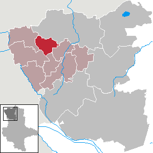
| Location of Wallstawe in the Altmarkkreis Salzwedel | ||
  |
||


Wallstawe is a municipality in the Altmarkkreis Salzwedel in Saxony-Anhalt .
geography
The Altmark village of Wallstawe is located around eleven kilometers southwest of the district town of Salzwedel on the Beeke, which flows into the Salzwedeler Dumme in the north of the village .
Community structure
The following districts belong to the municipality of Wallstawe, which was founded on July 1, 2009:
|
history
On the Urmes table sheet of 1823, Wallstawe has the shape of a street green village with a church, but was originally built round ( Rundling ).
In the year 1251 Bodo de Walstawen is mentioned in Salzwedel.
Wallstawe was first mentioned in a document in 1306, when Burchard von Wallstawe notarised his donation to the Diesdorf monastery in Walstawe . The von Wallstawe family lived in Wallstawe until the 14th century.
In the Landbuch der Mark Brandenburg from 1375 the place is listed as Valstove and Walstove . Later, the entire ownership of von Wallstawe passed to von der Schulenburg zu Beetzendorf and Apenburg.
State sovereignty was initially with the Margrave of Brandenburg, before 1402 partially or later completely and until 1692 with the Duke of Braunschweig-Lüneburg. In 1687 it was said: "Is not Brandenburg, not even Lüneburg, is in dispute, is therefore not charged with any contribution, so are free people."
With the Treaty of Wallstawe of 1692 Wallstawe came as a former Lüneburg exclave in the Electorate of Brandenburg an Brandenburg.
In 1823 the village was devastated by a great fire.
In the middle of the 20th century, two mills on the Beeke in the Mühlenwiesen north of the village were recorded on the table sheet, a watermill at the northern end of the village (Wallstawer Mühle) and a windmill further north.
In 1954 the first type III agricultural production cooperative, the LPG “IV. Party Congress ".
Ramparts
Wilhelm Zahn reports: Immediately to the west of the village of Wallstawe is a small piece of land called the Willerburg ... The name does not appear in a document. In Wallstawe there was a castle in the Middle Ages, the ancestral seat of the von Walstawe knight family, who flourished from 1351 to the beginning of the 15th century. But it cannot be proven whether the Willerburg is the site of this knight's castle.
Paul Grimm reported about it in 1958: According to local tradition, the ancestral seat of the von Wallstawe family was at the eastern end of the Beekeaue in the north-western part of the village. On the western bank of the Beeke, opposite the village, were the ruins of Knesebeck Castle, a castle hill that was still marked as a significant elevation in 1823.
The “Niebitzburg”, also known as “Nieberburg”, is a heavily plowed in prehistoric castle rampart with a diameter of about 100 meters. It is located on the westernmost part of the Wallstawe field mark, on the right bank of the Molmker Bach.
Incorporations
The community of Wallstawe was reclassified from the district of Salzwedel to the district of Salzwedel on July 25, 1952 . On July 1, 1994 she came to the Altmarkkreis Salzwedel. By a non amendment agreement, the municipal councils of the municipalities decided Gieseritz (November 18, 2008) and, Wallstawe (2008 November 19) Ellenberg (20 November 2008) that their communities and added to a new community named Wallstawe be united . This contract was approved by the county as the lower local supervisory authority and came into effect on July 1, 2009.
Population development
local community
|
|
|
|
District
|
Swell:
religion
The Protestant parish Wallstawe used to belong to the parish Wallstawe. In 1978 the parish Wallstawe was formed from the parishes of Wallstawe, Gieseritz, Groß Wieblitz, Hilmsen, Peckensen and Tylsen, which today belongs to the parish of Diesdorf in the parish of Salzwedel in the Provostspengel Stendal-Magdeburg of the Evangelical Church in Central Germany .
coat of arms
The coat of arms was designed by the heraldist Uwe Reipert.
Culture and sights
- The Protestant village church in Wallstawe is a late Romanesque field stone building from the 13th century. In 1328 an altar in honorem dei et Beate Katherine in Ecclesia Walstoue (an altar in honor of St. Catherine in the Wallstawe church) is mentioned. The St. Catharine Church in Wallstawe is mentioned in 1350 . In 1341 an altar is called John the Baptist. The wooden pulpit altar with side passages and delicate ornamental carvings dates from 1735. In 1895 an organ was installed.
- About a kilometer east of the village is the cemetery.
- In Wallstawe there is a memorial for the fallen of the First and Second World Wars, an obelisk with a laurel wreath and cross.
societies
- Friends of the Wallstawe Volunteer Fire Brigade eV
- Wallstawe hunting horn group
- Schützenverein Wallstawe 1870 eV
- Sportgemeinschaft Wallstawe eV
Personalities
- Konrad-Oskar Heinrichs (1890–1944), German general
Web links
- Wallstawe parish
- Wallstawe in the historical directory of the Association for Computer Genealogy
literature
- Peter P. Rohrlach: Historical local lexicon for the Altmark (Historical local lexicon for Brandenburg, Part XII) . Berliner Wissenschafts-Verlag, Berlin 2018, ISBN 978-3-8305-2235-5 , pp. 2342-2346 .
- Wilhelm Zahn : Local history of the Altmark . Edited by Martin Ehlies based on the bequests of the author. 2nd Edition. Verlag Salzwedeler Wochenblatt, Graphische Anstalt, GmbH, Salzwedel 1928, DNB 578458357 , p. 155-156 .
- JAF Hermes, MJ Weigelt: Historical-geographical-statistical-topographical handbook from the administrative districts of Magdeburg . Topographical part. Ed .: Verlag Heinrichshofen. tape 2 , 1842, p. 349 ( digitized version ).
Individual evidence
- ↑ State Statistical Office Saxony-Anhalt, population of the municipalities - as of December 31, 2019 (PDF) (update) ( help ).
- ↑ a b c Saxony-Anhalt viewer of the State Office for Surveying and Geoinformation ( notes )
- ^ Altmarkkreis Salzwedel (ed.): Official journal for the Altmarkkreis Salzwedel . Main statutes of the Wallstawe community. 15th year, no. 9 . Salzwedel September 16, 2009, p. 263–265 ( PDF; 0.4 MB [accessed March 30, 2018]).
- ↑ District directory of the state of Saxony-Anhalt (directory of the municipalities and parts of the municipality), territorial status January 2014, State Statistical Office Saxony-Anhalt, Halle (Saale), 2016
- ↑ a b c d e f Peter P. Rohrlach: Historical local lexicon for the Altmark (Historical local lexicon for Brandenburg, Part XII) . Berliner Wissenschafts-Verlag, Berlin 2018, ISBN 978-3-8305-2235-5 , pp. 2342-2346 .
- ^ Hermann Krabbo : Regesta of the Margraves of Brandenburg from Ascanic house . Ed .: Association for the history of the Mark Brandenburg. 1. Delivery. Duncker & Humblot, Leipzig 1910, p. 168 , No. 734 ( uni-potsdam.de ).
- ^ Adolph Friedrich Riedel : Codex diplomaticus Brandenburgensis : Collection of documents, chronicles and other source documents . Main part 1st volume 22 . Berlin 1862, p. 105-106 ( digitized version ).
- ↑ Johannes Schultze : The land book of the Mark Brandenburg from 1375 (= Brandenburg land books . Volume 2 ). Commission publisher von Gsellius, Berlin 1940, p. 383 ( uni-potsdam.de ).
- ↑ Johannes Schultze : The land book of the Mark Brandenburg from 1375 (= Brandenburg land books . Volume 2 ). Commission publisher von Gsellius, Berlin 1940, p. 402 ( uni-potsdam.de ).
- ^ Table sheet 3132: Salzwedel. Ministry of the Interior, 1955, accessed March 30, 2018 .
- ^ Wilhelm Zahn : The desolation of the Altmark . In: Historical sources of the Province of Saxony and neighboring areas . tape 43 . Hendel, Halle as 1909, p. 432 , no.561 .
- ↑ Paul Grimm : Handbook of the prehistoric and early historical ramparts and weir systems . The prehistoric and early historical castle walls of the districts of Halle and Magdeburg (= publications of the section for prehistory and early history . Volume 6 ). Berlin 1958, p. 381 , no.1025 and 1026 .
- ^ Wilhelm Zahn : The desolation of the Altmark . In: Historical sources of the Province of Saxony and neighboring areas . tape 43 . Hendel, Halle as 1909, p. 380 , no. 389 .
- ↑ Federal Statistical Office (Ed.): Municipalities 1994 and their changes since 01.01.1948 in the new federal states . Metzler-Poeschel, Stuttgart 1995, ISBN 3-8246-0321-7 , pp. 360 .
- ↑ Official Journal of the District No. 2/2009 Pages 31–33 ( Memento of November 14, 2012 in the Internet Archive ) (PDF; 397 kB)
- ^ StBA: Area changes from January 2 to December 31, 2009
- ^ Verbandsgemeinde Beetzendorf-Diesdorf: residents of the districts on December 31 for 2015 and 2018 . June 6, 2019.
- ↑ Parish Almanac or the Protestant clergy and churches of the Province of Saxony in the counties of Wernigerode, Rossla and Stolberg . 19th year, 1903, ZDB -ID 551010-7 , p. 100 ( wiki-de.genealogy.net [accessed March 30, 2018]).
- ↑ Diesdorf parish area. Retrieved March 30, 2018 .
- ↑ Thomas Hartwig: All Altmark churches from A to Z . Elbe-Havel-Verlag, Havelberg 2012, ISBN 978-3-9814039-5-4 , p. 520 ( limited preview in Google Book Search).
- ^ Adolph Friedrich Riedel : Codex diplomaticus Brandenburgensis : Collection of documents, chronicles and other source documents . Main part 1st volume 17 . Berlin 1859, p. 236 ( digitized version ).
- ^ Adolph Friedrich Riedel : Codex diplomaticus Brandenburgensis : Collection of documents, chronicles and other source documents . Main part 1st volume 5 . Berlin 1845, p. 293 ( digitized version ).
- ↑ Online project monuments to the likes. In: Wallstawe at www.denkmalprojekt.org. November 30, 2006, accessed March 30, 2018 .