
Boitzenhagen
|
Boitzenhagen
City of Wittingen
Coordinates: 52 ° 36 ′ 57 ″ N , 10 ° 48 ′ 46 ″ E
|
|
|---|---|
| Height : | 95 m |
| Area : | 17.18 km² |
| Residents : | 238 (December 31, 2017) |
| Population density : | 14 inhabitants / km² |
| Incorporation : | March 1, 1974 |
| Postal code : | 29378 |
| Area code : | 05836 |
 Location of Boitzenhagen in Wittingen
|
|
Boitzenhagen is a district of the city of Wittingen in the district of Gifhorn in Lower Saxony .
geography
The place is southeast of the core area of Wittingen.
The B 244 runs to the east and the B 248 to the south . A state road leads in a south-north direction from Ehra through Boitzenhagen to Ohrdorf .
politics
Mayor is Klaus Palluk.
Culture and sights
In the forest area of the Bickelsteiner Heide between Boitzenhagen and Ehra-Lessien lies the Bickelstein , a 2.5 meter long and 1.2 meter high ice age boulder made of reddish granite . The stone, which is the most famous boulder in the Wolfsburg-Gifhorn area and the landmark of the Ehra-Lessien community, has markings similar to a horseshoe and a cross.

Main street, village community center on the right (former school)
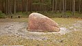
The Bickelstein

Web links
Individual evidence
- ↑ Population figures and area from wittingen.de (PDF file, 34 kB, last accessed on May 9, 2017)
- ↑ Population figures from wittingen.de (PDF file, 34 kB, last accessed on August 27, 2019)
- ↑ Mayor of the city of Wittingen
- ↑ The Bickelstein - An enigmatic stone monument
Boitzenhagen | Darrigsdorf | Erpensen | Use | Gannerwinkel | Glüsingen | Hagen | Kakerbeck | Knesebeck | Küstorf | Lüben | Mahnburg | Ohrdorf | Plastau | Wheel | Radenbeck | Schneflingen | Sticks | Suderwittingen | Teschendorf | Transvaal | Pre-hop | Wollerstorf | Wunderbüttel | Zasenbeck