Burgdorf (Wolfenbüttel district)
| coat of arms | Germany map | |
|---|---|---|

|
Coordinates: 52 ° 9 ' N , 10 ° 13' E |
|
| Basic data | ||
| State : | Lower Saxony | |
| County : | Wolfenbüttel | |
| Joint municipality : | Baddeckestedt | |
| Height : | 106 m above sea level NHN | |
| Area : | 24.07 km 2 | |
| Residents: | 2223 (Dec. 31, 2019) | |
| Population density : | 92 inhabitants per km 2 | |
| Postal code : | 38272 | |
| Area code : | 05347 | |
| License plate : | WF | |
| Community key : | 03 1 58 004 | |
| Community structure: | 5 districts | |
| Association administration address: | Heerer Strasse 28 38271 Baddeckestedt |
|
| Website : | ||
| Mayor : | Bernd Brandes ( SPD ) | |
| Location of the municipality of Burgdorf in the Wolfenbüttel district | ||
Burgdorf is a municipality in the north of the combined municipality Baddeckestedt in the district of Wolfenbüttel , Lower Saxony , Germany .
geography
location
The municipality of Burgdorf is located west of the independent city of Salzgitter , east-northeast of the Vorholz ridge and north of the Lichtenberge ridge (northwestern part of the Salzgitter ridge ). It is located north of Baddeckestedt (seat of the joint municipality administration) and northeast of Holle and south of Söhlde , which are located in the neighboring district of Hildesheim to the west .
With an area of 24.06 km², Burgdorf is the largest member municipality of the combined municipality of Baddeckestedt.
Community structure
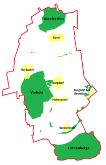
The five districts of the municipality are:
- Burgdorf with Burgdorf bei Osterlinde
- Berel
- Hohenassel
- North Assel
- Westerlinde
history
The district of Burgdorf was first mentioned in a document under the name Borchtorp in 1243. Presumably, however, the village already existed earlier under names such as Asla , Assle or Assel . Initially, Burgdorf consisted of the so-called Old Village . Only later did the inhabitants of the deserted Steinum settlement move to the east of the village.
Since the late Middle Ages, Burgdorf has belonged to the Lichtenberg district and thus to the Principality of Braunschweig-Wolfenbüttel . In the Thirty Years War from 1618 to 1648 Burgdorf was also destroyed. For example, six houses burned down in September 1634. In 1640 and 1642 the place was almost completely destroyed, first by imperial troops, then by the Swedes.
In 1865 a sugar factory was built in what is now Burgdorf near Osterlinde. The school in Burgdorf was closed in 1976.
Incorporations
On June 28, 1965, the then independent municipalities of Burgdorf, Berel, Hohenassel, Nordassel and Westerlinde were founded to form the joint municipality of Burgdorf-Assel.
On March 1, 1974, the joint congregation was dissolved. The community of Burgdorf was formed from its member communities and became part of the newly founded joint community of Baddeckestedt.
Population development
The table shows the population including secondary residences as of December 31 of the respective year.
| District and municipality of Burgdorf - population development since 1840 | |||||||||||||||||||||||
|---|---|---|---|---|---|---|---|---|---|---|---|---|---|---|---|---|---|---|---|---|---|---|---|
| Burgdorf district | Burgdorf community |
 |
|||||||||||||||||||||
|
|
||||||||||||||||||||||
religion
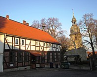
- The church in Burgdorf was probably built in the 12th century. The fortified church has a Romanesque tower with a dome from 1766. Already in 1616 a window in the church was renewed. From 1727 to 1732 there was a major renovation. In 1953 the tower roof was replaced before renovations were carried out again from 1963 to 1965. Today the Protestant church belongs to the parish of Burgdorf-Assel. It is a listed building along with the rectory and the churchyard
- In the post-war period, catholic services took place in the castle, at times also in the Protestant church. From 1981 to 2007 the Catholic chapel of St. Maria Rosenkranz was located in the former school . The nearest Catholic church with regular services is now 5 km away in Salzgitter- Fredenberg .
politics
|
Municipal election 2016
Turnout: 63.89% (+1.53% p)
% 70 60 50 40 30th 20th 10
0
43.79%
(-19.71 % p ) 32.71%
(-3.79 % p ) 23.48%
( n. K. ) 2011
2016
Remarks:
c Citizens' community of voters for Burgdorf
|
|
Distribution of seats in the municipal council
A total of 13 seats
|
Municipal council
The municipal council from Burgdorf consists of 13 councilors (change from 2011).
(Status: local election on September 11, 2016 )
mayor
The honorary mayor Bernd Brandes (SPD) was elected at the beginning of the current legislative period.
coat of arms
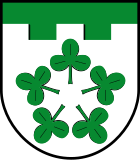
Under a green shield head in silver (white), which is divided off by a tin cut, five green shamrocks arranged in a five-pass pattern.
Culture and sights
- One of the oldest houses in the community is in the Westerlinde district. The listed building from 1661 is located on the farm of the Bock family.
- The Heimatstube is located on the first floor of the old school building and, as a museum of local history, shows pictures, documents and tools from the region's agriculture and handicrafts.
- The Asselburg , also called Hesleburg, was first mentioned in a document in 984. This year a prince assembly took place there, at which the Saxon Duke Bernhard, other Saxon nobles and West German allies met. The goal was Otto III. , the three-year-old son of Emperor Otto II , to secure the succession that the Bavarian duke contested him. After Lichtenberg Castle was built , the castle lost its importance. It was mentioned for the last time in 1202.
- Today's Burgdorf Castle was built by Georg Heinrich Gottschalk von Kniestedt from 1779 to 1783 as a mansion on the site of the former castle, of which only part of the ramparts and the moat have survived. Until 1834 the manor house was managed by the von Kniestedt family, who had owned the site and the goods of the former Asselburg since 1596. After that it changed hands several times. Since 1985, the individual partially dilapidated buildings have been repaired. The castle, the park with its trees and the entrance gate have been under monument protection since 1994.
Economy and Infrastructure
Educational institutions
There is a primary school in the Hohenassel district. Secondary schools in the area are in Baddeckestedt, Salzgitter- Lebenstedt , Söhlde and Ottbergen.
traffic
The federal motorway 39 with the driveway in Westerlinde is located in the southern municipal area.
The nearest train stations are in Salzgitter-Lebenstedt on the Braunschweig – Salzgitter-Lebenstedt railway , in Baddeckestedt on the Hildesheim – Goslar railway and in Hoheneggelsen on the Hildesheim – Braunschweig railway .
The station in Burgdorf bei Osterlinde was shut down in 1984 along with the entire railway line between Salzgitter-Lebenstedt and Derneburg and then dismantled.
Personalities
- Friedrich Julius von Kniestedt (1765–1825), lawyer and landowner
- Karl Schaper (1920–2008) painter, sculptor, graphic artist and conceptual artist
literature
- Samtgemeinde Baddeckestedt (Ed.): 25 years of the Samtgemeinde Baddeckestedt - 1974–1999. Festschrift ; 1999.
- Kirstin Casemir: The place names of the Wolfenbüttel district and the city of Salzgitter. ISSN 0436-1229 , ISBN 3-89534-483-4 (Dissertation 2002, Georgia Augusta zu Göttingen).
Web links
Individual evidence
- ↑ State Office for Statistics Lower Saxony, LSN-Online regional database, Table 12411: Update of the population, as of December 31, 2019 ( help ).
- ^ Samtgemeinde Baddeckestedt (ed.): 25 years of the Samtgemeinde Baddeckestedt - 1974–1999. Festschrift ; 1999 (p. 10).
- ^ Federal Statistical Office (ed.): Historical municipality directory for the Federal Republic of Germany. Name, border and key number changes in municipalities, counties and administrative districts from May 27, 1970 to December 31, 1982 . W. Kohlhammer GmbH, Stuttgart and Mainz 1983, ISBN 3-17-003263-1 , p. 273 .
- ↑ Burgdorf district on the website of the Samtgemeinde Baddeckestedt , accessed on March 21, 2018.
- ↑ a b Samtgemeinde Baddeckestedt (Ed.): 25 years of the Samtgemeinde Baddeckestedt - 1974–1999. Festschrift ; 1999 (p. 17).
- ↑ a b State Office for Statistics and Communication Technology Lower Saxony, 100 population update - based on the 2011 census, as of December 31, 2016.
- ↑ Website of the municipal services Oldenburg , accessed on September 14, 2016.


