Hohenassel
|
Hohenassel
Municipality Burgdorf
Coordinates: 52 ° 8 ′ 11 ″ N , 10 ° 13 ′ 14 ″ E
|
|
|---|---|
| Height : | approx. 125 m above sea level NN |
| Residents : | 380 (Jan 1999) |
| Incorporation : | March 1, 1974 |
| Postal code : | 38272 |
| Area code : | 05347 |
|
Location of Hohenassel in the municipality of Burgdorf
|
|
|
South-eastern outskirts of Hohenassel
|
|
Hohenassel is a district of the municipality of Burgdorf , which belongs to the combined municipality of Baddeckestedt in the Wolfenbüttel district in Lower Saxony.
geography
The following places surround Hohenassel:
- Burgdorf in the north
- Lesse in the northeast
- Burgdorf near Osterlinde in the east
- Osterlinde in the southeast
- Westerlinde in the south
- Grasdorf and Wartjenstedt in the southwest
- Luttrum in the west-southwest
- North Assel in the northwest
Hohenassel is east of a smaller forest area and is otherwise surrounded by fields.
history
Grave fields were discovered in Hohenasseler Holz that date from the 2nd to 5th centuries AD and thus point to an early settlement history of the village.
The naming, like that of Nordassel, indicates the close connection with the Asselburg in Burgdorf, which was first mentioned in 984.
Since the late Middle Ages, Hohenassel has belonged to the Lichtenberg office and thus to the Principality of Braunschweig-Wolfenbüttel . As early as 1548 there was a chapel with a school in the village. In 1792 the Lichtenberg office was relocated to Salder . The school was given its own building in 1880, which was again replaced by a new one in 1976, in which all primary school students in the Burgdorf community are taught to this day.
Oil production

During the Second World War in October 1943, oil deposits were discovered near Hohenassel. As early as 1942, geophysical measurements revealed salt domes in this area. The boundary surfaces of such structures form potential trap structures in that they laterally seal off adjacent dislocated layers that could serve as storage rock. The second exploration well was finally successful, so that after another well was sunk from October 21, 1943 to the end of the same year, 1150 tons of oil were produced by means of production probes. In 1944 up to four drilling rigs were in operation at the same time and one year later there were already 15 extraction locations, so that an annual extraction of over 31,000 tons could be achieved. In the post-war years 1946/47 the company employed up to 141 people (December 1947). Annual production reached its peak in 1946 at 48,680 tons. In the period that followed, between 18,000 and 24,000 tons were mined annually until 1955. From 1956 onwards, rationalizations and falling productivity of the deposit led to staff reductions. The number of conveyor probes also steadily decreased. In 1963 production was just under 9,000 tons with 48 employees. Nevertheless, until July 25, 1990, oil was produced at an annually falling production rate. The total production in the 47 years of operation was almost 500,000 tons with a total of 62 wells in the Malm at a depth between 367 and 665 meters. By 1994, all of the boreholes were finally filled and the area renatured.
Population development
| Burgdorf-Hohenassel - population development since 1790 | ||
|---|---|---|
| year | Residents | development |
| 1790 | 266 |
 |
| 1900 | 310 | |
| Sep 30 1998 | 373 | |
| Jan. 1999 | 380 | |
Culture and sights
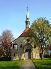
- The year of construction of the old Romanesque chapel with a rectangular nave and semicircular apse is not known. It was replaced in 1913 by the new St. Jakobi Chapel. Hohenassel belongs to the evangelical parish of Burgdorf.
- Today, two derricks are industrial monuments that commemorate the time of oil production.
Economy and Infrastructure
Transport links
Hohenassel is on a county road that connects Nettlingen and Luttrum in the west-southwest with Burgdorf bei Osterlinde in the east. In addition, there is another county road, which connects the village to Westerlinde and the federal highway 39 in the south and to Burgdorf in the north.
The nearest train stations are in Salzgitter- Lebenstedt on the Braunschweig – Salzgitter-Lebenstedt railway , in Baddeckestedt on the Hildesheim – Goslar railway and in Hoheneggelsen on the Hildesheim – Braunschweig railway .
literature
- Samtgemeinde Baddeckestedt (Ed.): 25 years of the Samtgemeinde Baddeckestedt - 1974–1999. Festschrift ; 1999 (pp. 20/21).
Web links
Individual evidence
- ^ Samtgemeinde Baddeckestedt (ed.): 25 years of the Samtgemeinde Baddeckestedt - 1974–1999. Festschrift ; 1999 (p. 20).
- ↑ Hohenassel on the website of the Samtgemeinde Baddeckestedt , accessed on March 28, 2018.
- ↑ Information board at the industrial monument for oil production near Hohenassel.


