Balance
|
Balance
City of Salzgitter
|
|
|---|---|
| Coordinates: 52 ° 8 ′ 14 ″ N , 10 ° 20 ′ 13 ″ E | |
| Height : | 91 m |
| Area : | 8.18 km² |
| Residents : | 1407 (Dec. 31, 2019) |
| Population density : | 172 inhabitants / km² |
| Incorporation : | April 1, 1942 |
| Incorporated into: | Watenstedt-Salzgitter |
| Postal code : | 38229 |
| Area code : | 05341 |
|
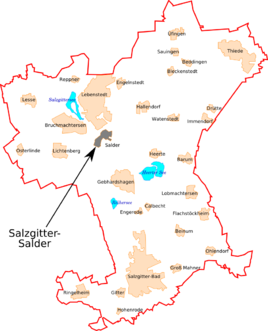
Location of Salder in Salzgitter
|
|
|
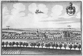
Salder around 1654/1658, engraving by Matthäus Merian
|
|
Salder is one of the total of 31 districts of the independent city of Salzgitter in Lower Saxony , located in the north . Salder belonged to the Wolfenbüttel district until March 31, 1942 and became part of the city of Watenstedt-Salzgitter through an administrative act on April 1, 1942 . On January 23, 1951, it was officially renamed Salzgitter .
geography
location
Salder is located north of the Lichtenberge , the northwest part of the elongated Salzgitter ridge , which in turn belongs to the northern Harz foreland . In the north-west the village flows almost smoothly into Lebenstedt , the largest district of Salzgitter.
geology
history
Place name
Salder was first mentioned in writing in 1161 when the name Thidericus de Saldere was mentioned in a document . The spelling of the place name varied little in the past and there are only rare deviations. B. in a document from 1428 an Edverd von Zaldere mentioned , 1569 the place is called Saller and 1623 is from a citizen Christoff Gerd von Gr. Salter 's speech.
There are different opinions about the interpretation of the place name, but none of them could prevail. One possible interpretation derives the name from the Old High German salhâ or salaha for Salweide , a tree that often grows outside of wetlands. Another explanation holds the Latin word saltus , which stands for mountainous, wooded land or forest mountains, as likely, which can be explained with the location of Salders on a slight hill on the Fuhse.
Origin of the place
The place is on a hill on the Fuhse and on an important military road in the Middle Ages. This was the "Magdeburger Königsweg" ( Deitweg ), a section of the Rhein-Elbe-Weg that, coming from Hildesheim , led past Lichtenberg and Salder over the Okerfurt near Ohrum and on to Halberstadt and Magdeburg . The valley of the Fuhse is narrowed at Salder by the approaching mountains, so that a transition over the river was created here, which was used by many other paths in addition to the Königsweg. A small castle was built near the place around the year 1000, which served to protect and control this crossing. This castle, referred to as the “Alter Hof” or “Kleiner Hof” in old maps by Salder, was also the first seat of the von Saldern family , which was mentioned as early as the 12th century.
The place had certainly been inhabited before. This is proven by excavation finds in the area of today's settlement "Teichkamp", which are dated to the early Roman Empire and which indicate continuous settlement between the 1st and 6th centuries. This was a smaller Germanic complex that consisted of a few scattered individual farmsteads. A second settlement from the early Roman imperial era was located in the west of Salders, for example on the site of today's cemetery, and another is believed to be on the border with the Heerte district . There are no other finds from the period after the 6th century, so it cannot be clarified whether the village of Salder, which was laid out around 1000, developed from these settlements or whether it was a new settlement.
The place above the Fuhse was surrounded by a protective wall, the church stood in the middle of the place. At the beginning of the 14th century, the residents of the surrounding villages Dutzum (called "Dusunhem" in 1022, north of the path between Salder and Watenstedt) and Klein-Lebenstedt (on the path from the old village of Lebenstedt to Hallendorf) moved their residence to Salder because they fortified location of the place could offer more security. The two villages were given up and fell desolate .
Affiliation of the place
The Lichtenberg Castle and the surrounding towns as well Salder belonged since the time of the Lion Henry the dominion of Guelph . From this the Duchy of Braunschweig-Lüneburg emerged in 1235 , after its division in 1269 the place fell to the Principality of Braunschweig-Wolfenbüttel .
Salder belonged to the Lichtenberg office, which reached its greatest extent in the middle of the 15th century. After the Lichtenberg office was downsized between 1539 and 1542 and part of the office was spun off into the new Gebhardshagen office , Salder stayed with Lichtenberg. When Duke August Wilhelm succeeded his father in 1714 , Salder and Watenstedt became an independent administrative and judicial district. In 1774, Duke Karl I merged the offices of Lichtenberg, Gebhardshagen and Salder to form the Salder office, and Salder Castle was the seat of the office from 1795 .
The Kingdom of Westphalia existed between the Peace of Tilsit in 1807 and the Battle of the Nations near Leipzig in 1813. During this time, the canton Salder belonged to the Braunschweig district of the Oker department . Watenstedt, Heerte, Barum , Hallendorf , Lewensiedt ( Lebenstedt ), Engelnstedt , Bleckenstedt , Sauingen , Üfingen and Alvesse with Wierthe (both today the Peine district ) belonged to the Salder canton from today's Salzgitter . After the Congress of Vienna in 1814/15, the old duchy was restored and divided into five districts. The former cantons Gebhardshagen , Salder and Lesse were merged to form the district court Salder (later district office Salder) and assigned to the Wolfenbüttel district, which became the Wolfenbüttel district directorate in 1832.
After the end of the First World War , the Free State of Braunschweig became the successor to the Duchy of Braunschweig - from 1933 as "Land Braunschweig" - and Salder became part of the Wolfenbüttel district . Since April 1, 1942, Salder has been part of the newly founded town of Watenstedt-Salzgitter - today's Salzgitter.
Noble family of Saldern
The noble family von Saldern was at home in Salder. Members of this family were already mentioned in the first documents of 1161 (Thidericus or Dietrich von Saldern as witness) and 1181 (four von Saldern brothers as witnesses). According to the family book, the family descends from Sieghard de Rossis, who came to Germania with Boniface in 718 . A descendant was enfeoffed with Salder in 870, and the family later named themselves after the place. The family seat was the castle at the crossing over the Fuhse. Members of the family served both the Duchy of Braunschweig and the Duchy of Hildesheim . By the 14th century the family developed into one of the wealthiest families in the Braunschweig-Hildesheim area, their possessions were in the entire Harz foreland and they had shares in the Goslar ( Rammelsberg ) and Upper Harz mining . Several members were lords of Lichtenberg Castle, to whose area the place belonged at that time. In 1695 the family sold their property in Salder to August Wilhelm , the Hereditary Prince of the Duchy of Braunschweig-Wolfenbüttel .
railroad
Of Braunschweig on Thiede and Salder after Derneburg leading railway of Brunswick State Railway Company was put into operation on July 18, 1886th The railway line and especially the Salder station became more important from 1937/38 when the Reichswerke Hermann Göring was built , because the goods destined for the Reichswerke were transferred to Salder via a specially set up head ramp for onward transport to the road. When Lebenstedt received its own rail connection in 1954, rail operations on the section via Salder were discontinued. The historic station building was sold, it was last restored in 2009/10 by the current owner, the local company Möhlenhoff GmbH, and serves as the company's headquarters.
Population development
A first report on the size of Salders can be found in a hereditary register of the Lichtenberg Office that was created in the middle of the 16th century. At that time there were three farms, six half-span farms and 53 farms belonging to the village, making Salder one of the large villages at that time. The first list of inhabitants from 1774 reports 552 inhabitants, 25 years later the place had 616 inhabitants. By 1900 the number increased to about 1,000 residents and then changed little until the mid-1930s. With the development of ore mining and the Reichswerke Hermann Göring, the number of inhabitants rose to over 1200 by 1939. There were major changes after the Second World War , when the influx of many refugees and displaced persons increased the population by around 50% to 1822 by 1946; the maximum was reached in 1960 with 2188 inhabitants. Salder has had around 1450 inhabitants since 2010.

Sources: The population figures from 1821 to 2000 are based on the statistical yearbook of the Department for Economics and Statistics of the city of Salzgitter. The population statistics from 2001 are based on the monthly statistical reports of the city of Salzgitter (residents with main residence) according to the population register at the end of December.
religion
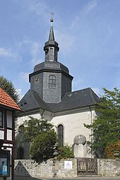
The first church in Salder is shown on a Merian engraving from 1654. The Romanesque church tower probably dates from the 11th or 12th century, the Gothic nave was probably added in the 13th century. The Reformation was introduced in 1568 by Duke Julius , after which Salder belonged to the Special Superintendentur Barum . Salder has been part of the Lebenstedt Provost since 1953 and forms a parish association with the Church of Bruchmachtersen.
Today's castle church was rebuilt between 1713 and 1717 by the Hereditary Prince August Wilhelm , who had the castle rebuilt in previous years, at the same location as the old church. The master builder was the Brunswick fortress construction director Völcker , who had previously built the St. Andrew's Church in Seesen . The church was built as a cross- hall church. A crossing dome in the shape of a Welschen Dome (curved dome with lantern ) rises above the middle of the building . The bells were hung in temporary scaffolding next to the church, which was replaced by a bell house in 1769. The interior of the church is strictly symmetrical, the altar stands in the middle of the longitudinal arm, and a winged altar from the 16th century belongs to it . The pulpit and organ are placed above the altar. The majority of the seats for the congregation are to the left and right of the altar and the two galleries above.
politics
Local council
coat of arms
The milled coat of arms represents a shield in silver and white that shows the Brunswick hereditary prince's crown from Salder Castle over a green valley floor. This coat of arms reminds us that for centuries Salder was a court and administrative center for several places in today's Salzgitter area and in adjacent parts of today's Peine and Wolfenbüttel districts (Salder office) .
The coat of arms was accepted by a village committee as the local coat of arms of Salzgitter-Salder in December 2005.
Culture and sights
Salder Castle
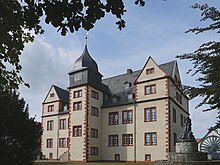
At the beginning of the 17th century, the von Saldern family had to pledge parts of their property. The warlord David Sachse (mid-16th century to 1613) leased part of the property from Wolfenbüttel and built a Renaissance castle here according to the plans of court architect Paul Francke , which was popularly known as the “Saxon Castle” after its builder. Sachse died in 1613 and his daughters sold the castle back to the von Saldern family in 1623. After the Hereditary Prince August Wilhelm acquired the castle in 1695, he had it rebuilt and expanded according to plans by the Brunswick state master builder Hermann Korb . In 1740 Duke Karl I bought the right of use from August Wilhelm's widow and operated the complex as a ducal domain. In 1795 the castle also became the seat of the Lichtenberg / Salder office. After the end of the First World War , the domain became state property and was taken over by the Reichswerke in 1939. The successor of the Reichswerke, then Salzgitter AG , sold the castle in 1954 for the symbolic price of one DM to the city of Salzgitter, which has been using the castle as a municipal museum since 1962.
Open air events are held annually in the castle courtyard during the summer months . The palette ranges from cabaret to concerts with well-known music bands, such as Blackmore's Night , Fury in the Slaughterhouse , Reamonn , Ten Years After and most recently Santiano (2013).
Post mill
The former Osterlinder post mill has been outside of Salder Castle since 1984 . This mill originally stood near the Osterlinde train station . This mill was first mentioned in 1566, in 1770 a Johann Peter Berking from Salder bought the mill together with the Lesser mill. In 1814 the dilapidated mill was rebuilt and in 1878 it was moved closer to a watermill that also belongs to Berking. After further sales, the mill was donated to the city of Salzgitter in 1978, which had it restored with further support. The mill was shown at the Hanover Fair in 1984 and then moved to its current location at the museum.
District court Salder
The Saldersche District Court, which was already responsible for 30 communities in 1850, had its offices in the courthouse of the castle courtyard. Since these were already dilapidated at that time, the domain administration had considered a new building, for which the old courthouse had to give way. The planning for the construction began in 1861, in 1866/67 the building on the road to Heerte (today Richtsweg ) was built and occupied. The building made of sand-lime brick consisted of three parts. In the middle the main building, which housed the service rooms on the ground floor and the magistrate's apartment on the upper floor. The prison was connected to the east and the functional rooms such as the coach house, stable and laundry room to the west. In 1982 the district court relocated to Lebenstedt and the building in Salder was sold. It is now privately owned and has since been extensively renovated.
Association
The sports club VfL Salder eV, founded in 1892, is a traditional club. In addition to the Reitverein Salzgitter eV, there are other associations such as the parents' initiative and the traditional costume group. The THW (Technical Aid Organization), the DRK (German Red Cross) and the ASB (Arbeiter-Samariter-Bund), as well as the volunteer fire brigade founded in 1874, are also stationed in Salder .
Economy and Infrastructure
Agriculture and Forestry
At the time of land consolidation ( separation and coupling), which was carried out in Salder from 1855, the field of Salder comprised around 2500 acres (one acre at that time had 120 square rods of 20.85 m²), so it was around 520 hectares in size. In 2011 the city of Salzgitter stated the total area of Salders to be 817.8 ha, of which 595.8 ha were used for agriculture and 15.8 ha for forestry. The number of farms, of which there were 39 in Salder in 1951, had fallen to 15 by 1975. In 2011 there are only four full-time and one part-time businesses.
In the south-west of the village is the Salder district forester, which manages part of the forests of the nearby Salzgitter ridge.
traffic
Until the 1970s, Bahnhofsstraße was a reminder of the earlier railway connection. Today the district is served by public bus lines. The federal motorway 39 with the junction "Salzgitter-Lebenstedt-Süd / Salzgitter Salder" runs west of the community.
For the development of the postal system in Salder see: Post route Wolfenbüttel-Harzburg .
literature
- Stadtarchiv Salzgitter (ed.): Salder - The history of a village in Salzgitter . Appelhans Braunschweig, Braunschweig 2011, ISBN 978-3-941737-60-0 .
- Jörg Leuschner, Reinhard Försterling, Sigrid Lux: North town in old views - Bruchmachtersen, Engelnstedt, Salder and Lebenstedt . Ed .: Archive of the City of Salzgitter (= contributions to the city's history . Volume 11 ). Salzgitter 1994, DNB 947872485 , p. 161-274 .
- Kathrin Ellwardt: The ev.-luth. Castle Church of St. Maria Magdalena in Salzgitter-Salder . Results of an art historical research. Ed .: Evang.-luth. Parish of Salder. Salzgitter 2001, DNB 961851422 .
- Church buildings in Salzgitter . In: Department for Public Relations of the City of Salzgitter (Ed.): Salzgitter Forum . tape 12 , 1986, DNB 880735341 , p. 62-63 .
Web links
- Literature about Salder in the catalog of the DNB
- Salzgitter-Salder ( Memento from August 16, 2016 in the Internet Archive )
- Municipal Museum Schloss Salder. City of Salzgitter, accessed on February 6, 2014 .
- Church of St. Maria Magdalena in Salder. City of Salzgitter, accessed on February 6, 2014 .
Individual evidence
- ↑ Kirstin Casemir: The place names of the district Wolfenbüttel and the city of Salzgitter (= Lower Saxony place name book . Volume 3 ). Verlag für Regionalgeschichte, 2003, ISBN 3-89534-483-4 , p. 276–278 (At the same time: Diss. University of Göttingen, 2002).
- ↑ Mechthild Wiswe : The field names of the Salzgitter area . Self-published by the Braunschweigischer Geschichtsverein, Braunschweig 1970, DNB 458674877 , p. 479 (At the same time: Diss. University of Göttingen, 1968).
- ↑ Chronik Salder , p. 39
- ↑ Chronik Salder , p. 40
- ↑ Chronik Salder , p. 43
- ↑ Chronicle Salder , p. 61
- ↑ Chronik Salder , p. 101
- ↑ a b Department for Economics and Statistics: Statistical Yearbook of the City of Salzgitter. City of Salzgitter, accessed on February 22, 2020 (total number of eligible residents (main and secondary residence) © City of Salzgitter).
- ^ Department for Economics and Statistics: Monthly Statistical Reports of the City of Salzgitter. City of Salzgitter, accessed on February 22, 2020 (Population at the location of the main residence © City of Salzgitter).
- ↑ Entrance signs for Salder with a new coat of arms , Salzgitter Zeitung of December 17, 2005, p. 25
- ↑ The post mill at the Municipal Museum at Salder Castle. Mühlenvereinigung Niedersachsen - Bremen eV, accessed on February 6, 2014 .
- ↑ On the history of the Osterlinder post mill. City of Salzgitter, accessed on February 6, 2014 .
- ↑ Chronik Salder , p. 310
- ↑ Chronik Salder , pp. 316-318


