
Engerode
|
Engerode
City of Salzgitter
|
|
|---|---|
 |
|
| Height : | 144 m |
| Area : | 95 ha |
| Residents : | 234 (Dec. 31, 2019) |
| Population density : | 246 inhabitants / km² |
| Incorporation : | April 1, 1942 |
| Incorporated into: | Watenstedt-Salzgitter |
| Postal code : | 38229 |
| Area code : | 05341 |
 Location of Engerode in Salzgitter
|
|
 View of Engerode and the St. Marien Church, in the background the Salzgitter AG steelworks
|
|

Engerode is one of the total of 31 districts of the independent city of Salzgitter in Lower Saxony , located in the village of West . Engerode belonged to the Wolfenbüttel district until March 31, 1942 and became part of the city of Watenstedt-Salzgitter through an administrative act on April 1, 1942. On January 23, 1951, it was officially renamed Salzgitter .
history
Engerode was founded in the 8th or 9th century in the area of the Salzgitter ridge. The place is first mentioned in a document from 1234 under the name Oddincherot . The base word of the place name is derived from the personal name Odo or Otto . The place name later changed to Oddingeroht (1236), Oddingerohde (1274), Edding (h) erode (1302), Eddingerode (1361) and in 1542 one finds the current spelling Engerode for the first time in a report about a church visit .
- Note : In the Hildesheim Domnekrolog (anniversary directory of the cathedral chapter) there is a document that is dated to the year 1080 and in which a place Odesrode is listed. Because of the uncertainty both in the dating and the location of the place, an assignment to today's Engerode is rejected.
In the 13th century the lords of Engerode are mentioned. They owned a farm in the village, on which they had a chapel built in 1236. In the 14th century the Ritterhof came into the possession of the Lords of Bortfeld. Later owners were the Lords of Busche (1650 to 1756), the Lords of Brabeck (until 1821) and the Counts of Stolberg until 1840. In 1841 the community acquired the manor and distributed the land among the Brinkitzers of the village.
Engerode has belonged to the Duchy of Braunschweig since the 15th century - initially to the Lichtenberg court and after its dissolution to the Salder court. From 1807 to 1813 Engerode was part of the canton Gebhardshagen in the Braunschweig district in the department of the Oker of the Kingdom of Westphalia . After the Duchy of Brunswick was reintroduced in 1814, Engerode belonged to the Salder district court, later the Salder office, and was incorporated into the Wolfenbüttel district in 1850. Since April 1, 1942, Engerode has belonged to the newly founded town of Watenstedt-Salzgitter - today's Salzgitter.
Ore mining Hannoversche Treue
Engerode changed with the establishment of the Reichswerke Hermann Göring from 1937. Parts of the corridors were needed and bought up for ore mining and its facilities and the farmers were relocated to other places. In the area south of Engerode in the Hannoversche Treue opencast mine, the previously low ore mining output has been significantly increased. In the period from July 1938 to February 1939, the Hannoversche Treue Nord weather shaft was sunk on the western outskirts of Engerode . Three more shafts in the area and the vicinity of the opencast mine ( Hannoversche Treue II, III and South ) were sunk from March 1938 to October 1939.
The operation of the opencast mine was closed in 1948 because the ore deposit was exhausted. The mining of the pits was stopped in May 1967. The city of Salzgitter bought the daytime facilities of the Hannoversche Treue Nord shaft , which are now used by the volunteer fire brigade and the village community.
Population development
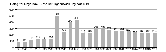
Sources: The population figures from 1821 to 2000 are based on the statistical yearbook of the Department for Economics and Statistics of the city of Salzgitter. The population statistics from 2001 are based on the monthly statistical reports of the city of Salzgitter (residents with main residence) according to the population register at the end of December.
church

The St. Marien Church in Engerode is the oldest church in Salzgitter that is still preserved today. The church is known beyond the borders of Salzgitter for its Gothic vault and wall paintings, in which several paintings depict stations from the life of Christ. The paintings were uncovered during renovation work in 1959/60. Larger parts of the paintings were destroyed during earlier renovations, for example when the windows were enlarged in 1865. The surviving parts nevertheless give an impression of the former complete works.
The church was built in 1236 by the knight Thietmar von Engerode, who founded an Augustinian monastery here and also built a chapel on his knight's court. This connected to the residential tower of the Ritterhof, today's church tower. A short time later the monastery was moved to Wülfinghausen , the church was preserved and developed into a place of pilgrimage. The pilgrims' goal was an image of Our Lady - probably a stone statue. When the pilgrimages to the miraculous image of Mary continued after the final introduction of the Reformation in 1568 by Duke Julius von Braunschweig, the church consistory ordered the removal of the statue of Mary in 1744. This was brought to Söder Castle and is now lost.
At the beginning of the Reformation in 1542, Engerode was still the parish seat. The church in Engerode was part of the archdeaconate grid of the Hildesheim diocese . When the patron saint at the time, Christoph von Bortfeld, had the church property moved in in 1568, the pastor had to leave Engerode and the church was initially looked after from Groß Flöthe . In 1660 the neighboring villages of Gebhardshagen , Calbecht and Engerode founded a parish association to which the parish still belongs today (2018). In the summer of 2017, the three parishes of the parish association merged to form the Gebhardshagen-Calbecht-Engerode parish.
politics
Local council
coat of arms
The curved tip represents the clearing on which Engerode was built. The silver church represents the St. Marien Church in Engerode, one of the oldest pilgrimage churches in the Braunschweig area. The two trees (conifer and deciduous) represent the Engerode location on the border between the Duchy of Braunschweig and the Kingdom of Hanover. It used to be customary to mark borders in wooded areas by planting coniferous and deciduous trees alternately to the border. This different planting can still be found in the Engerode forest today.
The coat of arms was designed by Günther Aust. The coat of arms was adopted as the local coat of arms of Salzgitter-Engerode at a citizens' meeting on October 15, 2003.
literature
- Reinhard Försterling, Sigrid Lux, Gudrun Pischke: Calbecht, Engerode, Gebhardshagen, Heerte . West town in old views. Archive of the City of Salzgitter, Salzgitter 2003, ISBN 3-930292-15-7 , p. 81-126 (Engerode) .
- Claudia Wuttke: Brief history of the Marienkirche in Engerode and its wall paintings . In: Geschichtsverein Salzgitter eV (Ed.): Salzgitter Yearbook 1987 . S. 7-18 .
- Kirstin Casemir: The place names of the Wolfenbüttel district and the city of Salzgitter . Verlag für Regionalgeschichte, 2003, ISBN 3-89534-483-4 , p. 143 f .
- Mechthild Wiswe : The field names of the Salzgitter area . Self-published by the Braunschweigisches Geschichtsverein, 1970, p. 466 f .
- Wolfgang Benz (Ed.): Salzgitter - Past and Present of a German City - 1942–1992 . Verlag CH Beck Munich, 1992, ISBN 3-406-35573-0 , p. 574-588 .
- Four years of Hermann-Göring-Werke Salzgitter 1938–1941, reprint of the anniversary edition from 1941 . Melchior-Verlag Wolfenbüttel, 2009, ISBN 978-3-941555-06-8 , p. 28-57 .
- Literature about Engerode in the catalog of the DNB
Individual evidence
- ^ Försterling, Ortschaft West , p. 81
- ↑ Wiswe, Flurnamen , p. 466f
- ^ Casemir, Place Names , p. 143
- ↑ Wiswe, Flurnamen , p. 466f
- ^ Department for economics and statistics: Statistical yearbook of the city of Salzgitter. City of Salzgitter, accessed on February 22, 2020 (total number of eligible residents (main and secondary residence) © City of Salzgitter).
- ^ Department for Economics and Statistics: Monthly Statistical Reports of the City of Salzgitter. City of Salzgitter, accessed on February 22, 2020 (Population at the location of the main residence © City of Salzgitter).
- ↑ Salzgitter-Zeitung from January 15, 2018
Barum | Condition | Legum | Bleckenstedt | Bruchmachtersen with Sukopsmühle | Calbecht | Drütte | Engelnstedt | Engerode | Flachstöckheim | Gebhardshagen | Grid | Big admonisher | Hallendorf | Army | Hohenrode | Immendorf | Lebenstedt with Fredenberg | Lesse | Lichtenberg with Altenhagen | Lobmachtersen | Ohlendorf with Gut Nienrode and the Schachtsiedlung | Osterlinde | Reppner | Ringelheim | Salder | Salzgitter-Bad | Sauingen | Thiede with Steterburg | Üfingen with Gut Nortenhof | Watenstedt