Ohe (honeycomb)
|
Ohe Destedter Graben, Ohe / Losebach |
||
|
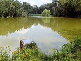
The Veronika lake in the forest area Ohe near Veltheim. |
||
| Data | ||
| Water code | DE : 482882 | |
| location | Germany , Lower Saxony , Wolfenbüttel district | |
| River system | Weser | |
| Drain over | Wabe (Schunter) → Schunter → Oker → Aller → Weser → North Sea | |
| source | Runoff Veronikaee in Veltheim (Ohe) 52 ° 13 ′ 41 ″ N , 10 ° 40 ′ 52 ″ E |
|
| Source height | 120 m above sea level NHN | |
| muzzle | Outdoor pool Sickte Coordinates: 52 ° 13 ′ 1 ″ N , 10 ° 38 ′ 51 ″ E 52 ° 13 ′ 1 ″ N , 10 ° 38 ′ 51 ″ E |
|
| Mouth height | 98 m | |
| Height difference | 22 m | |
| Bottom slope | 5.9 ‰ | |
| length | 3.7 km | |
| Catchment area | 21.81 km² | |
| Left tributaries | Hemkenroder Bach | |
| Right tributaries | Losebach | |
| Flowing lakes | Veronika Lake in Veltheim (Ohe) | |
| Communities | Sank | |
| The NLWKN combines the Ohe with the Losebach to form a body of water with the number 15044. | ||
|
The Ohe bei Sickte, view upstream to the north to the Veltheim forest |
||
The Ohe is a 3.7 km long tributary of the Wabe in the Wolfenbüttel district , which flows through the forest area Ohe in Veltheim (Ohe) and the agricultural Feldmark. The open-air swimming pool in Sickte is located at its mouth . Its beginning is the outflow of Lake Veronica , which is fed by forest streams and the Destedter Graben . The Ohe flows from the Veltheimer Forst towards the Losebach , both bodies of water are considered as one body of water for water monitoring purposes .
geography
The designation Ohe is used in the official maps for the body of water below Lake Veronica in the forest area of Ohe. The lake is fed from the Destedter Graben , which begins south of Destedt at the Hemkenrode open-air swimming pool and flows through the forest as close to nature as possible. He collects other streams from the Hemkenrode area.
The Veronika Lake is an artificially created body of water with a small peninsula, which lies in the depression between Lofkenberg and Papenberg . The final dam is a few meters high. The Ohe strives to the southwest to the Klein Veltheim district, where the street names Vor der Ohe and Am Veronikasee are also used. From here, the Ohe is a largely canalized field ditch that flows west and receives the Losebach coming from the north. This in turn is a confluence of several forest streams in the Veltheimer Forest, whose headwaters reach as far as Schulenrode.
The Ohe bends south and thus in the direction of the river Losebach. Another brook from Veltheim flows in from the left. After a swivel to the southwest, it reaches the area of the Sickte outdoor pool and its ponds, where it flows into the honeycomb flowing from the east.
Water quality
The water body data sheet of the NLWKN with the assessment status from 2012 classifies the water body as a significantly modified water body with regard to the structural quality , for which no target can be achieved under the EU Water Framework Directive by 2015 . The Ohe and the Losebach are regarded as a body of water with the number 15044, which is assigned to type 18 of the loess-loam-shaped lowland brooks. The chemical composition is rated as “good”, in the 2015 data sheet as “bad”, the overall ecological condition in 2012 as “unsatisfactory (4)” and in 2015 as “moderate (3)”. This is mainly due to the structural deficits, which are considerable in some sections, such as straightening, lack of bank vegetation and artificial bed profiles.
Web links
- Map of the Ohe (honeycomb) at openstreetmap.org
- Publications of the state of Lower Saxony on the water quality of the Oker and its tributaries on www.wasserblick.net
- List of water bodies in the Outer catchment area with data Publication by NLWKN on www.wasserblick.net
- Water quality report Oker 2002 Internet platform of the NLWKN
- NLWKN water body data sheet with recommendations for action
Individual evidence
- ↑ a b NLWKN : Water quality report Oker 2002 , Braunschweig October 2002, p. 84 ff., Section Destedter Bach / Ohe
- ↑ a b LGLN : Topographic Map 1: 50,000 , as of 2000, CD-ROM Top50 Viewer
- ↑ a b List of water bodies in the Outer catchment area with data. Retrieved March 2, 2014 .
- ↑ a b NLWKN : Water body data sheet 15044 Ohe / Losebach , as of 2012, NLWKN website on the EU Water Framework Directive, accessed on May 24, 2013.
- ↑ GeoLife. (No longer available online.) Archived from the original on March 19, 2015 ; accessed on March 14, 2015 . Info: The archive link was inserted automatically and has not yet been checked. Please check the original and archive link according to the instructions and then remove this notice.

