Reddeber
|
Reddeber
City of Wernigerode
|
|
|---|---|
| Coordinates: 51 ° 52 ′ 0 ″ N , 10 ° 48 ′ 0 ″ E | |
| Height : | 201 m above sea level NN |
| Area : | 4.76 km² |
| Residents : | 880 (December 31, 2008) |
| Population density : | 185 inhabitants / km² |
| Incorporation : | January 1, 2010 |
| Postal code : | 38855 |
| Area code : | 03943 |
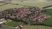
Reddeber is a district of the city of Wernigerode in the Harz district in Saxony-Anhalt .
Geographical location
Reddeber is located in the northern Harz foreland northeast of Wernigerode and can be reached from there via a state road that continues to Minsleben or Heudeber . The town is affected by the new federal highway 6 , which, however, has no exit here.
history
The place was first mentioned in 936 as Rudiburgi by Otto I. However, since a 1000th anniversary celebration had been organized after the Second World War in 1955, the 1050th anniversary of the town was celebrated in 2005. The foundation of the place goes back to a royal court. Emperor Otto III. gave the Rudiburo estate to the church in Halberstadt in the year 1000. In 1120/21 the place was handed over to the Count of Wernigerode. In the first quarter of the 13th century Ridebere went to the Count of Blankenburg-Regenstein as a fief and returned to Wernigerode after the defeat of the Raubgrafen of Regenstein in 1343. In 1531 the village and corridor were separated - the upper and lower courts were assigned to the rule of the Regenstein, but the corridor to the rule of Stolberg-Wernigerode. In 1599, Duke Julius of Braunschweig and Bishop of Halberstadt illegally captured the county of Blankenburg including Reddeber. 1807–1813 Reddeber came to the newly founded Kingdom of Westphalia under Napoleon's brother Jerome after the defeat of Prussia by Napoleon in 1806 . Reddeber specifically belonged to the Saale Department , Landkanton Wernigerode . The Kingdom of Westphalia collapsed again after the French were defeated in the Battle of Leipzig in 1813. From 1816 the administrative district of Magdeburg was divided, Reddeber now belonged to the district of Osterwieck . In 1822 Reddeber was awarded to the Counts of Stolberg and in 1825 came to the re-established County of Wernigerode , which belonged to the Prussian province of Saxony . Reddeber was separated from the Wernigerode corridor in 1870 and again got its own corridor. Around noon on April 11, 1945, US troops occupied the place. It is thanks to two brave inhabitants that the weapons of the Volkssturm did not speak, but a white flag waved.
On January 1, 2010, the previously independent municipality of Reddeber was incorporated into the city of Wernigerode.
badges and flags
The coat of arms was approved on August 30, 1996 by the Magdeburg Regional Council.
Blazon : "A silver grate in red diagonally to the right."
The present coat of arms was designed at the express request of the municipality. It is the grate of St. Laurentius , the namesake of the old church of Reddeber.
The coat of arms was designed by the Magdeburg heraldist Erika Fiedler .
The flag is red and white (1: 1) striped with the coat of arms.
politics
Local Mayor
- Anke Lauing, CDU
Local council
According to the official final result of the local elections on May 26, 2019, the local council consists of the following seats. The turnout was 62.9%. (2014: 44.7%)
- Independent voter community Reddeber - 2 seats
- CDU - 2 seats
- The left one - 1 seat
Memorials
- Burial in the local cemetery for a particularly well-known Polish woman who, during the Second World War deported to Germany and a victim of forced labor was
Personalities
- Ludwig Günther Martini (1647–1719), lawyer and office director of the Counts of Stolberg and landowner in Reddeber, died here.
Individual evidence
- ↑ StBA: Area changes from January 01 to December 31, 2010
- ↑ Announcement of the 2019 election results (PDF) In: wernigerode.de. June 5, 2019, accessed August 28, 2019 .


