Minsleben
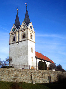
Minsleben has been part of the city of Wernigerode in Saxony-Anhalt since April 1, 1993 .
Geographical location
Minsleben lies on the northern edge of the Harz Mountains in the plain that is open to the north. The Holtemme flows past the village . The Minsleben stop on the Heudeber-Danstedt – Vienenburg railway line has not been served since October 2006. Connecting roads lead from Minsleben to Wernigerode, Reddeber , Heudeber and Silstedt . The dog mill is nearby .
history
The place can look back on over 1000 years of history. There was a noble farm in the village , which was owned by the Reiffenstein family for a long time . The manor house is now partially used as a residential building, the associated landscape park is open to the public. The manor mill can also be visited on certain days.
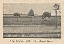
Starting from about the year 1890, a railway worker from Minsleben 89 shrubs and trees has along the railway line in human and animal shapes cut . This became an attraction for the passengers and his work was also disseminated and documented on postcards and in magazines.
From 1936 to 1970, iron ore was mined in the Büchenberg ore mine in Elbingen, seven kilometers away as the crow flies, and transported by cable car into the valley to Minsleben, where it was transferred to rail wagons.
On April 7, 1945, two American fighter-bombers attacked two passenger trains and a freight train carrying concentration camp inmates at Minsleben station. There were 32 fatalities and numerous seriously wounded.
Memorials and monuments
- The village linden on the Krugberg is protected as a natural monument .
- Memorial stone for the 100th birthday of Emperor Wilhelm I.
- Memorial stone for the 32 fatalities of an American bomber attack on three railroad trains in the station area
- Collective burial in the local cemetery , where a name known Belgian is buried, during the Second World War deported to Germany and a victim of forced labor was
swell
- ↑ Federal Statistical Office (Ed.): Municipalities 1994 and their changes since 01.01.1948 in the new federal states . Metzler-Poeschel, Stuttgart 1995, ISBN 3-8246-0321-7 .
- ↑ Page no longer available , search in web archives: Unterwegs, Fall 2006 , page 3.
- ↑ Sochař s nůžkami . In: Světozor . November 11, 1904, p. 116 ( nkp.cz ).
- ↑ http://www.wernigerode-in-jahreszahlen.de/jahr-1945/artikel-584.html
Coordinates: 51 ° 52 ′ N , 10 ° 50 ′ E

