Holtemme
| Holtemme | ||
|
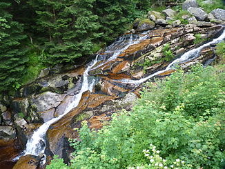
The Steinerne Renne on the upper reaches of the Holtemme |
||
| Data | ||
| location | District of Harz , District of Börde ; Saxony-Anhalt , Germany | |
| River system | Elbe | |
| Drain over | Bode → Saale → Elbe → North Sea | |
| source | between the Renneckenberg and Hohnekamm in the Harz Mountains 51 ° 47 ′ 9 ″ N , 10 ° 39 ′ 51 ″ E |
|
| Source height | approx. 862 m above sea level NHN | |
| muzzle | near Nienhagen in the Bode coordinates: 51 ° 57 '48 " N , 11 ° 10' 59" E 51 ° 57 '48 " N , 11 ° 10' 59" E |
|
| Mouth height | 84.1 m above sea level NHN | |
| Height difference | approx. 777.9 m | |
| Bottom slope | approx. 17 ‰ | |
| length | 47 km | |
| Catchment area | 277.8 km² | |
| Discharge at the Mahndorf A Eo gauge : 168 km² Location: 19.3 km above the mouth |
NNQ (09/10/2012) MNQ 1972–2014 MQ 1972–2014 Mq 1972–2014 MHQ 1972–2014 HHQ (07/18/2002) |
173 l / s 402 l / s 1.33 m³ / s 7.9 l / (s km²) 15.1 m³ / s 56 m³ / s |
| Left tributaries | see below | |
| Right tributaries | see below | |
| Medium-sized cities | Wernigerode , Halberstadt | |
| Small towns | Derenburg , Groeningen | |
The Holtemme is a 47 km long orographic left and southwest tributary of the Bode in the districts of Harz and Börde in Saxony-Anhalt ( Germany ).
etymology
The name Holtemme is a combination of the word stems Holt ( Old Norse for forest-covered hill or originally for a wood) and Emme , which, like the river of the same name, is based on the Gallic-Celtic word ambis (= river, Latin amnis) going back. The etymology shows that alternatively Holle (hill, hill) or wood (from the Germanic Holta (z)) can be considered for the former .
In records and city maps up to the middle of the 18th century, the spelling Holzeme and Holzemme are predominant. At the beginning of the 19th century, the term Holtemme appears on an equal footing. In the pocket book for travelers in the Harz by Friedrich Gottschalck from 1823, under the entry Holzemme, Holtemme, it says: “A river that runs between the Rennekenberg and the ridge of the Hohneklippen, in an extremely wild one hidden between the two mountains The valley, called the Holle, rises from boulders […] ”. Towards the end of the century, the term Holtemme finally caught on, as the entry in the Brockhaus Lexikon from 1910 shows.
course
The Holtemme rises in the resin within the natural parks resin / Saxony-indication in the National Park resin . Its source is in the Harz district between Renneckenberg (approx. 933 m ) and Hohnekamm ( 900.6 m ) at approx. 862 m above sea level. NHN . In 2012 it was marked with an explanatory sign.
First the Holtemme flows in a northerly direction and then bends east of the Renneckenberg to the northeast, in order to turn between the Hohe Wand ( 758 m ; with the Ohrenklippen ) in the north and the Hohnekamm to the east; on Hannekenbruch opens the road Bach and shortly afterwards - after leaving the national park - the Small Holtemme one.
The Holtemme then runs to the northeast, with its water falling into the Steinerne Renne gorge, which has been designated a natural monument, in its steep, granite-cliff-studded creek bed. The Steinerne Renne hydroelectric power station is located roughly at the exit of the gorge . Its turbines are driven by water from the Holtemme flowing through a canal with a pressure pipeline connected to it. At the Steinerne Renne train station there , the Holtemme crosses the track bed of the Harzquerbahn for the first of four times .
Then the Holtemme flows through Hasserode and Wernigerode , where the Zillierbach, known as the flood race, joins not far from the western gate and the Graf-Henrich-Brücke . Below the core town of Wernigerode, it flows past the districts of Reddeber , Minsleben and Silstedt when leaving the Harz Mountains .
After flowing through Derenburg and Tangieren von Mahndorf , where the Holtemme leaves the nature park, it flows through Halberstadt . There the creek was straightened and passed about west to north of the Halberstadt lakes . The Altwasser Alte Holtemme exists south to east of the lakes . Then the flowing water runs through Groß Quenstedt and past Emersleben .
After the Holtemme Nienhagen has passed, leads to about 150 m below the at Groningen belonging cuckoo mill at 84.1 m height in the coming there from the south Saale influx Bode .
Catchment area and tributaries
The catchment area of the Holtemme is 277.8 km². Their tributaries include, with orographic allocation (l = left-hand side; r = right-hand side) viewed downstream:
|
|
Fish death
In November 2019, fish died in the Holtemme near Wernigerode because acidic wastewater from a battery factory ran into the river. Up to 1,500 fish died in the process.
Individual evidence
- ↑ a b c Saxony-Anhalt viewer
-
↑ The Holtemme - Landesanglerverband Sachsen-Anhalt (PDF; 275 kB)
Note: The document differs from the Saxony-Anhalt Viewer : 46 km in length, approx. 745 m height of the source and approx. 86 m of the mouth. - ^ German Hydrological Yearbook Elbe Region, Part I 2014. (PDF) State Office for Flood Protection and Water Management Saxony-Anhalt, p. 213 , accessed on November 3, 2018 (from: lhw.sachsen-anhalt.de).
- ↑ Fish deaths in Wernigerode caused by battery factory. In: mdr.de. November 20, 2019, accessed November 24, 2019 .
Web links
- The Holtemme , on harzlife.de

