
Gasoline electrode
|
Gasoline electrode
City of Wernigerode
Coordinates: 51 ° 50 ′ 4 ″ N , 10 ° 52 ′ 2 ″ E
|
|
|---|---|
| Height : | 215–280 m above sea level NN |
| Incorporation : | April 1, 1993 |
| Postal code : | 38855 |
| Area code : | 03943 |
 Benzingerode, seen from the Austberg Tower
|
|


Benzingerode has been a district of the city of Wernigerode in the Harz district of Saxony-Anhalt since April 1, 1993 .
Geographical location
Benzingerode is located on the northern edge of the Harz , in the transition area to the Harz foreland. It is located about 5.5 km (as the crow flies ) east of Wernigerode, on the old federal road 6 , which runs right through the town and from which a connection road to Silstedt branches off at the eastern end of the town . East of Benzingerode, which is about 215 to 280 m above sea level. NN , the Struvenberg rises , southwest of the Stapenberg and northwest of the Austberg .
history

During the Neolithic the area was populated by groups of people who are assigned to the Bernburg culture , a subgroup of the funnel beaker culture . So-called huts of the dead have been preserved as archaeologically evaluable evidence of these groups . One such was found on the route of the bypass of the newly built federal highway 6n (today's A 36 ) ( see: Totenhütte von Benzingerode ). The place itself can look back on almost 800 years of history. The place name Benzingerode (variations: Benshingerod, Bentsingerod ) is mentioned for the first time in the fiefdom of Count Heinrich I von Regenstein , which records entries from the period from 1212 to 1227. Since it is the oldest part of the Lehnsverzeichnis in which Benzingerode is mentioned, the time of the first mention could be narrowed down to the years 1212/13.
A document dated September 28, 1323 shows that Count Heinrich von Regenstein gave three quarters of land and a farm to Bencingerode to the collegiate chapter of St. Sylvestri in Wernigerode , as his brothers Ulrich and Siegfried did.
The place goes back to two former manors, the Oberhof and the Unterhof. Both names have been preserved as corridor or street names to this day. The Unterhof is said to have been the estate of the Lords of Benzingerode.
Attractions


East of Benzingerode, on the western part of Struvenberg , which belongs to the nature reserve Ziegenberg near Heimburg , are the few remains of the Struvenburg .
To the northwest of the village is the Austberg ( Augsberg / Augstberg ), on which the former Austbergturm ( Austbergwarte ) stands - now used as a lookout tower. From there, you can see, among other things, Benzingerode, the Harz Mountains and the Harz foreland.
The neo-Romanesque village church Benzingerode in the center of the village was built in 1903.
There is also a school museum in town.
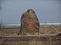
Furthermore, there are three menhirs to the northeast of Benzingerode ( menhir from Benzingerode , menhir from Derenburg and menhir from Heimburg ). These are located in a field not far from the newly built federal highway 6 and can be reached via the 6 km long menhir circular route. The "large" menhir (3.50 m) still stands at its original location, while the other two menhirs were recently rebuilt in more or less original locations.

Menhir from Benzingerode

Menhir of Derenburg
Menhir from Heimburg


Sons and daughters of the place
- Philipp Wilhelm Oeding (1697–1781), painter and miniaturist
literature
- Johann Christoph Stübner: Memories of the Principality of Blankenburg and the same incorporated Walkenried Abbey , Wernigerode 1788–1790.
Web links
Individual evidence
- ↑ Federal Statistical Office (Ed.): Municipalities 1994 and their changes since 01.01.1948 in the new federal states . Metzler-Poeschel, Stuttgart 1995, ISBN 3-8246-0321-7 .
- ↑ Saxony-Anhalt Viewer
Benzingerode | Minsleben | Reddeber | Schierke | Silstedt | Wernigerode