Hainberg (mountain range)
| Hainberg | ||
|---|---|---|
| Highest peak | Kalter Buschkopf ( 299 m above sea level ) | |
| location | Districts of Goslar , Hildesheim , Wolfenbüttel ; Lower Saxony ( Germany ) | |
| part of | Lower Saxony highlands | |
|
|
||
| Coordinates | 52 ° 2 ' N , 10 ° 13' E | |

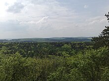
The Hainberg (popularly known as the Hainberge due to its several mountain peaks , also outdated Heinberg ) in the Lower Saxony districts of Goslar , Hildesheim , Wolfenbüttel is up to 299 m above sea level. NHN high mountain range of the Lower Saxony mountains .
geography
location
The Hainberg spreads in the center of the Innerstebergland , a north-eastern part of the Lower Saxon mountainous region . It is located northwest of the Harz low mountain range , a few kilometers southwest of Salzgitter and delimits the Ambergau to the east. The ridge is located between the Salzgitter ridge (with the Lichtenberg mountains ) in the north, northeast and east and the Vorholz ridge in the north-northwest. It extends from Holle in the north-north-west and Baddeckestedt in the north and east to Lutter am Barenberge in the south. West of the Hainberg is Bockenem in the center of the Ambergau. Past the ridge flow the Innerste in the east, the Neile in the southeast and the Nette in the west, which are fed by some streams of the ridge - for example from the Nette tributaries Beffer and Sennebach .
Natural allocation
The Hainberg forms the natural area Hainberg (379.20) in the main natural unit group Weser-Leine-Bergland (No. 37), in the main unit Innerstebergland (379) and in the subunit Ringelheimer Bergland (379.2).
Surveys
The elevations of the Hainberg include - sorted by height in meters (m) above sea level (MSL; unless otherwise stated according to):
|
|
Localities
Localities on the Hainberg are:
|
|
Protected areas
On the Hainberg are parts of the conservation area (LSG) Hainberg, Wohldenberg, Brown heath, small Rhüdener timber and adjacent parts of the landscape ( CDDA -No 321 317;. 1975; 23.84 square kilometers ) and to the west thereof is the LSG Hainberg (CDDA no. 321316; 2002; 29.5 km²). Parts of the first-mentioned LSG are designated as the Hainberg fauna-flora-habitat area (FFH no. 3927-301; 11.91 km²). In addition, elongated parts of the FFH area Nette and Sennebach (FFH No. 3926-331; 2.9205 km²) run through the ridge as a narrow band .
Attractions
Among the sights of the Hainberg are the Bodensteiner cliffs , which are located at about 200 to 283 m above sea level, are made of Hils sandstone from the Lower Cretaceous and extend for about three to four kilometers through the southern part of the ridge. These are locally stronger solidified areas that have been prepared by weathering.
To the north of the cliffs is the Hubertus Chapel (Hubertusgrotte) , a rock chapel carved in sandstone in 1733. The Jägerhaus , built in 1838 and used as a forest restaurant, is located in its northern neighborhood .
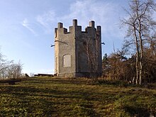
From the Jägerturm on the northern Jägerturmskopf ( 244 m ) there is a view of the Harz Mountains to the south and south-east. On the Wohldenberg ( 218 m ) located in the northwestern foothills of the Hainberg stands the Wohldenberg Castle , whose keep serves as a lookout tower.
Traffic and walking
A section of the federal highway 7 runs through the northwestern foothills of the Hainberg, to the northeast passes one of the federal highway 6 in a northwest-southeast direction and to the southeast the ridge becomes a section of the federal highway 248 in a southwest-northeast direction affects. The ridge is criss-crossed by several hiking and forest trails .
Individual evidence
- ↑ a b c Map services of the Federal Agency for Nature Conservation ( information )
- ↑ a b c d e Berghöhe - various mountains according to the topographical overview map of the Harz Mountains ( memento of the original from December 19, 2014 in the Internet Archive ) Info: The archive link was inserted automatically and has not yet been checked. Please check the original and archive link according to the instructions and then remove this notice. (DTK 25; see large enlargement of the map), on natur-erleben.niedersachsen.de
- ↑ Berghöhe - according to Der Große Falk Atlas - Germany detailed maps , M = 1: 200,000, 2004/2005, ISBN 9783827903815
- ↑ Jürgen Vespermann: The Bodensteiner cliffs in the Hainberg near Bodenstein , pp. 161-163 in: Fritz J. Krüger (Ed.): Walks in the Earth History, Volume 19, Braunschweiger Land . Publishing house Dr. Friedrich Pfeil, Munich 2006, ISBN 3-89937-066-X


