Neile
| Neile | ||
|
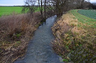
The Neile in Wallmoden just above the confluence of the Kirschensoog drain |
||
| Data | ||
| Water code | DE : 48862 | |
| location | Lower Saxony , Germany | |
| River system | Weser | |
| Drain over | Innerste → Leine → Aller → Weser → North Sea | |
| source | at the foot of the Hohestein 51 ° 54 ′ 46 ″ N , 10 ° 14 ′ 53 ″ E |
|
| Source height | approx. 530 m above sea level NHN | |
| muzzle | at Alt Wallmoden in the innermost coordinates: 52 ° 2 ′ 0 ″ N , 10 ° 17 ′ 10 ″ E 52 ° 2 ′ 0 ″ N , 10 ° 17 ′ 10 ″ E |
|
| Mouth height | approx. 120 m above sea level NHN | |
| Height difference | approx. 410 m | |
| Bottom slope | approx. 24 ‰ | |
| length | 17 km | |
| Catchment area | 65.63 km² | |
The Neile is a 17 km long left tributary of the Innerste in Lower Saxony . It drains the Lutter basin in particular .
course
It rises in the Harz at the foot of the Hohestein about 2 km west of the Innerste dam . At Hahausen it leaves the forest area and reaches the Harz foreland . In Neuwallmoden, the Neile passes the narrower Neiletal and its water is strengthened shortly afterwards by the Kirschensoog , a periodic karst spring . This is located in the immediate vicinity of the neil bed and can pour out up to 950 liters per second in heavy rain events. On the border of the district of Goslar , the exclave of the district of Wolfenbüttel and Salzgitter , the Neile flows into the Innerste .
Tributaries
- Mittelbach (left)
- Hummecke (right)
- Steimker Bach (right)
- Pagenbergsbach (right)
- Bach from the Kirschensoog (right, temporarily dry)
Individual evidence
- ↑ a b State Office for Geoinformation and Land Surveying Lower Saxony: Top 50 - Topographic Map 1: 50,000 Lower Saxony / Bremen , as of 2000.
- ↑ a b Table_03_ Auflistung__Wasserkoerper_041222. (PDF) www.waasserblick.net/ NLWKN , December 8, 2006, accessed on May 2, 2020 .
- ^ Area directory / Weser (PDF; 13 MB), Geosum
- ↑ Lutter and the waters of the Harz, p. 4


