
Innerste dam
| Innerste dam | |||||
|---|---|---|---|---|---|
 |
|||||
|
|||||
|
|||||
| Coordinates | 51 ° 54 ′ 41 ″ N , 10 ° 17 ′ 3 ″ E | ||||
| Data on the structure | |||||
| Construction time: | 1963-1966 | ||||
| Height above valley floor: | 32 m | ||||
| Height above foundation level : | 40 m | ||||
| Height of the structure crown: | 264.00 m above sea level | ||||
| Building volume: | 850,000 m³ | ||||
| Crown length: | 750 m | ||||
| Crown width: | 8.0 m | ||||
| Slope slope on the air side : | 1: 1.50 1: 2.00 | ||||
| Slope slope on the water side : | 1: 1.75 | ||||
| Data on the reservoir | |||||
| Altitude (at congestion destination ) | 261 m | ||||
| Water surface | 139 ha | ||||
| Storage space | 19.26 million m³ | ||||
| Catchment area | 97 km² | ||||

The Innerste dam is a dam of the Innerste , which is located near Langelsheim and Wolfshagen in the Harz Mountains . It was built from 1963 to 1966 and belongs to the Harz waterworks . Their purpose is drinking water supply , flood protection , low water elevation and power generation. The mean annual discharge of the Innerste dam is 60 million m³.
Buildings
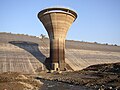
The dam of the Innerstetalsperre is an earth dam with a multi-layered asphalt concrete seal on the outside. He has an inspection corridor in the water-side hearth wall over the entire length . In front of the foot of the dam on the water side there is a flood overflow tower , in which the bottom outlet is also integrated. The water from the Innerste dam can be pumped through a 4.6 km long pressure line to the east Granetalsperre , where it can be used for drinking water treatment. From 2003 to 2005, the dam was completely emptied and, in particular, the asphalt seal and the bottom outlet were renovated; the construction work was completed in September 2005.
Others
Since the dam has only a small degree of expansion (i.e. the storage volume is relatively small in relation to the annual inflow), it can only absorb floods to a limited extent . The flood relief system (overflow) goes into operation about every two years. Nevertheless, thanks to the retention , the floods are significantly dampened and delayed even if the Innerste dam is overflowing.
The reservoir can be used with sailing and rowing boats and for fishing and camping.
The Innerstetalbahn is a former railway line that had a stop at the Innerstetalsperre. It originally ran down through the valley, but was then moved to the eastern slope for the construction of the Innerste dam. Since the railway line was only allowed to climb to a limited extent from Langelsheim, the height to be achieved up to the barrier was also the limit for the maximum height of the dam. A bicycle path now runs along the route between Langelsheim and Wildemann .
Fish fauna
The water in the Innerste dam is cold and soft and poor in nutrients. Lead fish are salmonids such as brown trout and lake trout . There are also pike , perch , carp and tench , as well as various white fish species . After the renovation work in 2003, the fish population was completely rebuilt through stocking measures.
Picture gallery

Overflow tower in the reservoir
Overflow tower during renovation work
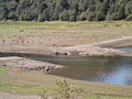
Storage space when the water level is low
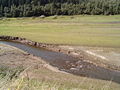
Inside the storage space when the water level is low
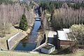
Drainage below the dam. On the right the pumping station to the Granetalsperre


See also
Individual evidence
literature
- Martin Schmidt : Dams in the Harz. East and West Harz. 9th edition, updated by Rainer Tonn. Papierflieger Verlag GmbH, Clausthal-Zellerfeld 2012, ISBN 978-3-86948-251-4
- Peter Franke, Wolfgang Frey: Dams in the Federal Republic of Germany . Systemdruck, Berlin 1987, ISBN 3-926520-00-0 .
Web links
- Harzwasserwerke.de with a link to current dam data