
Granetalsperre
| Granetalsperre | |||||||
|---|---|---|---|---|---|---|---|
 |
|||||||
|
|||||||
|
|||||||
| Coordinates | 51 ° 54 '32 " N , 10 ° 22' 28" E | ||||||
| Data on the structure | |||||||
| Construction time: | 1966-1969 | ||||||
| Height above valley floor: | 62 m | ||||||
| Height above foundation level : | 67 m | ||||||
| Height of the structure crown: | 313 m above sea level NN | ||||||
| Building volume: | 1.8 million m³ | ||||||
| Crown length: | 600 m | ||||||
| Crown width: | 8 m | ||||||
| Base width: | 234 m | ||||||
| Slope slope on the air side : | 1: 1.50 / 1: 1.75 / 1: 2.00 | ||||||
| Slope slope on the water side : | 1: 1.75 | ||||||
| Power plant output: | 180 kW | ||||||
| Data on the reservoir | |||||||
| Altitude (at congestion destination ) | 311 m above sea level NN | ||||||
| Water surface | 2.19 km² (219 ha) | ||||||
| Storage space | 46.4 million m³ | ||||||
| Catchment area | 23 km² (Granesystem) , 234 km² (with transitions) |
||||||
| Design flood : | 70 m³ / s | ||||||
 |
|||||||

The Granetalsperre is a reservoir of the Grane in the Harz Mountains . It is located in the Lower Saxony district of Goslar near the Astfeld district of Langelsheim .
The dam , which was built from 1966 to 1969 and operated by the Harz waterworks , is used to supply drinking water , protect against flooding , raise low water levels and generate energy . It is the youngest dam in the Harz Mountains .
geography
location
The Granetalsperre is located in the Harz Nature Park . Your dam is located in the valley of the Innerste tributary Grane, south-south-west above the Herzog Juliushütte district, which is part of the Astfeld district of Langelsheim . The dam is located in the Harz landscape protection area (district of Goslar) ( CDDA no. 321402; 2001 designated; 389.75 km² ).
Natural allocation
The Granetalsperre is located in the natural spatial main unit group Harz (No. 38), in the main unit Upper Harz (380) and in the sub-unit Goslarer Bergland (380.2) in the natural areas of Gosebergland (380.21; East Arm) and Wolfshagen Basin (380.20; West Arm ).
From the dam to the north, the landscape leads along the Grane into the Innerste mulde natural area (379.28), which is part of the main unit group Weser-Leine-Bergland (37) and the main unit Innerstebergland (379) to the sub-unit Ringelheimer Bergland (379.2).
dam
The dam was backfilled from 1966 to 1969. It is 62 m high above the valley floor and 67 m above the foundation floor. The dam is 600 m long and 8 m wide at the crown, which is 313 m high; at its base it is 234 m wide. The dam consists of 1.8 million m³ of earth material and it has an asphalt concrete outer seal.
Reservoir
The reservoir has a surface of 2.19 km² (= 219 ha). Its storage space can hold 46.4 million m³ of water. The target is at a height of 311 m . The unaffected catchment area of the Granesystem is 23 km²; Due to the transfer tunnels from neighboring areas , the catchment area has a total area of 234 km².
The main tributary of the reservoir is the Grane, which feeds the narrower east arm, and the longer Varley and the shorter Wiehnbach feed the wider west arm. The Lütjenberg ( 387 m ) rises between these main arms . Northeast of the reservoir is the Nordberg ( 457.5 m ) and north of the Todberg ( 367.2 m ) with a dam between the two.
Waterworks
The waterworks for the drinking water supply is raised on the northern slope. For this purpose, the water is pumped up from the dam into an equalization storage basin of 60,000 m³ storage space, from where it flows to the waterworks for treatment. The hydropower plant , which went into operation in 1972, has an output of 180 kW. The Granetalsperre has an average annual discharge of 55 million m³.
Transfer tunnel
Because the Grane itself does not carry enough water for the drinking water supply due to its small catchment area , the 7.4 km long Oker-Grane tunnel was excavated , which branches off from the Oker in Romkerhalle below the Okertalsperre and leads northwest to the Granetalsperre. This also takes in water from the Gose and the Wintertalbach along the way. In his inlet structure in Romkerhalle he can also record the water of the Great Romke , into which flows about 1000 meters above the 4.8 km long Radau tunnel , which takes water from the Radau from certain water channels.
Furthermore, there is a 4.6 km long DN 1200 pipeline from the Innerste dam to the Varley valley, which can supply up to 2.0 m³ / s of water from the Innerste area of the Grane dam by means of two 1,000 kW pumps to further increase the water supply. Since the water has to be pumped over a 100 meter high mountain, this maintenance is relatively energy-intensive, which is why the pumps are only switched on when the water supply in the Granetalsperre becomes scarce.
fauna
The Granetalsperre is one of the Braunschweiger Fischer e. V. cherished salmonid water with large brook , rainbow and lake trout , where only fly fishing and fishing with all kinds of artificial bait is permitted for a limited number of annual tickets. The dam is also known for its catches of capital perch . Since the water protection area is actually not allowed to be entered, the anglers must be able to show a special permit which is preceded by instruction.
The area around the dam and storage space is still populated by the adder , which has become very rare in the Goslar district .
Leisure and hiking
Since the reservoir is used to produce drinking water, water sports such as sailing or surfing are prohibited on it. Car traffic is also kept away from him. A forest road was laid out around the lake to develop the forest areas, which is open to hikers and cyclists and is 14.5 km long. The dam is included as no. 110 in the system of stamping points of the Harz hiking pin; the stamping point is to the east above a bay.
Picture gallery

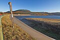
Confluence (left) of the Grane into the reservoir; on the right in the background the Königsberg
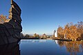
Waterside embankment of the dam with asphalt seal

View of the waterworks
Well system in front of the waterworks

Pumping station

Inside view of the pumping station

Access tunnel under the dam

Inspection passage under the dam


See also
literature
- Martin Schmidt : Dams in the Harz. East and West Harz. 9th edition, updated by Rainer Tonn. Papierflieger Verlag GmbH, Clausthal-Zellerfeld 2012, ISBN 978-3-86948-251-4
- Peter Franke, Wolfgang Frey: Dams in the Federal Republic of Germany . Systemdruck, Berlin 1987, ISBN 3-926520-00-0 .
Web links
- Granetalsperre (main page), on harzwasserwerke.de
Individual evidence
- ↑ a b c d e f g h i The Granetalsperre (main page), on harzwasserwerke.de
- ↑ a b c d e f g h i j k l m n o p q r s The Granetalsperre (Flyer), on harzwasserwerke.de (PDF; 525.3 kB)
- ↑ Map services of the Federal Agency for Nature Conservation ( information )
- ↑ Jürgen Spönemann: Geographical Land Survey: The natural spatial units on sheet 100 Halberstadt. Federal Institute for Regional Studies, Bad Godesberg 1970. → Online map (PDF; 4.7 MB)
- ↑ Justus Teicke: Flood protection for Goslar, a discharge point on the Wintertalbach im Bergtal , Goslarer Bergkalender , 2015, Verlag Goslarsche Zeitung Karl Krause, Goslar 2014
-
^ Club Braunschweiger Fischer e. V. , accessed on December 2, 2015, on klubbraunschweigerfischer.de;
see there also: The Granetalsperre in the Harz Mountains - ↑ Blinker 6/2001, pp. 21-25
- ^ Amphibians and reptiles in the district , Seesener Beobachter, from June 13, 2013, accessed on January 9, 2017
- ↑ Granetalsperre circular hiking trail , accessed on August 15, 2016, at outdooractive.com
- ↑ Harzer Wanderadel: stamp point 110 / Granestausee , on harzer-wandernadel.de