Grane (river)
| Grane | ||
|
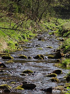
The grane before entering the reservoir. |
||
| Data | ||
| Water code | DE : 488618 | |
| location | In the district of Goslar | |
| River system | Weser | |
| Drain over | Innerste → Leine → Aller → Weser → North Sea | |
| source | At Hahnenklee in the Upper Harz | |
| Source height | approx. 540 m above sea level NN | |
| muzzle | At Langelsheim in the innermost coordinates: 51 ° 56 '18 " N , 10 ° 20' 42" E 51 ° 56 '18 " N , 10 ° 20' 42" E |
|
| Mouth height | 194 m above sea level NN | |
| Height difference | approx. 346 m | |
| Bottom slope | approx. 39 ‰ | |
| length | 8.9 km | |
| Catchment area | 45.07 km² | |
| Left tributaries | Varleybach, Töllebach | |
| Reservoirs flowed through | Granestausee | |
| Small towns | Langelsheim | |
| Communities | Herzog Juliushütte , Astfeld | |
The Grane is a right tributary of the Innerste west and northwest of Goslar .
It rises near Hahnenklee in the Upper Harz and flows into the Innerste approx. 12 km later at Langelsheim . In Herzog Juliushütte , municipality of Astfeld near Goslar, it is dammed to form the Granetalsperre .
Its catchment area is around 45 km², 22 of which are up to the dam.
Postcard batch in Granethal around 1900 by Karl Friedrich Wunder
Around 1900: deforestation , soil erosion and two watercourses in the former Granethal (near the hunting lodge); Postcard from Karl Friedrich Wunder
Individual evidence
- ↑ a b State Office for Geoinformation and Land Surveying Lower Saxony: Top 50 - Topographic Map 1: 50,000 Lower Saxony / Bremen , as of 2000.
- ↑ NLWKN : Inventory of the implementation of the EC Water Framework Directive, processing area Innerste , Braunschweig November 2004, Table 3, added WK 20037 and 20043.
- ↑ a b Area Directory / Weser (PDF; 13 MB), Geosum


