
Bärenbrucher pond
| Bärenbrucher pond | |||||||||
|---|---|---|---|---|---|---|---|---|---|
 |
|||||||||
|
|||||||||
|
|||||||||
| Coordinates | 51 ° 46 '39 " N , 10 ° 21' 6" E | ||||||||
| Data on the structure | |||||||||
| Lock type: | dam | ||||||||
| Construction time: | before 1634 | ||||||||
| Height above valley floor: | 7.09 m | ||||||||
| Height above the river bed : | 7 m | ||||||||
| Height of the structure crown: | 559.4 m | ||||||||
| Operator: | Harz waterworks | ||||||||
| Data on the reservoir | |||||||||
| Water surface | 5.6 ha | ||||||||
| Total storage space : | 186 000 m³ | ||||||||

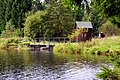
The Bärenbrucher pond in the Harz Mountains is a historic reservoir near Buntenbock in the Goslar district in Lower Saxony . It is one of the Upper Harz ponds that were created for the energy supply of Upper Harz mines .
description
The Bärenbrucher pond is located in the Upper Harz in the Harz Nature Park . It is located 1.25 km east of Buntenbock, a district of Clausthal-Zellerfeld . The upper reaches of the innermost flow through it . The water surface is 559.4 m above sea level. NHN and its storage volume is 186,000 m³. The dam is around 7 m high.
The history of the Bärenbrucher pond can be traced back to 1634.
The water from the Bärenbrucher Pond can be fed via the Bärenbrucher watercourse created in 1948 via a chain of six watercourses and intermediate sections of ditches to the Rosenhof, where it was used to generate energy in the Rosenhof pit and later in the Ottiliaeschacht power plant. Another option is the regular bottom outlet, which releases the water into the Ziegenberger pond located immediately below . Today the Bärenbrucher pond is normally operated as an overflow pond, that is, the bottom outlets are closed and the inflowing water flows over the overflow into the Ziegenberger pond .
The storage space is used by the sport fishing association Oberharz eV and the interest group Harzgewässer eV as fishing waters. Boat fishing is not allowed.
In a refuge at the southern end of the dam there is stamp number 137 of the Harz hiking pin .
Picture gallery

In the evening at the Bärenbrucher pond, November 2007
Flood relief system ; the hut is an entrance to the Bärenbrucher watercourse

Bärenbrucher pond, September 2010

Bärenbrucher pond around 1900


See also
Web links
- Bärenbrucher pond water profile, on anglermap.de
Individual evidence
- ↑ Map services of the Federal Agency for Nature Conservation ( information )
- ↑ Harzer Wanderadel: stamp point 137 / Bärenbrucher Teich , on harzer-wandernadel.de