Swamp pond
| Swamp pond | |||||||||
|---|---|---|---|---|---|---|---|---|---|
| Swamp pond with dam from the southeast, Buntenbock in the background, February 2008 | |||||||||
|
|||||||||
|
|
|||||||||
| Coordinates | 51 ° 46 '45 " N , 10 ° 20' 13" E | ||||||||
| Data on the structure | |||||||||
| Lock type: | dam | ||||||||
| Construction time: | before 1639 | ||||||||
| Height above valley floor: | 6.91 m | ||||||||
| Data on the reservoir | |||||||||
| Total storage space : | 189 000 m³ | ||||||||
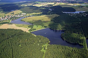
| Aerial view of the Buntenbock pond landscape: Ziegenberger pond (front) and swamp pond (left, back) | |||||||||
The swamp pond is an artificially created reservoir east of Buntenbock near Clausthal-Zellerfeld . It is one of the Upper Harz ponds that have been created for Montanz purposes.
description
The swamp pond is the fourth barrage of the innermost , has a storage volume of 189,000 cubic meters , and its dam is almost seven meters high. It is located directly on the edge of the town.
The history of the swamp pond can be traced back to 1639. With the recognition of the structures of the Upper Harz Water Regiment as a World Heritage Site , the swamp pond is now also part of the UNESCO- awarded monument ensemble.
See also
Web links
Commons : Buntenbock Buntenbock - Collection of images, videos and audio files


