
Lautenthal
|
Bergstadt Lautenthal
City of Langelsheim
|
|
|---|---|
![Coat of arms of Bergstadt Lautenthal [1]](https://de.wikipedia.org/wiki/Datei:Wappen_der_Bergstadt_Lautenthal.svg) |
|
| Height : | 299 m above sea level NN |
| Residents : | 1513 (June 30, 2019) |
| Incorporation : | July 1, 1972 |
| Postal code : | 38685 |
| Area code : | 05325 |
 View to the city center
|
|
The Lautenthal district is a state-approved climatic health resort that has belonged to the town of Langelsheim in the Goslar district in Lower Saxony since 1972 and has been officially known as " Bergstadt " since 2013 . In addition to the core town, Lautenthal consists of the settlements Laddeken, Rote Klippe and Hüttschenthal .
geography

Lautenthal is located in the Innerstetal between Clausthal-Zellerfeld and Langelsheim in the north-western Upper Harz . The place is at an altitude of about 300 m above sea level. NN in a basin, with the surrounding mountains heights up to 620 m above sea level. Reach NN . The two rivers Innerste and Laute flow through the mountain town. In the direction of Langelsheim the Innerste is dammed to the Innerste dam.
history
Around 1225 the mining of silver, lead and copper began on the 557 m high Kranichsberg. Around 1330 there were several copper mines in the area where Lautenthal is today. This first form of mining came to a standstill when the Harz was depopulated during the plague epidemic from 1348 to 1350. Afterwards the Harz was largely uninhabited for almost 200 years.
In 1524, Duke Heinrich the Younger of Braunschweig-Wolfenbüttel started mining again and settled miners from the Ore Mountains in the valley of the Innerste and the Lute. In this way Lautenthal was founded as a miners' settlement in 1538 and elevated to a town in 1580. The establishment of the place was connected with the discovery of iron ore in the upper tunnel on the Gramsberge by a miner named Kaspar Bitter, after whom one of Lautenthal's most important streets is named today. When he reported his find to Duke Heinrich the Younger, he left him some intraden (income) from the Liebenburg office . 16 years later Lautenthal became a free mining town , the inhabitants of which were exempt from certain taxes and from military service. As a result, the town's population increased rapidly.
Lautenthal was initially an elongated street market in the valley of the Laute along today's Hahnenkleer Straße, the oldest street in the city. Around 1560, the city was expanded to the north as planned, with today's square market square being laid out. In 1570 the town hall, still preserved today, was built there. In 1561 the construction of the church began, which three years later made it possible to worship in the village. At that time Lautenthal did not have a pastor of his own, they came from the surrounding villages. It was not until 1577 that Jacob Bitter became the first pastor to reside in the village, who held his office until 1607. In 1577 Lautenthal escaped the plague-like epidemic that raged in the Harz Mountains at that time and killed almost 2,600 people in Goslar in 1578, for example , the place was hit by another wave of plagues during the Thirty Years' War in 1625 , which killed more than 500 people. In 1603, Duke Heinrich Julius gave the city its own coat of arms and seal. On March 22, 1626, the city was sacked during the Thirty Years War by the troops of Johann T'Serclaes von Tilly . Construction of today's Paul Gerhardt Church began in 1649. It was inaugurated on July 16, 1659.
In the years from 1669 to 1672 the Harz was hit by a great drought, so that the lute dried out at times and the mining in Lautenthal had to be stopped for some time.
Several times in Lautenthal damage was caused by flooding of the innermost and / or the lute. B. 1572, 1774, 1861, 1877, 1888, 1925 and 1932.
In 1690 there were 28 ore mines in operation in and around Lautenthal, and in 1740 there were 35. Around the middle of the 18th century Lautenthal experienced an economic boom due to abundant silver ore discoveries and in 1750 had a population of around 3,000. In 1821 the city had a population of 2006. A smelter for processing the ore mined in Lautenthal was founded in 1873. The city was connected to the railway network in 1875 when the Innerstetalbahn to Lautenthal was completed. The station building, not far southwest of the city, 305 m above sea level. Located in the NN , it was only inaugurated in 1877.
At the beginning of the 20th century Lautenthal had 2626 inhabitants.
At the end of the Second World War , a total of seven houses in Lautenthal were destroyed by artillery fire on April 11 and 12, 1945.
With the cessation of mining in 1959 and the closure of the silver smelter in 1967, the city lost its importance and was incorporated into Langelsheim on July 1, 1972. In 1976 the Innerstetalbahn, which had connected Lautenthal to the railway network, was shut down.
With effect from August 27, 2013, the district was given the official historical designation "Bergstadt", but this has no effect on the affiliation to the city of Langelsheim.
Population numbers
1810: 1831
1813: 2133
1821: 2006
1852: 2279
1864: 2287
1890: 2702
1910: 2490
1916: 2155
1917: 2009
1919: 2265
1925: 2645
1933: 2750
1939: 2305
politics
(2011: 49.61%)
Local council
After the local elections on September 11, 2016, the local council consists of (changes to 2011):
Local mayor
The local mayor is Hartmut Arndt (CDU).
Culture and sights
Lautenthal is surrounded by two cross-country skiing trails and many hiking trails, which can be used to reach sights in the area such as the Innerstalsperre , including the Harzer Försterstieg . There is a mining educational trail .

Market square with Koehlerhütte

Hahnenkleer Strasse

Smallest house in the West Harz in the street "An der Laute"
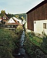
The lute in the center of the village

Former train station

Railway bridge of the former Innerstetalbahn at the confluence of the Laute in the Innerste


Buildings
- The Paul Gerhardt Church, visible from afar, on a mountain spur just above the market square was built in 1649–1659. Inside, the pulpit altar and the organ from 1719 are particularly worth seeing.
- The bell tower from 1670 rises above the church.
- The former town hall, built in 1570 and converted into a hotel in 1658, is located on the market square, which was laid out around 1560 and in the middle of which is a reconstructed Köhler hut in the original style. In 1784 Johann Wolfgang von Goethe stayed here , in 1862 King George V of Hanover .
- The “smallest house in the West Harz”, on An der Laute street in the old town center, is another well-known building in Lautenthal.
- The former station building opened in 1877 was converted into a hotel after the railway line was closed.
- The milestone (Lautenthal) dates from the 19th century.
Museums
The mining museum, open all year round, is located on the site of the former Lautenthals Glück silver mine . It is located on an approximately 500 m long site on the road to Wildemann . The entrance building is a replica of the shaft tower of the Duke Johann Friedrich shaft in Bockswiese , the upper part of which has since been damaged . The museum offers entry into the mine with a mine train, an open-air museum with mining technology and around 30 historical mine locomotives, the use of a boat line underground, the St. Barbara chapel at a depth of 266 m as well as exhibits on historical mining technology, such as driving art equipment and an artificial bike , a Steigerhaus and a silver hut.
Another museum is the Heimatstube in the old school on the market square.
At times, a brewery museum was operated in the historic brewery around 1600. The art of brewing began in 1660 and ended in 1959/60 with the discontinuation of the "dwarf brew".

Shield for the former city law

Today mining museum, formerly Lautenthals Glück silver mine

Mine car of the mine
_IMG_5553.jpg)

_IMG_5561.jpg)
music
The Lautenthal hut music corps, the Fortuna men's choir and the Lautenthal mandolin club from 1920 are the musical cultural bearers of the community. Guntram Hecht , music teacher , organist and composer , held the office of organist in Lautenthal for many years.
societies
At the moment (2010) there are 32 clubs and organizations in Lautenthal.
Regular events
The Easter bonfire is always held on the Saturday before Easter on the Kranichsberg and the traditional mountain town festival takes place on the last weekend in June.
Economy and Infrastructure
traffic
Local public transport buses run from Lautenthal to Goslar , Clausthal-Zellerfeld or Altenau and Hahnenklee . The Innerstetalbahn trains stopped at the former Lautenthal station until 1976 . The former railway line is still clearly visible and can be used today as a hiking and cycling path or ski trail in winter. Today, the next one is Railway - access site of Langelsheim Station .
Public facilities
There is the Bürgerbad in the mountain town of Lautenthal, the Lautenthal Tourist Information Center and the Kurpark. Lautenthal has a primary school and a kindergarten. The Kurhaus with the gastronomic part was demolished.
Personalities
- Walter Wessel (1892–1943), Lieutenant General in World War II
literature
- Paul Ernst : The luck of Lautenthal . Albert Langen / Georg Müller, Munich 1940.
Web links
- Official homepage of the Bergstadt Lautenthal e. V.
- Homepage of the formerly free mountain town of Lautenthal in the Upper Harz ( Memento from August 1, 2015 in the Internet Archive )
Individual evidence
- ↑ a b Decision on the award of the historic title of Bergstadt by the State of Lower Saxony. (PDF) niedersachsen.de, p. 639
- ↑ District of Goslar (PDF) accessed on January 13, 2020.
- ↑ Evert Heusinkveld: The Innerstetal train Langelsheim - Altenau . Nordhorn 2007, p. 64
- ↑ G. Ulrich Großmann: Hanover and South Lower Saxony . Cologne 1999, p. 187
- ↑ G. Ulrich Großmann: Hanover and South Lower Saxony . Cologne 1999, p. 188
- ↑ Wilhelm Görges (ed.): Patriotic stories and memorabilia of the past . Meinecke, Braunschweig 1844, p. 229 .
- ↑ Manfred Kaufeld: From the career and history of the mountain town of Lautenthal . Clausthal-Zellerfeld 1988, p. 18
- ↑ a b Manfred Kaufeld: From the career and history of the mountain town of Lautenthal . Clausthal-Zellerfeld 1988, p. 151
- ↑ Manfred Kaufeld: From the career and history of the mountain town of Lautenthal . Clausthal-Zellerfeld 1988, p. 22
- ↑ Manfred Kaufeld: From the career and history of the mountain town of Lautenthal . Clausthal-Zellerfeld 1988, p. 20
- ^ A b W. Keil: Neumanns Orts- und Verkehrslexikon . Leipzig 1905, p. 593
- ↑ Evert Heusinkveld: The Innerstetal train Langelsheim - Altenau . Nordhorn 2007, p. 65
- ↑ Lower Saxony city book . Kohlhammer Publishing House, Stuttgart 1952
- ^ Federal Statistical Office (ed.): Historical municipality directory for the Federal Republic of Germany. Name, border and key number changes in municipalities, counties and administrative districts from May 27, 1970 to December 31, 1982 . W. Kohlhammer, Stuttgart / Mainz 1983, ISBN 3-17-003263-1 , p. 268 .
- ↑ Wolfgang Jüger: Geographisch historisches Statistisches Zeitungslexikon . 1811, p. 153 .
- ↑ Georg Hassel (ed.): Statistical report on the Kingdom of Westphalia . S. 66 .
- ^ Schlüter: Statistical overview of the division of the Kingdom of Hanover into administrative and judicial districts . S. 57 .
- ↑ Handbook of Geography and Statistics of the Kingdom of Prussia . S. 570 .
- ^ German administrative history
- ↑ a b Harz mountain calendar 1918 .
- ↑ a b Harz mountain calendar 1920 .
- ↑ Harz mountain calendar 1926 .
- ↑ a b Harz mountain calendar 1940 .
- ^ Website of the communal data processing in Oldenburg , accessed on October 1, 2016

Field of branches with Herzog Juliushütte | Bredelem with palm mill | Langelsheim | Lautenthal with Hüttschenthal | Wolfshagen in the Harz Mountains