Coppengrave
|
Coppengrave
Patch Duingen
|
||
|---|---|---|
| Coordinates: 51 ° 59 ′ 14 " N , 9 ° 43 ′ 26" E | ||
| Height : | 228 m above sea level NHN | |
| Area : | 3.2 km² | |
| Residents : | 624 (Nov. 30, 2016) | |
| Population density : | 195 inhabitants / km² | |
| Incorporation : | November 1, 2016 | |
| Postal code : | 31089 | |
| Area code : | 05185 | |
|
Location of Coppengrave in Lower Saxony |
||
|
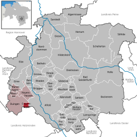
Coppengrave in the Hildesheim district
|
||
Coppengrave is a district of the borough Duingen in Hildesheim in Lower Saxony .
geography
Coppengrave is located southwest of Hildesheim between the Hils mountain ranges in the west, Duinger Berg in the east and Reuberg in the southeast. In the south, the place borders on the community-free area Grünenplan .
history
Surname
Coppengrave's old names are 1400 Kobbengraff , 1414 Kobbengraf , 1426 Cobbengraff , 1462 Coppengraven , 1471 Kobbengraff , 1478 Cobbengraven and 1499 Kobbengraue .
The place name is a compound. The evidence of the place name show forms such as "-graff, -graf, -graven" in the basic word. These have nothing to do with the nobility title “Graf”, because the forms with “-a-” apply above all in High German, but not in Low German , which must be used first and foremost for the place name. It is Middle Low German, Low German "grave" and means "dig". The location of the village in the Hille valley confirms this connection. In the first part there is - as in Coppenbrügge - an old Germanic name for “mountain, mountain peak”, ancient Germanic “kuban-, koban-”, Middle High German “kuppe” for “top, summit”, early New High German “koppe” for “mountain top, tree top ". “Head” also means “the top of a mountain”; at the end of the day, “Kuppe” also belongs here, also the “Schneekoppe”. Coppenbrügge should therefore be understood as “mountain bridge, bridge on the mountain” and “Coppengrave” as “hill moat, mountain ditch”.
Middle Ages and Modern Times
Along with Bengerode, the place was one of the places in the region where earthenware was made in the Middle Ages .
From 1974 to 1981 the place belonged to the district of Alfeld (Leine) . On November 1, 2016, the member communities of the Duingen integrated community , including Coppengrave, merged to form the new Duingen district.
politics
City council and mayor
Coppengrave is represented at the municipal level by the Duingen municipal council.
coat of arms
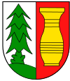
| Blazon : “Shield divided . The right half of the shield showsagreen spruce standingon a green hill on a silver background. The left half of the shield showsa golden long vase on a red background. " | |
| Foundation of the coat of arms: The choice of colors and symbols was based on the history of the village. The origin of the village can certainly be traced back to the 13th century. Since that time, wood (the village is located in the wooded valley between Hils and Duinger Berg) and clay have formed the basis of life for the village, although this landscape is still called “in the Pottlanne” to this day. The location in the forest and the livelihood “wood” are represented by the green spruce on a green hill. The livelihood of clay is represented by the red shield color. The golden long vase shows the processing of the clay. The products created in ancient times and now create the community's prosperity. |
Economy and Infrastructure
Coppengrave is connected to the road network via the state road L 462 with federal highways 3 and 240 to the west and east of the town . From 1896 to 1967 the place had its own rail connection on the disused Voldagsen-Duingen-Delligsen railway line.
Culture and sights
church
The community of the ev.-luth. Franziskuskirche belongs to the parish of Hildesheimer Land-Alfeld.
societies
- TSV Coppengrave e. V. (football, tennis, table tennis, aerobics / gymnastics / gymnastics, everyone, dancing, swimming)
- Schützenverein Coppengrave e. V.
Web links
Individual evidence
- ^ Municipalities in Germany by area and population. (XLS; 4.4 MB) → See under: No. 1773 . In: Destatis website. Federal Statistical Office, December 31, 2015, accessed on June 28, 2019 .
- ↑ Population of the Leinebergland - Coppengrave community. (PDF; 4 KB) In: www.vennekohl.de. November 30, 2016. Retrieved September 18, 2017 .
- ^ Jürgen Udolph (research): The "place name researcher". In: website NDR 1 Lower Saxony . Archived from the original on December 2, 2016 ; accessed on August 2, 2019 .
- ↑ Hans-Georg Stephan , Jan Baart: Coppengrave - Studies on pottery from the 13th to 19th centuries in Northwest Germany , 1981, p. 91.
- ↑ Lower Saxony State Chancellery (Ed.): Law on the unification of the communities of Banteln, Betheln, Brüggen, Despetal, Rheden and the city of Gronau (Leine) as well as on the new formation of the Duingen area and the Leinebergland community, Hildesheim district . Lower Saxony Law and Ordinance Gazette (Nds. GVBl.). No. 22/2015 . Hanover December 15, 2015, p. 399-400 ( digitized [PDF; 278 kB ; accessed on June 29, 2019] pp. 17–18).
- ↑ The coat of arms of Coppengrave. In: Website of the joint municipality Duingen. Retrieved September 18, 2017 .


