Hoyershausen
|
Hoyershausen
Patch Duingen
|
||
|---|---|---|
| Coordinates: 52 ° 1 ′ 6 ″ N , 9 ° 45 ′ 12 ″ E | ||
| Height : | 139 m above sea level NHN | |
| Area : | 15.3 km² | |
| Residents : | 439 (December 31, 2015) | |
| Population density : | 29 inhabitants / km² | |
| Incorporation : | November 1, 2016 | |
| Postal code : | 31089 | |
| Primaries : | 05181, 05185 | |
|
Location of Hoyershausen in Lower Saxony |
||
|
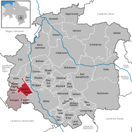
Hoyershausen in the Hildesheim district
|
||
Hoyershausen is a district of the borough Duingen in Lower Saxony Hildesheim .
geography
Hoyershausen is located southwest of Hildesheim in the Leinebergland . It is located in the valley between the Duinger Berg mountain ranges in the west and Külf in the east.
Lübbrechtsen and Rott also belong to Hoyershausen .
history
The community was first mentioned in 1338 as Haddeshusen .
During the Cold War from 1985 to 1993, a NATO ammunition and fuel depot (Forward Storage Site) of the 1st British Corps from Bielefeld was located southwest of the village in the Duinger Forest.
On November 1, 2016, the member communities of the Duingen joint community , including Hoyershausen, merged to form the new Duingen district.
Place names
Old names of the place are around 1413 Heyershusen , 1448 Heyershausen and around 1564 Heigershausen .
The late tradition makes the interpretation difficult; the name seems to have a parallel in the place name Haieshausen , e.g. B. 1276 (A. 18th century) de Heiershusen , later Hoyershusen , Hoygershusen , Heygershusen .
Therefore, a personal name Hager , Hoger can be assumed, which is best attested in Old Saxon. The first part of the personal name is to put in Old Saxon hō (h), hō (h) 'high', which is also hoge in Middle Low German , which probably influenced the double-g-spelling of the first document. Intervowel -g- falls out and leaves a diphthong -ai-, -ei-, which also appears to be -oi-, -eu- rounded. So about "settlement of a Hoger, Hoier" later rounded to Heier.
Incorporations
On March 1, 1974, for the regional reform in Lower Saxony , the communities Lübbrechtsen and Rott were incorporated.
politics
City council and mayor
Hoyershausen is represented at the municipal level by the Duingen municipal council.
coat of arms
The municipality was awarded the municipal coat of arms on February 12, 1938 by the President of the Province of Hanover . The district administrator from Alfeld presented it on June 23 of the same year.
| Blazon : "On a red shield a silver cross stone on a green hill ." | |
| Reasons for the coat of arms: Since the historical traditions of the village of Hoyershausen offered no connection options for the design of a coat of arms, a cross stone was chosen as the symbol. This monument of medieval law - rediscovered in 1935 at the von Dietsch mill and erected under a pear tree in the mill garden - was dignified in a green area in 1935 on the village square. |
Coat of arms of the incorporated localities
Culture and sights
- 1752 the nave was Maria - Lambert 's Church attached to the older tower
- In 1934 the volunteer fire brigade was founded
Economy and Infrastructure
traffic
To reach Hoyershausen, leave Bundesstraße 3 in Godenau and turn onto Kreisstraße 407 in the direction of Brunkensen. After approx. 1.5 km, turn onto Kreisstraße 409 in the direction of Deinsen . After approx. 2.5 km you will reach Hoyershausen.
Web links
Individual evidence
- ↑ a b municipalities in Germany by area, population and postcode. (XLS; 4.4 MB) → See under: No. 1775 . In: Destatis website. Federal Statistical Office, December 31, 2015, accessed on September 18, 2019 .
- ↑ Lower Saxony State Chancellery (Ed.): Law on the unification of the communities of Banteln, Betheln, Brüggen, Despetal, Rheden and the city of Gronau (Leine) as well as on the new formation of the Duingen area and the Leinebergland community, Hildesheim district . Lower Saxony Law and Ordinance Gazette (Nds. GVBl.). No. 22/2015 . Hanover December 15, 2015, p. 399-400 ( Digitalisat ( Memento of 13 May 2019 Internet Archive ) [PDF; 278 kB ; accessed on June 29, 2019] pp. 17–18).
- ^ Jürgen Udolph (research): The "place name researcher". In: website NDR 1 Lower Saxony . Archived from the original on November 27, 2015 ; accessed on September 18, 2019 .
- ^ Federal Statistical Office (ed.): Historical municipality directory for the Federal Republic of Germany. Name, border and key number changes in municipalities, counties and administrative districts from May 27, 1970 to December 31, 1982 . W. Kohlhammer, Stuttgart / Mainz 1983, ISBN 3-17-003263-1 , p. 204 .
- ^ A b Wilhelm Barner : Coat of arms and seal of the Alfeld district . Rebinding. Lax GmbH & Co. KG, Hildesheim 1998 ( digitized version of the text part of the first edition from 1940 [PDF; 10.0 MB ; accessed on June 10, 2019]).


