Külf
| Külf | |
|---|---|
|
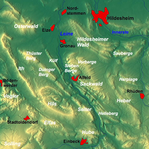
Overview map: The Külf a little above the center of the picture |
|
| Highest peak | unnamed hill ( 260 m above sea level ) |
| location | Hildesheim district , Lower Saxony Germany |
| Lower Saxony highlands | Leinebergland |
| Coordinates | 52 ° 2 ′ 0 ″ N , 9 ° 45 ′ 0 ″ E |
| rock | Limestone , marl , sandstone |
| Age of the rock | Lower shell limestone , red sandstone |
The Külf is one to 260 m above sea level. NN high ridge of the Leinebergland in the Hildesheim district in Lower Saxony ( Germany ).
Geographical location
With its seven main elevations, the Külf extends for about 9 km in the triangle of the villages of Gronau , Alfeld and Duingen . It lies between Eime and Banteln in the north, Dehnsen in the east, Limmer in the southeast, Brunkensen in the south and Hoyershausen , Lübbrechtsen and Deinsen in the west. The Thüster Berg extends west of the Külfs , the Duinger Berg southwest and the Seven Mountains to the east . The B 3 runs through the Leine valley east of the Külf in the Gronau-Alfeld section .
geology
Geologically, the Külf is part of the Alfelder Saddle, which also includes the Rettberg and Hackeberg, which are adjacent to the south (extending to the north of Freden ). The rocks consist of limestones of the Muschelkalk , hard trochitic limestone ( Upper Muschelkalk ) and "Wellenkalk" ( Lower Muschelkalk ).
Surname
The reference to the ridge can be found in almost all neighboring villages, once by the street names "Am Külf" (in Dehnsen), "Külftalstraße" (in Hoyershausen) and similar, as well as by the names in local businesses ("Külf-Apotheke", "Külf-Backerei", both in Eime).
Cölleturm
In the north of the Külfs has stood at 234 m above sea level since around 1835 . NN the lookout tower Cölleturm .
Hiking in the Külf
There are various hiking trails in the Külf , which can be mastered differently depending on the time of year due to the timber industry. In contrast to the hiking trails in the better-known ridges and mountains such as Sieben Berge , Solling and Hils , those of the Külf are less frequented. The ridge path itself is very narrow in many places and has steep slopes. It runs for around 10 km from north to south. On the eastern side you can look over the Leine valley to the Seven Mountains, to the west you can see the villages of Hoyershausen, Lübbrechtsen and Deinsen. On the northern side there are parking spaces for hikers at the entrance to Deinsen. A longer way through the Feldmark results from the slow ascent from Banteln.
literature
- Federal Institute for Regional Studies and Spatial Research: Geographical regional survey 1: 200000. Natural division of Germany. The natural space units on sheet 86 Hanover. Bad Godesberg 1960.
- Federal Institute for Regional Studies and Spatial Research: Geographical regional survey 1: 200000. Natural division of Germany. The natural space units on sheet 99 Göttingen. Bad Godesberg 1963.
