Hube (mountain range)
| Hube | ||
|---|---|---|
|
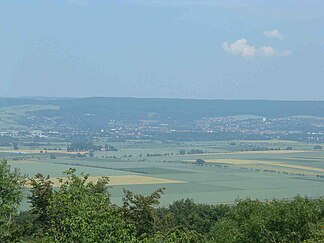
View from Grubenhagen Castle over the Ilme valley with Einbeck to the Hube |
||
| Highest peak | Fuchshöhlenberg ( 346.2 m above sea level ) | |
| location | at Einbeck ; District Northeim , Lower Saxony ( Germany ) | |
| Part of the main unit |
Southwestern Harz foreland in the Weser-Leine-Bergland |
|
| Classification according to | Handbook of the natural spatial structure of Germany | |
|
|
||
| Coordinates | 51 ° 51 ' N , 9 ° 53' E | |
The Hube near Einbeck in the district of Northeim in Lower Saxony is one to 346.2 m above sea level. NHN high ridge in the Leinebergland .
geography
location
The Hube located immediately northeast and east of the center of Einbeck and west to southwest of the hamlet Einbecker Kreiensen and northwest to the west of the line - and north of Ilme tals. Your mountain range is about 8.5 x 5.5 km.
Natural allocation
The ridge forms the natural area of Hube (376.01) in the natural spatial main unit group Weser-Leine-Bergland (No. 37), in the main unit southwest Harz foreland (376) and in the subunit Rittegau (376.0; also known as Rittigau ). Its landscape slopes down to the northeast, east and south into the Greener Leineaue (376.03) natural area . Viewed in a counterclockwise direction, it leads north into the natural area Thüster and Duinger Berg ( Reuberg , Steinberg , Selter ) (377.13), to the north-west into the natural area Brunser plateaus (377.04) and to the west into the natural area Eschershausener Liassenke (377.03), which in of the main unit Alfelder Bergland (377) belong to the subunit Eschershausener Senke (377.0). To the west - south-west the landscape falls into the Einbeck-Markoldendorfer Basin (372.0) and to the south-west into the Leineaue (372.3), which form two sub-units of the main unit Leine-Ilme-Senke (372).
geology
In the area of the bonnet, mainly carbonate stone can be found. On the western edge there is upper and middle shell limestone , in the middle area lower shell limestone and on the eastern slope upper red sandstone .
mountains
The mountains and elevations of the Hube include foothills - sorted by height in meters (m) above sea level:
|
|
Localities
Towns around the Hube, the development of which in some places extends into the ridge, are (sorted alphabetically):
|
Buildings and sights
There is a transmission mast about 150 m northwest of the summit of the Fuchshöhlenberg . In the Middle Ages and early modern times, the Hube-Chaussee, which connected the city with northern places, ran not far there. A 200 m long piece of the paving of this road, which was laid out in the 18th century, has been preserved there on Eschenberg, consisting of 20 to 40 cm wide stone blocks made from Terebratel benches of the Lower Muschelkalks , some of which are from the local area and some of them, as by Ludwig Gottlieb Crome testifies that they came from the demolition of the Augustinian Hermit Monastery . In large parts of the Hube, the historic Einbecker Landwehr is still very well preserved. To the north of Negenborn on the castle hill are the remains of a medieval ring wall .
On the northern edge of the Greener Wald, the northern part of the Hube, above Greene lies the ruins of Greene Castle , with a view from the castle tower. Another vantage point is the Mönchelieth on the Lietberg above Holtershausen , whose history is reminiscent of a wooden cross and an information board . In the southern part of the Hube, around 570 m north of the Altendorfer Berg between Einbeck and Negenborn, there is the Kaiser Friedrich Tower (Einbeck Tower) inaugurated in 1900 .
traffic
The federal road 64 leads north past the Hube, which is criss-crossed by forest and hiking trails, and the federal road 445 runs a few kilometers to the east . In the south and west of the federal highway 3 (this route shares with the German half-timbered road ) the ridge is passed in a semicircle.
To the north, the Hube is passed by the Altenbeken – Kreiensen railway line , with a nearby train station in Kreiensen . The Hannöversche Südbahn (main line Hanover - Göttingen ) runs past the ridge to the east with nearby train stations in Kreiensen and Salzderhelden . The single-track line branches off from Salzderhelden to Einbeck Mitte. The Hanover – Würzburg high-speed line also runs along there. South from 1883 to 2003 caused at the Hube, the single-track railway line Ilmebahn over, Dassel association and Einbeck each other.
Individual evidence
- ↑ Map services of the Federal Agency for Nature Conservation ( information )
- ^ Jürgen Hövermann: Geographical land survey: The natural space units on sheet 99 Göttingen. Federal Institute for Regional Studies, Bad Godesberg 1963. → Online map (PDF; 4.1 MB)
- ↑ Jochen Lepper: The old Hube-Chaussee north of Einbeck, in: Einbecker Jahrbuch 39, 1988, pp. 179-184
- ↑ Erhard Cosack : Latenezeitliche Fundhorizonte, in: Jahrbuch des Römisch-Germanisches Zentralmuseums 54, 2007, p. 297ff
- ↑ Kaiser-Friedrich-Turm is finished, in: Einbecker Morgenpost from 21.9.2010 ( online )
literature
- Fr. Knoll: Topography of the Duchy of Braunschweig . Wollermann publisher 1897
- Federal Institute for Regional Studies and Spatial Research: Geographical regional survey 1: 200000. Natural division of Germany. The natural space units on sheet 99 Göttingen. Bad Godesberg 1963

