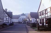
Reileifzen
Reileifzen is the name of a district of the town of Bevern in the Holzminden district in Lower Saxony .
Geographical location
The village lies between Bevern and Bodenwerder on the east bank of the Weser. It is surrounded by the mountain forests of the Solling-Vogler Nature Park . About a kilometer away in a southerly direction is the Heinsener Klippen natural forest reserve .
history
According to the municipality of Bevern, the name of the village has been known since the 12th century. According to recent research, the first documentary mention is seen in a document from 1197 in which the place name is given as "Reinleuessen". Further documents from the time around 1198 and around 1200 are only preserved as copies from the 13th century and pass on the place names as "Reinlievessen" and "Reinlevessen". A document from the year 1018 with the mention of a place "Reinlevessen", which was referred to in older literature on Reileifzen, is today related to a place near Warburg . Reileifzen has been part of the Golmbach parish and the patronage of the Amelungsborn monastery since the Middle Ages . There was also a Fronhof of the monastery in the village, in 1319 a monk is named as its head ("rector curiae in Reinlevessen"). Later - probably in 15./16. Century - Reileifzen was deserted until Duke Heinrich the Younger settled the place again. The new settlement was built near the old one. There was no longer a manorial farm, rather free farmers were settled. The place was now a street village .
With the incorporation of the surrounding villages of Bevern, Reileifzen became part of the integrated municipality of Bevern on January 1, 1973.
Village development
As part of the Solling-Vogler model village initiative , the village of Reileifzen is supported by a funding program ( LandZukunft ) from the Federal Ministry of Food and Agriculture .
Web links
- The village of Reileifzen Brief description of Reileifzen on the website of the municipality of Bevern.
- Reileifzen volunteer fire department Website of the Reileifzen local fire department.
- Our home village Reileifzen Website of the "Verkehrsverein Reileifzen 1969 eV" (homepage).
- LandZukunft in the Solling-Vogler region (PDF file).
Individual evidence
- ^ The village of Reileifzen Website of the municipality of Bevern.
- ^ The village of Reileifzen Brief description of Reileifzen on the website of the municipality of Bevern.
- ↑ Profile of the Naturwaldea Heinsener Klippen database "Natural forest reserves in Germany" of the Federal Agency for Agriculture and Food .
- ↑ a b The village chapel Reileifzen Description on the website of the Samtgemeinde Bevern, accessed on January 21, 2017.
- ↑ a b Kirstin Casemir, Uwe Ohainski: The place names of the district of Holzminden (= Jürgen Udolph [Hrsg.]: Lower Saxon Place Name Book (NOB) . Part VI). Publishing house for regional history, Bielefeld 2007, ISBN 978-3-89534-671-2 , p. 177-178 .
- ↑ a b Herhard Meyer, Christian Leiber, Andreas Lilge, Andreas Reuschel, Gerhard Streich: Historical-regional excursion map of Lower Saxony, sheet Holzminden . Scale 1: 50,000. Ed .: Gerhard Streich. Publishing house for regional history, Bielefeld 1997, ISBN 3-89534-214-9 , 5.Ländliche Siedlungen , p. 35 .
- ↑ The spots Bevern Information from the municipality of Bevern.
- ↑ LandZukunft in the Solling-Vogler region (PDF file).
Coordinates: 51 ° 54 ' N , 9 ° 28' E
