Harderode
|
Harderode
Coppenbrügge spots
|
||
|---|---|---|
| Coordinates: 52 ° 2 ′ 41 ″ N , 9 ° 32 ′ 28 ″ E | ||
| Height : | 169 m above sea level NHN | |
| Area : | 7.85 km² | |
| Residents : | 380 (2006) | |
| Population density : | 48 inhabitants / km² | |
| Incorporation : | 1st January 1973 | |
| Postal code : | 31863 | |
| Area code : | 05159 | |
|
Location of Harderode in Lower Saxony |
||
|
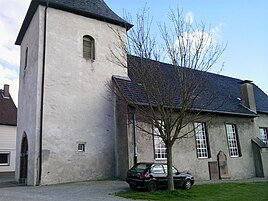
Harderode Church
|
||
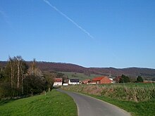
Harderode is a district of the borough Coppenbrügge in Lower Saxony district Hameln-Pyrmont .
location

The place is in the Ilsetal on the southwest slope of the Ith between Bisperode and Halle (Weserbergland) . The L 588 runs through the village . The 2,715 ha large nature reserve Ith is located one kilometer east.
history
Harderode was first mentioned as Hiris Witherothe in 990/91 . In 1330 it was called Herderode , 1385 as Hersederode and 1510 as Harderode . From 1940 to 1958 a business school for women was operated there, which later returned to the Trillke-Gut rural school in Hildesheim.
Incorporations
Originally part of the Holzminden district, Harderode came to the Coppenbrügge district in the Hameln-Pyrmont district on January 1, 1973.
Population development
|
|
¹ only men indicated
politics
Local councilor and local mayor
The local council of the village of Bisperode represents the Coppenbrügger districts of Behrensen, Bessingen , Bisperode, Diedersen and Harderode at the municipal level .
Culture and sights
Buildings
- Village church
Personalities
Sons and daughters of the place
- Friedrich Greve (1892–1956), politician ( SPD )
Web links
Individual evidence
- ↑ a b Federal Statistical Office (ed.): Official municipality register for the Federal Republic of Germany . Final results according to the September 13, 1950 census. Volume 33 . W. Kohlhammer Verlag, Stuttgart / Cologne August 1952, p. 36 , col. 2 ( digital version [PDF; 26.4 MB ; accessed on November 11, 2019] Landkreis Holzminden, p. 45).
- ↑ Ortrud Wörner-Heil: Women's schools in the country - Reifensteiner Verband (1897–1997) (= series of publications of the archive of the German women's movement . Volume 11 ). Archives of the women's movement, 1997.
- ^ Federal Statistical Office (ed.): Historical municipality directory for the Federal Republic of Germany. Name, border and key number changes in municipalities, counties and administrative districts from May 27, 1970 to December 31, 1982 . W. Kohlhammer, Stuttgart / Mainz 1983, ISBN 3-17-003263-1 , p. 195 .
- ^ Ulrich Schubert: Community directory Germany 1900 - Holzminden district. Information from December 1, 1910. In: gemeindeververzeichnis.de. February 3, 2019, accessed November 13, 2019 .
- ↑ a b c Michael Rademacher: German administrative history from the unification of the empire in 1871 to the reunification in 1990. Landkreis Holzminden ( see under: No. 30 ). (Online material for the dissertation, Osnabrück 2006).


