Dörpe (Coppenbrugge)
|
Dörpe
Coppenbrügge spots
|
||
|---|---|---|
| Coordinates: 52 ° 8 ′ 9 ″ N , 9 ° 34 ′ 1 ″ E | ||
| Height : | 195 m above sea level NHN | |
| Area : | 2.49 km² | |
| Residents : | 754 (Sep 13, 1950) | |
| Population density : | 303 inhabitants / km² | |
| Incorporation : | 1st January 1973 | |
| Postal code : | 31863 | |
| Area code : | 05156 | |
|
Location of Dörpe in Lower Saxony |
||
|
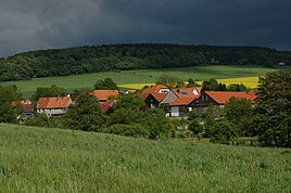
Dörpe, in the background the Osterwald
|
||
Dörpe is a village in the north-eastern Weserbergland, part of the Coppenbrügge district in the Hameln-Pyrmont district in Lower Saxony .
location
It is located on the pass road (Landesstraße 422) from Eldagsen to Coppenbrügge in the valley of the Gelbbach brook, which separates the south-western slopes of the Nesselberg and Osterwald .
history
The first mention of the name Dörpe can be found with the mention of a witness Bartholomeus van der Dörpe in 1393 in the Hamelin document book. It is assumed that this is a resident of the village. The exact origin of the body is not known. The so-called Meierhöfe and, because of the local clay deposits, also pottery rooms existed early on as hereditary farms . From the 16th century, coal mining developed both in the nearby Osterwald and in the Gelbbachtal above Dbodes. It was an important source of income for the local residents. After the abandonment of coal mining in the middle of the 20th century, the Wilhelm Schmull quarry developed from it , which gave many residents a living, especially in the difficult years of the post-war period .
Incorporations
On January 1, 1973 Dörpe was incorporated into the spots Coppenbrügge.
Population development
| year | 1910 | 1925 | 1933 | 1939 | 1950 |
|---|---|---|---|---|---|
| Residents | 446 | 377 | 334 | 355 | 754 |
| source |
politics
Local councilor and local mayor
The local council of the town of Coppenbrügge represents the Coppenbrügge districts Coppenbrügge, Dörpe and Marienau at the municipal level .
Economy and Infrastructure

Today the quarry no longer exists, in the former stone saw in the village center there is now a horticultural business. In Dörpe there are still two farms, one of which has a farm shop and a forestry wage company. There are also some handicrafts and craft businesses. Furthermore, there are many activities and festivals in Dörpe such as an artist's festival every year in early summer, barn festivals, soap box races and fire brigade competitions, as well as a fire brigade festival with a fair and an official festival and fun parade every five years . Due to its own employment opportunities and cultural fields of activity, Dörpe is not just a sleeping village for commuters to nearby large cities.
Nature and tourism
There are several hiking trails in the immediate vicinity of the village, the most of which is the restored historic Dbody miners' path. It is reminiscent of the mining industry on the slopes of Nesselberg and Osterwald and follows the work route of the Dbody to the various quarries. Dörpe is idyllically situated in a brook valley on the south-western slopes of these mountains; together with the Kleiner Deister they form a south-eastern continuation of the Großer Deister . There are horse riding opportunities in town as well as individual holiday homes. A far-reaching panoramic view is offered by the "Three Thick Beeches" on the Bergmannspfad on the edge of the Osterwald. At the edges of the path there are nature and history-related information boards, including the historical cherry tree avenue on the hillside of the Ruhbrink.
Web links
Individual evidence
- ↑ a b c Federal Statistical Office (Hrsg.): Official municipality register for the Federal Republic of Germany . Final results according to the September 13, 1950 census. Volume 33 . W. Kohlhammer Verlag, Stuttgart / Cologne August 1952, p. 29 , col. 2 ( digital version [PDF; 26.4 MB ; accessed on November 12, 2019] District Hameln-Pyrmont, p. 38).
- ^ Dorfgemeinschaft Dörpe (ed.): Dorfchronik Dörpe . 1989.
- ^ Federal Statistical Office (ed.): Historical municipality directory for the Federal Republic of Germany. Name, border and key number changes in municipalities, counties and administrative districts from May 27, 1970 to December 31, 1982 . W. Kohlhammer, Stuttgart / Mainz 1983, ISBN 3-17-003263-1 , p. 195 .
- ^ Ulrich Schubert: Community directory Germany 1900 - district Hameln. Information from December 1, 1910. In: gemeindeververzeichnis.de. February 3, 2019, accessed November 13, 2019 .
- ↑ a b c Michael Rademacher: German administrative history from the unification of the empire in 1871 to the reunification in 1990. Hameln-Pyrmont district ( see under: No. 19 ). (Online material for the dissertation, Osnabrück 2006).


