
Emmerthal
| coat of arms | Germany map | |
|---|---|---|

|
Coordinates: 52 ° 2 ' N , 9 ° 23' E |
|
| Basic data | ||
| State : | Lower Saxony | |
| County : | Hameln-Pyrmont | |
| Height : | 87 m above sea level NHN | |
| Area : | 114.62 km 2 | |
| Residents: | 9728 (Dec. 31, 2019) | |
| Population density : | 85 inhabitants per km 2 | |
| Postal code : | 31860 | |
| Primaries : | 05155, 05157 , 05286 , 05151 | |
| License plate : | HM | |
| Community key : | 03 2 52 005 | |
| LOCODE : | DE EMT | |
| Community structure: | 4 villages with 17 districts | |
| Address of the municipal administration: |
Berliner Strasse 15 31860 Emmerthal |
|
| Website : | ||
| Mayor : | Andreas Grossmann ( SPD ) | |
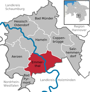
| Location of the municipality of Emmerthal in the Hameln-Pyrmont district | ||
  |
||

Emmerthal is a municipality in the Hameln-Pyrmont district in Lower Saxony . It consists of 17 formerly independent villages on both sides of the Weser in the Weserbergland Nature Park .
geography
Community structure
The municipality consists of four localities with 17 districts:
- Amelgatzen , consisting of the former communities Amelgatzen, Hämelschenburg and Welsede
- Börry , consisting of the former communities of Börry, Bessinghausen , Brockensen , Esperde , Frenke , Hajen and Latferde
- Emmerthal, consisting of the former municipalities of Emmern , Hagenohsen , Kirchohsen , Ohr and Voremberg
- Grohnde , consisting of the former town of Grohnde and the former municipality of Lüntorf
history
Prehistory and early history
Oldest evidence of human existence in the area is an estimated at 60,000 years hand-ax , which is owned by the Hamelin is the museum. A ford through the Weser made it possible to connect to an early road network . Street names and the Hellberg are reminiscent of the Hellweg .
middle Ages
Emmerthal was in the " Tilithigau ". Charlemagne is said to have founded a mission center with a church in " Ohsen " (later "Kirchohsen" and today's seat of administration in the core area of the municipality of Emmerthal), which was archdeacon of the Bishop of Minden from around 800 to 1200 . The monastery of St. Boniface had existed since around 800, but the bishop chose the easily accessible Ohsen as the seat of his archdeacon and deputy.
In the year 1004 Ohsen was mentioned for the first time . King Henry II , the saint , signed a deed in Villa Ohsen.
In the conflict between Franconia, Saxony and Welfen (" Heinrich the Lion "), the Counts of Everstein developed from their Everstein Castle , located on the Everstein between Lobach and Negenborn (west of Stadtoldendorf ), from independence and power. With their castles in Hermersen ( Hämelschenburg ), Ohsen Castle and the Ohr Manor , they shaped the Emmerthal area in the 12th and 13th centuries.
Further documented mentions of Ohsen come from the year 1259. After the end of the Duchy of Saxony , the Counts of Everstein and the noble lords of Homburg were the most powerful dynasties in southern Lower Saxony . The families' possessions overlapped in the area of the Weser . In the turmoil of time, the Homburgs stood on the side of Henry the Lion , the Counts of Everstein fought with Emperor Friedrich Barbarossa . After Heinrich's fall, the Everstein counts sought protection from the Bishop of Cologne and transferred Ohsen Castle to him . But the counts could not stop the advance of Heinrich the Lion: They had to give up Everstein Castle and moved to Ohsen. From 1408 the office of Ohsen was under the principality of Calenberg .
Modern times


The Emmerthal area has a checkered history with acts of war and the desolation of settlements.
- The Protestant Church of St. Mary of 1563 remained in the Thirty Years' War only by Anna Klenckes courage and Tilly threat of the death penalty against the looting and pillaging of the Catholic troops spared. In contrast, the Weser bridge was destroyed by Grohnde in 1633. Today there is a yaw ferry there .
- In the Seven Years' War Hämelschenburg was occupied. On July 24th and 25th, 1757, the French troops, under the command of Marshal d'Estrées, pitched their camps around Frenke, Börry and Bessinghausen, only to win the Battle of Hastenbeck the next day .
- In 1654 and 1655 the procedures against a witch and a magician were described in detail in the church book of Kirch ohsen.
When the offices of Grohnde and Ohsen later administered the area, the situation had improved. In 1810 the Ohrberg Park was laid out . In 1823 the smaller office of Ohsen was incorporated into the office of Grohnde, which in turn was incorporated into the office of Hameln in 1859 . This resulted in the Prussian district of Hameln in 1885 .
20th century
The municipality of Emmerthal was formed by the "Law for the reorganization of the municipalities in the Hameln area" on January 1, 1973 from 17 previously independent places.
Population development

|
(Population figures: 1961: on June 6th, 1970: on May 27th, always within today's limits, from 1987: on December 31st)
politics
advice
The council of the municipality of Emmerthal consists of 23 councilors. The full-time mayor Andreas Grossmann (SPD) is also entitled to vote in the council.
The last local election on September 11, 2016 resulted in the following:
mayor
The full-time mayor of the municipality of Emmerthal is Andreas Grossmann (SPD). In the last mayoral election on May 25, 2014, he was re-elected as incumbent with 56.4% of the vote. His opponent, Rudolf Welzhofer, received 43.6%. The turnout was 57.4%. Grossmann began his further term in office on November 1, 2014.
coat of arms
Description of coat of arms : Split by a rising single-tailed golden tip, inside a black mill wheel; on the right, in blue, a rising, red crowned and red-armored lion, on the left, in blue, a silver, oblique, right-hand wave bar.
The municipality colors (also flag colors) are gold and blue.
Culture and sights
Landscape and (cycling) hiking
The landscape around Emmerthal is characterized by the side valley of the Emmer and the valleys of the Weser and Ilse as well as the forests of the Bückeberg , Scharfenberg, Hellberg, Ruhberg, Baßberg and Grohnder Forst. Emmerthal is located on the Weserradweg , the Weserberglandwanderweg and the Weser Renaissance road .
Buildings


- Hämelschenburg Castle as the main work of the Weser Renaissance and one of the last completely preserved Renaissance complexes in Germany
- Manor ear as in the Middle Ages resulting manor and since 1307 owned by the family von Hake
- The St. Mary's Church on Castle Hämelschenburg, one of the oldest Protestant church buildings in northern Germany
- The former site of the Reichserntedankfest, which took place from 1933 to 1937
Ohrbergpark
In the Ohrbergpark , which was created in 1810, there are azaleas and rhododendron bushes as well as exotic trees. In the southern part there is an alternation of open spaces and woody plantings, in the northern part the park turns into a light forest with sunken paths and stairs.
Museum of Agricultural Engineering and Agricultural Labor
The museum for agricultural technology and agricultural work in Börry gives an insight into the rural life of different epochs. The change from manual to mechanized agriculture is discussed. Old agricultural machines are exhibited in an outdoor area.
Culture
The community runs the Emmerthal cultural program “Time for Culture in Emmerthal”. There is an extensive cultural life, including through museums.
music
There are various choral societies, choirs and orchestras.
Sport and social
There are sports clubs and tennis courts, indoor swimming pools and sports halls (in Kirchohsen), kindergartens and children's play areas, old people's and nursing homes and facilities for assisted living.
Economy and Infrastructure
Emmerthal in the city triangle Hameln - Bad Pyrmont - Bodenwerder has favorable conditions for tourism and settlement projects of all kinds. There is building land from municipal property as well as developed land for business settlements.
traffic
The community is conveniently connected between the areas Hannover-Hildesheim in the east and Ostwestfalen-Lippe in the west by the federal highway 83 ; the station Emmerthal in the northwest of the municipality lies on the railway line Hannover-Altenbeken crosses here the Weser and the S-Bahn line S5 Paderborn - Hameln - Hannover Hbf - Hannover Airport is served. In addition, the former Vorwohle-Emmerthaler Railway branches off here . Buses also run regularly. In Grohnde there is a roller ferry across the Weser.
Companies
The metal and wood processing industry, apparatus engineering, chemical industry and pharmaceutical production are located here. In addition to the Grohnde nuclear power plant, there is a wind power plant in Börry and the solar research institute in Ohr. There are also some medium-sized companies.
Public facilities
There is a swimming pool in Kirchohsen that was renovated before 2002.
education
There are elementary schools in Kirchohsen, Amelgatzen and in Börry as an educational center since January 2015 in connection with the day care center, in Kirchohsen there is a secondary and secondary school, the Johann-Comenius-Schule. The primary school in Grohnde was closed in summer 2010.
Research institutions
On November 18, 1993, the new building of the Institute for Solar Energy Research GmbH Hameln / Emmerthal (ISFH) was opened in Ohr . The decision to found the Institute for Solar Energy Research was taken in 1985 by the state government in Hanover on the initiative of Hellmut Glubrecht; In 1987 the institute started its work in Hanover. In 1993 the photovoltaics and solar thermal departments moved into the new building near Hameln; the then third department of photocatalysis remained close to the university at the Hanover location. The Hanover location was only given up after a building extension was completed in 2000. The Institute for Solar Energy Research is an affiliate of the University of Hanover ; it currently employs around 160 people. The managing director of the ISFH, Rolf Brendel, is also a professor in the Faculty of Mathematics and Physics and heads the solar energy department there. In 2008, an approximately 850 m² extension (technology hall) was completed in front of the main building. The technology hall houses a large number of large devices for industrial solar cell production and collector development.
Sons and daughters of the church
- Konrad von Schäffer (1770–1838), Minister of War of the Grand Duchy of Baden
- Paul Jacobshagen (1889–1968), ev. Pastor, local politician of the NSDAP and member of the German Christians
- Klaus Kuhrmeyer (* 1941) parish pastor 1978–2007
- Hans-Otto Budde (* 1948), German general
People related to the community
- Fritz Saacke (1926–2017), Mayor of Emmerthal, District Administrator , Member of Parliament
literature
- Hans-Cord Sarnighausen: Local lawyers from 1635 to 1859 in Grohnde / Weser , Museum Association Hameln Yearbook 2008, pp. 34–57 with illustrations and 49 sources.
- Kirchohsen church book , 1654 and 1655, longer explanations of the practiced Inquisition .
Web links
- Website of the unified municipality Emmerthal
- Culture website of the municipality of Emmerthal "Time for culture in Emmerthal"
Individual evidence
- ↑ State Office for Statistics Lower Saxony, LSN-Online regional database, Table 12411: Update of the population, as of December 31, 2019 ( help ).
- ↑ Main statutes of the municipality of Emmerthal - local councils , accessed on November 12, 2014
- ↑ A source from 1765 mentions a window that shows Charlemagne and bears the signature: "King Carolus Magnus Fundator Ecelesiae in Osen - MCLX", d. H. Charlemagne, founder of the church in Ohsen.
- ^ A Grohnde castle is not mentioned until 1421
- ↑ Names and descriptions can be found on Uwe Copei's website under the rubric Wüstungen: [1]
- ↑ a b Federal Statistical Office (ed.): Historical municipality register for the Federal Republic of Germany. Name, border and key number changes in municipalities, counties and administrative districts from May 27, 1970 to December 31, 1982 . W. Kohlhammer GmbH, Stuttgart and Mainz 1983, ISBN 3-17-003263-1 , p. 194 .
- ↑ Regional statistics database , State Office for Statistics and Communication Technology Lower Saxony LSKN-Online
- ↑ Individual results of the direct elections on May 25, 2014 in Lower Saxony ( Memento of the original from March 3, 2016 in the Internet Archive ) Info: The archive link was inserted automatically and has not yet been checked. Please check the original and archive link according to the instructions and then remove this notice. , accessed November 8, 2014
- ↑ http://www.johann-comenius-schule.de/
- ^ Karl-Friedrich Oppermann : JACOBSHAGEN, Paul Friedrich Hermann. In: Dirk Böttcher , Klaus Mlynek, Waldemar R. Röhrbein, Hugo Thielen : Hannoversches Biographisches Lexikon . From the beginning to the present. Schlütersche, Hannover 2002, ISBN 3-87706-706-9 , p. 185; online through google books