
Averhoy
|
Averhoy
City of Neustadt am Rübenberge
|
||
|---|---|---|
 |
||
| Height : | 34 m above sea level NHN | |
| Area : | 2.68 km² | |
| Residents : | 80 (March 31, 2020) | |
| Population density : | 30 inhabitants / km² | |
| Incorporation : | March 1, 1974 | |
| Postal code : | 31535 | |
| Area code : | 05032 | |
Location of Averhoy in Lower Saxony |
||
_IMG_7845.jpg) Town view
|
||

Averhoy is a district of the city of Neustadt am Rübenberge in the Hanover region of Lower Saxony .
geography
The village is located south of the Leine on state road 193 .
history
The place was first mentioned as Overoje or Overhoye in 1217. It later belonged to the Basse bailiwick .
Incorporations
In the course of the regional reform in Lower Saxony , the municipality of Averhoy lost its political independence on March 1, 1974 and became a district of Neustadt am Rübenberge.
Population development
| year | Residents | source |
|---|---|---|
| 1910 | 84 | |
| 1925 | 77 | |
| 1933 | 67 | |
| 1939 | 66 | |
| 1950 | 169 | |
| 1956 | 113 | |
| 1973 | 75 | |
| 2016 | 85 | |
| 2020 | 80 |

|
politics
Local council
The joint local council of Averhoy, Basse, Metel , Otternhagen and Scharrel consists of two council women and nine councilors. There are also 19 advisory members in the local council.
Distribution of seats:
(Status: local election September 11, 2016)
Local mayor
The local mayor is Wilfried Schneider (CDU). His deputy is Uwe Münkel (UWG NRÜ).
Culture and sights
Architectural monuments
Photo gallery
 court
court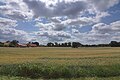 Look at Averhoy
 View of the nature reserve
_IMG_7836.jpg)
_IMG_7840.jpg)
_IMG_7837.jpg)
Web links
Individual evidence
- ↑ a b Our localities introduce themselves - Otternhagen / Averhoy. In: Website of the city of Neustadt am Rübenberge. 2016, accessed November 15, 2017 .
- ↑ a b residents per location according to the population register. (PDF; 86 kB) In: Website City Neustadt am Rübenberge. March 31, 2020, accessed May 28, 2020 .
- ↑ Hans Ehlich: farmers citizens burning villages. 30 historical pictures from the Neustadt a. Rbge (= Calenberger Blätter . No. 4 ). Theo Oppermann Verlag, Wunstorf 1963, p. 130 .
- ↑ Edfried Bühler u. a .: Home chronicle of the Neustadt am Rübenberge district . Cologne 1974, p. 72 .
- ^ Federal Statistical Office (ed.): Historical municipality directory for the Federal Republic of Germany. Name, border and key number changes in municipalities, counties and administrative districts from May 27, 1970 to December 31, 1982 . W. Kohlhammer, Stuttgart / Mainz 1983, ISBN 3-17-003263-1 , p. 198 .
- ↑ Ulrich Schubert: Municipal directory Germany 1900 - District Neustadt am Rübenberge. Information from December 1, 1910. In: gemeindeververzeichnis.de. January 5, 2020, accessed May 28, 2020 .
- ^ A b c Michael Rademacher: German administrative history from the unification of the empire in 1871 to the reunification in 1990. Neustadt am Rübenberge district ( see under: No. 2 ). (Online material for the dissertation, Osnabrück 2006).
- ↑ a b Statistisches Bundesamt Wiesbaden (ed.): Official municipality register for the Federal Republic of Germany - 1957 edition (population and territorial status September 25, 1956, for Saarland December 31, 1956) . W. Kohlhammer, Stuttgart 1958, p. 160 ( digitized version ).
- ↑ Lower Saxony State Administration Office (ed.): Municipal directory for Lower Saxony . Municipalities and municipality-free areas. Self-published, Hanover January 1, 1973, p. 24 , district Neustadt am Rübenberge ( digitized version ( memento from August 7, 2019 in the Internet Archive ) [PDF; 21.3 MB ; accessed on May 28, 2020]).
- ↑ a b Local council of the village of Otternhagen / Averhoy. In: Council information system of the city of Neustadt am Rübenberge. Retrieved November 10, 2017 .
- ↑ a b elected officials of the city. In: Council information system of the city of Neustadt am Rübenberge. Retrieved November 10, 2017 .

Bevensen (with Büren and loader wood ) |
Bordenau |
Eilvese |
Helstorf (with Esperke / Warmeloh , Luttmersen and Vesbeck ) |
Mandelsloh (with Amedorf , Brase / Dinstorf , Evensen , Lutter , Niedernstöcken , Stöckendrebber and Welze ) |
Mardorf |
Mariensee (with Empede / Himmelreich and Wulfelade ) |
Mühlenfelder Land (with Borstel , Dudensen , Hagen and Nöpke ) |
Neustadt |
Otternhagen (with Averhoy , Basse , Metel and Scharrel ) |
Poggenhagen |
Snow |
Suttorf