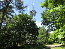
Kellenberg
The Kellenberg is an island-like, hilly mountain range up to 77 m high in the district of Diepholz in central Lower Saxony ( Germany ).
geography
The densely wooded hilly landscape of the Kellenberg, which measures around 8 km in north-south direction and around 2 to 4 km in west-east direction, is located in the southern part of the north German lowlands, around 50 km south-south-west of Bremen and around 50 km north-east from Osnabrück .
In terms of its natural surroundings, the Kellenberg lies between the Diepholzer Moorniederung in the north ( Großes Moor , Wietingsmoor ) and the foreland of the Wiehengebirge and the upstream Stemweder Berg, which gradually rises to the south . Further moors lie in the east ( Neustädter Moor ) and south ( Rehdener Geestmoor ). Large valleys of the north-facing rivers flank the Kellenberg on both sides; east of the Wagenfelder Aue and the Große Aue , to the west the valley of the Hunte with the Dümmer .
The village of Kellenberg on the southern edge belongs to the municipality of Hemsloh of the combined municipality of Rehden .
Geology and landscape
The Kellenberg, which is mainly made up of sand, is part of an ice age terminal moraine series from the early glaciation of the Saale Ice Age , the so-called Drenthe I stage. To this as Rehburger phase designated ice stage , which can be dated to around 230,000 years before present, also belonging Lingen Heights that Ankum Heights , which the Kellenberg west neighboring Damme Hills and Brelinger mountain (but not the rehburg hills at Steinhude ). In its gently rolling hilly landscape there are lakes and ponds in former sand pits , which enrich the wooded landscape, which is characterized by pine stands of the Erdmannshausen state forest.
Transport links
The southwest edge of the Kellenberg is followed by a section of the B 239 , which connects Rehden in the northwest with Wagenfeld in the southeast. The ridge is crossed in the middle by the B 214 , which leads from Rehden in the west to Barver in the east.
Surveys
In addition to the highest mountain top of the same name (77 m above sea level ; with transmitter ), the Kellenberg has at least four other unnamed elevations between 52 and 72 m high.
Waters
Because of the mostly permeable subsoil, there are only insignificant flowing waters in the ridge itself . Of standing water , however, there are several small lakes and ponds in the middle part of the hills. Further outside, the hilly landscape in the west and northwest pass the Hunte (western tributary of the Weser ) and in the east the Wagenfelder Aue (southern tributary of the Hunte).
Localities
The villages in and near the Kellenberg include:
Coordinates: 52 ° 36 ' N , 8 ° 31' E
