Rott (Extertal)
|
Red
Extertal municipality
Coordinates: 52 ° 7 ′ 59 ″ N , 9 ° 7 ′ 32 ″ E
|
|
|---|---|
| Height : | 186 m |
| Area : | 7.33 km² |
| Residents : | 337 (December 31, 2016) |
| Population density : | 46 inhabitants / km² |
| Incorporation : | 1st January 1969 |
|
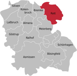
Location of Rott in Extertal
|
|
Rott is a scattered settlement in Ostwestfalen-Lippe with around 337 inhabitants (as of December 31, 2016). It is a district of the municipality Extertal in the Lippe district in North Rhine-Westphalia . The Extertal holiday park with around 180 holiday homes is also part of the Rott district .
Location and description
The place is in the northwest of the 1969 by the Lemgo law newly founded municipality Extertal in the southern Weserbergland orographically left, d. H. south of the Weser and was until then an independent municipality. It lies at an altitude between about 200–240 meters above sea level . The course of the Exter is located to the west of the village at the neighboring Bremke district .
Bösingfeld , the main town of the municipality, is located approx. 7 kilometers south, Rinteln 7 kilometers north, Hameln 16 kilometers east and Lemgo 19 kilometers southwest.
history
Rott is first mentioned in writing in 1465 as Rode . The place, which had fallen desert at times , was then repopulated before 1507.
On January 1, 1969, the previously independent municipality of Rott was incorporated into the new municipality of Extertal.
Infrastructure
The Extertalstraße , the state road NRW 758, runs to the west of the town near Bremke, which turns into the state road L 435 (Lower Saxony) at the state border between North Rhine-Westphalia and Lower Saxony between Silixen and Krankenhagen and creates a connection between the towns of Barntrup and Rinteln through the Extertal . The Extertalbahn , which is now only used for tourism, runs almost parallel to the road . At Bremke there was a train station on this railway line.
Even if the village of Rott is still rural, agriculture and forestry hardly play a significant role today . But tourism has now taken on a certain economic role. There is a holiday park with around 100 holiday homes immediately north of the original village.
There are no sights in the village. A few kilometers south on the "Rintelschen Hagen" are the remains of the ramparts of the Uffoburg , an early medieval castle.
Web links
- Official website of the municipality of Extertal
- Rott (Extertal) in the Westphalia Culture Atlas
Individual evidence
- ↑ extertal.de
- ↑ Tim-online.de
- ↑ Birgit Meineke : The place names of the Lippe district. (= Westphalian Place Name Book Volume 2). Publishing house for regional history, Bielefeld 2010, ISBN 978-3-89534-842-6 , p. 413. ( PDF )
- ↑ Willy Gerking: The desertions of the Lippe district: a historical-archaeological and geographical study of the late medieval desert events in Lippe. Aschendorff, 1995, p. 51; 77, ISBN 9783402050354
- ↑ Martin Bünermann: The communities of the first reorganization program in North Rhine-Westphalia . Deutscher Gemeindeverlag, Cologne 1970, p. 67 .
- ↑ Rinteln.de

