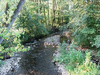
Exter (Weser)
| External | ||
|
The exter at Almena |
||
| Data | ||
| Water code | EN : 458 | |
| location | Lippe , Schaumburg ; North Rhine-Westphalia , Lower Saxony ; Germany | |
| River system | Weser | |
| Drain over | Weser → North Sea | |
| source | Southwest of Alverdissen 52 ° 1 ′ 44 ″ N , 9 ° 6 ′ 22 ″ E |
|
| Source height | approx. 279 m above sea level NN | |
| muzzle | In Rinteln in the Weser Coordinates: 52 ° 11 '25 " N , 9 ° 5' 6" E 52 ° 11 '25 " N , 9 ° 5' 6" E |
|
| Mouth height | approx. 52 m above sea level NN | |
| Height difference | approx. 227 m | |
| Bottom slope | approx. 8.7 ‰ | |
| length | 26.1 km | |
| Catchment area | 108.718 km² | |
| Discharge at the Uchtdorf A Eo gauge : 99.6 km². Location: 4.6 km above the mouth |
NNQ (09/29/1964) MNQ 1961/2014 MQ 1961/2014 Mq 1961/2014 MHQ 1961/2014 HHQ (08/21/2007) |
90 l / s 274 l / s 1.4 m³ / s 14.1 l / (s km²) 25.3 m³ / s 42.6 m³ / s |
| Discharge at the mouth of A Eo : 108.72 km² |
MQ Mq |
1.51 m³ / s 13.9 l / (s km²) |
The Exter is a 26.1 km long orographic left or southern tributary of the Weser in the North Rhine-Westphalian district of Lippe and in the district of Schaumburg in Lower Saxony ( Germany ).
It gave its name to the municipality of Extertal , newly founded in 1969 , whose area corresponds to a large part of its 108.7 km² catchment area.
course
The Exter rises in the eastern part of the Lippe district in the Teutoburg Forest / Eggegebirge nature park . Its source is in the municipality of Barntrup about 1 km west-southwest of the center of the northern district of Alverdissen in an agricultural area at 279 m above sea level. NN .
Directly below its origin, the Exter flows through a small pond and then runs eastwards to and through Alverdissen. There it flows through three ponds, the two lower ones are called Menteteich and Torteich . Then it flows around the grounds of Alverdissen Castle . She leaves the village in a north-westerly direction, then northwards in the municipality of Extertal in the Asmissen district past the Ullenhausen farm, the hamlet of Eimke and the small Asmissen core town, passing the Hohe Asch to the east , to and through Bösingfeld , the Extertaler core town, to run away. There it first picks up the Beeke coming from the southwest and then the Aschbach flowing in from the east .
Below Bösingfeld runs the Exter, by left-sided open out of Sell Bach and right-side of the Siekbachs north-west through Nalhof and happens north to left-sided open out of Koller Bach , Almena . Then the Alme joins from the southwest . To the east of the Silixen , a little further away from the brook , where it is the border river to Lower Saxony and passes two larger ponds, the Laßbach flows in from the south-southwest .
In the district of Schaumburg in Lower Saxony and at the same time both in the Weserbergland Schaumburg-Hameln nature park and in the urban area of Rinteln, the Exter touches, after flowing into the Wemke on the left , east of Krankenhagen and then west of Uchtdorf . It then flows through Exten , where the Neue Exter , which strives north-northwest, branches off.
Finally, the Exter flows northeast of the old town of Rinteln at 60 m above sea level. NN into the Weser coming from the east after a bend in the river . The water there served as a moat for the city fortifications of Rinteln for a long time . At the mouth, the Exter has an average discharge of 1.51 m³ / s.
traffic
The Extertalstrasse , built from 1968 to 1969, and the Extertalbahn , built in 1927 , which was electrically operated from the start and are now used as a tourist trolley route, run through the Exter valley .
Footnotes
- ↑ a b German basic map 1: 5000
- ↑ a b c Topographical Information Management, Cologne District Government, Department GEObasis NRW ( information )
- ^ Deutsches Gewässerkundliches Jahrbuch Weser-Ems 2014. Lower Saxony State Agency for Water Management, Coastal and Nature Conservation, p. 161, accessed on October 4, 2017 (PDF, German, 8805 kB).
- ↑ a b Uchtdorf gauge value increased by the drainage of the remaining catchment area (8.3 / s.km² to 8.4 km²), derived from the values of the enclosing intermediate catchment area of the Bodenwerder (Weser), Oelkassen (Lenne), Welsede (Emmer) gauges , Afferde (Fluthamel), Klein Berkel (Humme), Uchtdorf (Exter) and Vlotho (Weser) and from the Hydrological Atlas of Germany - annual discharge height
