High ash
| High ash | ||
|---|---|---|
|
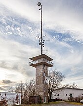
The Hohe Asch with the aerial of the observation tower |
||
| height | 371.5 m above sea level NHN | |
| location | near Bösingfeld ; Circle lip ; North Rhine-Westphalia , Germany | |
| Mountains | Lipper mountain country | |
| Coordinates | 52 ° 3 '21 " N , 9 ° 8' 55" E | |
|
|
||
| particularities | Hohe Asch observation tower | |
The (also: the) Hohe Asch is 371.5 m above sea level. NHN high mountain of the Lipper mountains . He is Bösingfeld in Lippe , North Rhine-Westphalia . The Hohe Asch observation tower is on the mountain .
geography
location
The Hohe Asch rises at the seam line of the Lipper Bergland to the northeastern Weserbergland in the Teutoburg Forest / Eggegebirge Nature Park . It is located about 2 km southeast of Bösingfeld , the administrative seat and at the same time the largest village in the municipality of Extertal , in the southeastern municipality. To the south-east of the mountain is the village of Reine (with districts in Extertal and Aerzen to the east ) and to the south-west of the hamlet of Hummerbruch . The border with Lower Saxony lies around 1.8 km east of the summit . The mountain is forested in its eastern part.
Natural allocation
The Hohe Asch belongs to the natural spatial main unit group Upper Weserbergland (No. 36), in the main unit Lipper Bergland (364) and in the subunit Eastern Lipper Bergland (364.2) to the natural area Alverdissener Heights (364.23).
Mountain height
The height of the Hohe Asch ( 371.5 m ), the summit of which is not precisely defined on topographical maps , is next to a water reservoir , is given in such maps by the Federal Agency for Nature Conservation (BfN) as 370.6 m , which refers to the altitude of Water tank located branch. A trigonometric point ( 366.3 m ) is located around 85 m west of the observation tower on the summit region .
Flowing waters
In the valley to the north of the Hohen Asch, the western Exter tributary Aschbach flows through Bösingfeld, fed by two streams rising on its northwest flank, the small Beberbach tributary Heimbach rises on its northeastern branch of the Vossberg ( 251.6 m ) and the eastern Weser rises on its southwest flank -Influx Humme .
Protected areas
Parts of the nature reserve (NSG) Heimbachtal (NSG no. 378207; designated 2007; 1.0202 km² in size) extend to the lower part of the northeast flank of the Hohe Asch and, apart from the southern flank near the summit, those of the NSG Hummerbachtal (NSG no. 329457; 1994; 67.88 ha ). Parts of the landscape protection area (LSG) Ostliches Lipper Bergland (CDDA no. 555552916; 2007; 69.5663 km²) extend to the summit region and the LSG Terrassenkulturlandschaft north of Hohe Asch (CDDA no. 555553128; 2007; 39, 83 ha).
Observation tower
About 100 m west-southwest of the summit of the Hohe Asch, a 15 m high observation tower made of reinforced concrete has stood since 1980 , from which one can not only overlook some districts of Extertal, because next to the Weser Uplands (from south to east to northwest) with the northwest at the Porta Westfalica standing Kaiser Wilhelm monument are among other things with the Köterberg ( 495.8 m ) in the south-southeast the highest mountain of the Lipper Bergland, in the south-southwest the Eggegebirge and in the southwest to the west the Teutoburg forest with the Hermannsdenkmal (a Detmold landmark) see. When visibility is good, the Brocken ( 1141.1 m ) can be seen in the Harz Mountains .
Traffic and walking
To the west past the Hohen Asch, the district road 57 leads from Bösingfeld through Hummerbruch to Alverdissen.The 106 km long Dingelstedt path , the 54 km long Extertal path , the 72 km long Hansaweg and the European long-distance hiking trail E1 run over the mountain summit and past the tower .
Web links
Individual evidence
- ↑ a b c d Topographical Information Management, Cologne District Government, Department GEObasis NRW ( information )
- ↑ a b Map services of the Federal Agency for Nature Conservation ( information )
- ↑ Hohe Asch panorama adventure tower, on nordlippe.de


