
Quirks
|
Quirks
City of Oerlinghausen
Coordinates: 51 ° 58 ′ 19 ″ N , 8 ° 41 ′ 35 ″ E
|
||
|---|---|---|
| Area : | 2.17 km² | |
| Incorporation : | April 1, 1957 | |
| Incorporated into: | Helpup | |
| Postal code : | 33813 | |
| Area code : | 05202 | |
Location of Mackenbruch in North Rhine-Westphalia |
||

Mackenbruch is a small village in the Helpup district of the city of Oerlinghausen in the Lippe district in North Rhine-Westphalia . Until March 1957, Mackenbruch was an independent municipality in what was then the Lemgo district .
Geography and history
Mackenbruch lies on the northern edge of the Teutoburg Forest . Its settlement core extends along Mackenbrucher Straße and Bergstraße . Since the mid-19th century was the community Mack break in Lippe Office of Administration Schötmar resulting from the same peasantry had emerged. On April 1, 1957, the Mackenbruch community was merged with the Währentrup community and part of the Wellentrup community to form the new Helpup community. Helpup in turn was incorporated into the city of Oerlinghausen on January 1, 1969.
Population development
Census results
| year | Residents | source |
|---|---|---|
| 1871 | 425 | |
| 1880 | 454 | |
| 1895 | 472 | |
| 1910 | 451 | |
| 1925 | 536 |
| year | Residents | source |
|---|---|---|
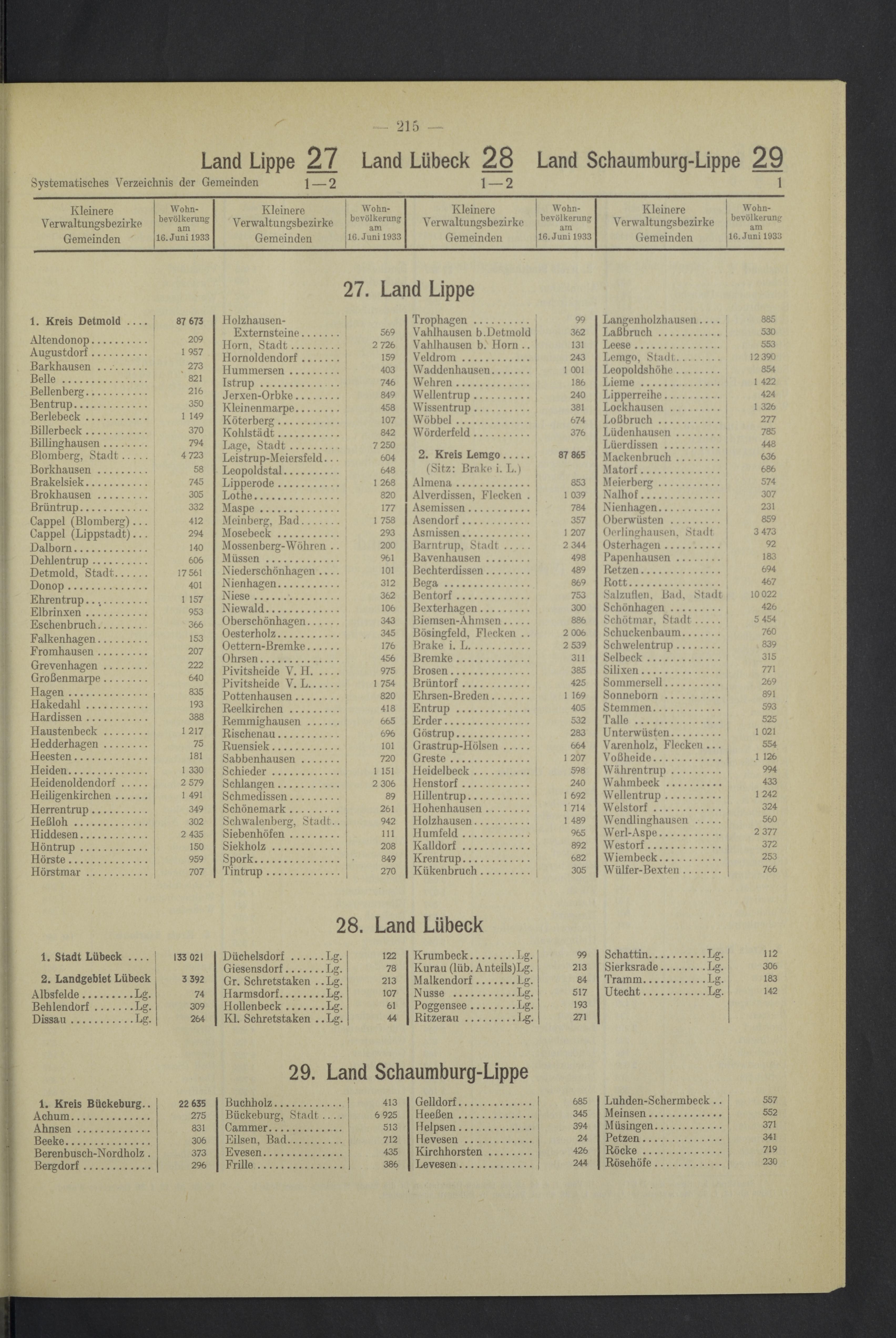
| 1933 | 636 | |
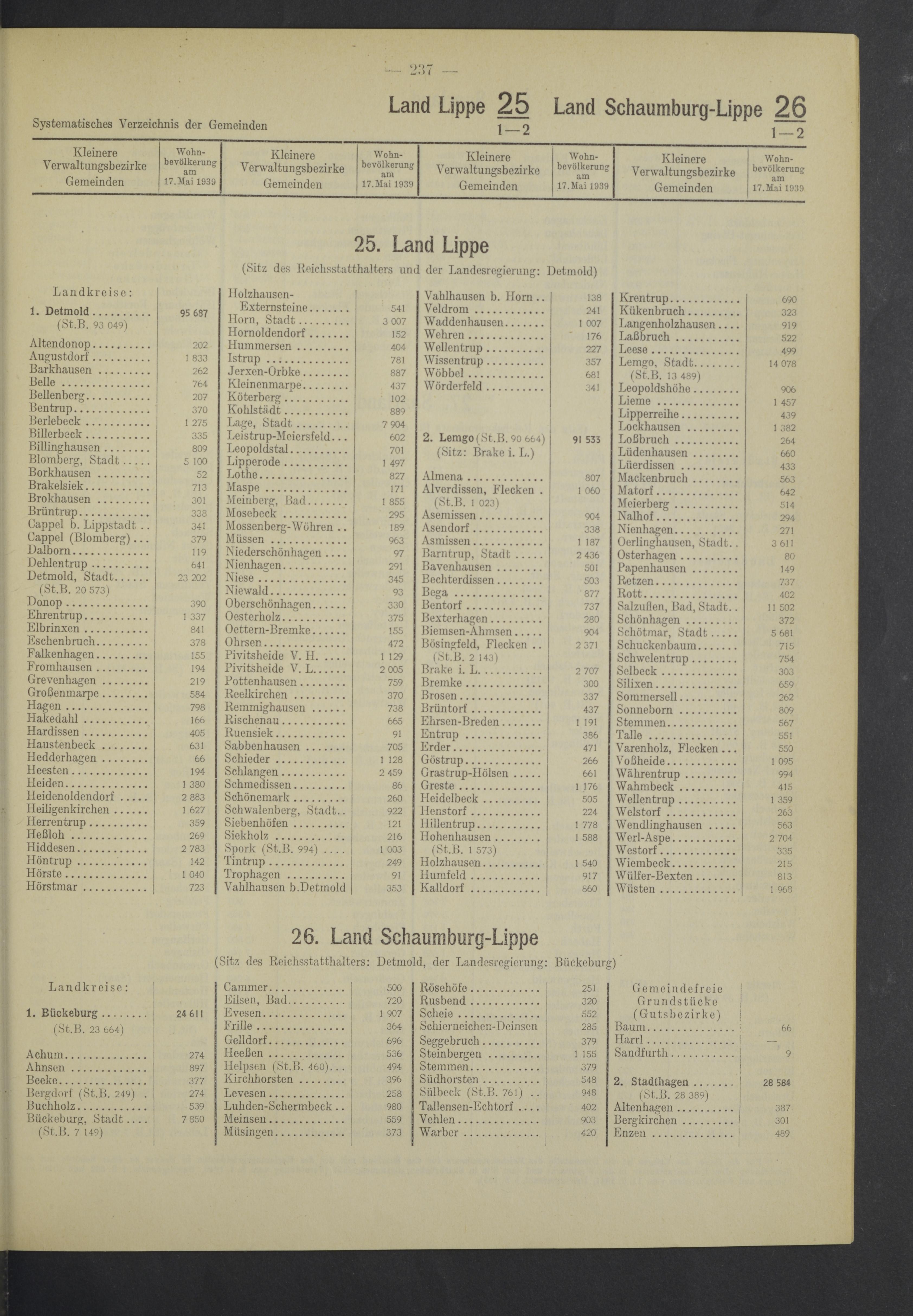
| 1939 | 563 | |
| 1946 | 698 | |
| 1950 | 804 | |
| 1956 | 941 |

Individual evidence
- ↑ a b Directory of the Principality of Lippe, 1875
- ↑ Locality directory of the Principality of Lippe 1882
- ↑ Locality directory of the Principality of Lippe 1898
- ^ Locality directory of the Principality of Lippe 1911
- ^ Michael Rademacher: German administrative history from the unification of the empire in 1871 to the reunification in 1990. lemgo.html. (Online material for the dissertation, Osnabrück 2006).
- ^ Official register of municipalities for the German Reich 1933, p. 215
- ^ Official register of municipalities for the German Reich 1939, p. 237
- ↑ Population and occupation census in the four zones of occupation and Greater Berlin, Alphabetical Municipal Directory, p. 117
- ^ Federal Statistical Office (ed.): Official municipality directory for the Federal Republic of Germany. Final results after the census of September 13, 1950 (= Statistics of the Federal Republic of Germany . Volume 33 ). W. Kohlhammer, Stuttgart / Cologne 1952, p. 78 ( digital version [PDF; 27.1 MB ]).
- ↑ Statistisches Bundesamt Wiesbaden (Ed.): Official municipality register for the Federal Republic of Germany - 1957 edition (population and territorial status September 25, 1956, for Saarland December 31, 1956) . W. Kohlhammer, Stuttgart 1958, p. 237 ( digitized version ).