
Ratheim
|
Ratheim
City of Hückelhoven
Coordinates: 51 ° 4 ′ 3 ″ N , 6 ° 10 ′ 38 ″ E
|
|
|---|---|
| Height : | 48 (40-82) m |
| Area : | 27.48 km² (with Hückelhoven) |
| Residents : | 9355 (June 30, 2018) |
| Population density : | 340 inhabitants / km² |
| Incorporation : | 1935 |
| Postal code : | 41836 |
| Area code : | 02433 |
 Hückelhoven city area, area of the former municipality of Ratheim highlighted
|
|


Ratheim is with about 9,200 inhabitants (as of June 2016) the second largest district of the city of Hückelhoven (municipality name from 1950 to 1971 "Hückelhoven-Ratheim"). The village is located in the district of Heinsberg , the westernmost district of North Rhine-Westphalia , and is about 10 km from the German-Dutch border.
Originally shaped by agriculture and the traditional handicrafts of the Rur valley such as shoemaking , basket weaving and clog making , in the 19th century also home weaving , the development of the place in the 20th century was significantly influenced by the shoe industry and coal mining .
geography
location
Ratheim lies in the lowland of the Rur and extends from the Rurufer in the southwest to the rise of the Rurgraben in the northeast.
The focus of the built-up areas is on the central terrace of the Rur (approx. 50 m above sea level). Since the decline in floods as a result of the river straightening, the area of the low terrace (40 m above sea level) has also been used for residential development. The increasing demand for living space from the 1960s onwards also led to the construction and constant expansion of the “Am Bammich” housing estate, which extends on the edge of the Rurgraben to a height of around 82 m above sea level.
The eastern edge of the Rur valley represents an approximately 50-60 m high, relatively steep rise in terrain, which is largely forested and divided by stream valleys; it belongs to the landscape of the Wassenberger Riedelland . The Ratheimer Bergehalde hugs it , which still clearly towers above it with a height of 140 m above sea level.
geology
The middle and lower Rurtal represents a rift valley that is bounded east of Ratheim by the Wassenberger Horst . Along its fault lines - especially the southwestern one - seismic activity can be observed up to modern times . Since 1979, one or more tremors have been recorded here every year , but mostly so weak that people do not notice them. The last earthquake with a magnitude of 5.9 on the Richter scale was registered in Ratheim on April 13, 1992.
See also: Cologne Bay earthquake area
In the subsurface of the Wassenberger Horst, in particular, there are several layers of carbonaceous carbon containing hard coal (formed 360–300 million years ago), which were created by the Sophia-Jacoba colliery, for example. Some of them have been mined - initially levels 1 and 2 at a depth of 270 m and 360 m, respectively, later coal fields located much deeper. The mining below Ratheim took place in the 1960s and 1970s.
The so-called Ratheim layers are named after the place : sandy deposits from the upper Eocene that were formed 34 million years ago and can be found in isolated cases in the Rhine-Meuse region (e.g. near Erkelenz).
Quaternary deposits of fluvial sands and gravels from the period of the last 2.6 million years are widespread in the entire lower Rur valley and can also be found near Ratheim. They have been partially dismantled, which u. a. led to the creation of Lake Adolfo.

landscape
The landscape around Ratheim (as in the towns of Millich, Hilfarth and Brachelen, which are also located on the Rur) is one of the typical floodplain landscapes in the greater Cologne Bay landscape , while the other parts of the city of Hückelhoven also predominantly have bordelike landscapes typical of the Cologne Bay .
As far as the outskirts, the village is surrounded in the northeast and southwest by the foothills of the international Maas-Schwalm-Nette nature park . The Adolfo lake belonging to it and its bank areas are designated as a landscape protection area.
Waters


-
Rur
- Until 1827 the Rur, which at that time was a rather unpredictable, at times wild river, could only be crossed by ferry near Ratheim. Then, by order of Count Spee zu Düsseldorf, to whom the neighboring Ohof belonged at the time, the tenants built a wooden bridge over the Rur. The bridge was privately managed until it was replaced by a public concrete bridge after World War II.
- The lower Rur was straightened in 1966 . In addition to the construction of weirs and bottom slides , the river bed was given a trapezoidal profile that appeared suitable for the rapid forwarding of flood waves. Until then almost always occurred in spring flooding of the flood plain by floods , which mainly for residents of Heinsberg- Oberbruch a problem had shown, since here only the exception. However, the non-straightened Dutch areas of the river are disadvantaged.
- As part of the RIPARIA project, two weirs were dismantled in the Ratheim / Millich area in 2001 and the course of the river made more natural again, creating additional retention space for floods. The two sections of the river, each of which contains an oxbow lake, were intended for natural floodplain development.
- Adolfosee , a quarry pond , which is caused by gravel mining in the 1960s to the 1980s
- Mühlenbach (also "Gendorfer Bach", "Gerderather Bach", "Bohlbach", "Baaler Bach")
- The Mühlenbach with its accompanying green belt, the green lung of Ratheim, runs open and z. Partly renatured from Gendorf to the village center, which is followed by a short, piped stream section. Until 1952 he fed a mill pond near the old Ratheimer mill; On the Tranchot map from 1806 there is another pond fed by the brook below the parish church.
- Originally the Mühlenbach followed the edge of the lower Rur terrace in a westerly direction and flowed into the Rur behind Garsbeck. In the first expansion phase of the Ratheim sewage treatment plant at the beginning of the 1970s, the brook was channeled and diverted to the south in order to be able to serve as a receiving water ; its confluence with the Rur was placed near the Adolfo lake.
- Pützbach (also "Mottbach")
- Since its relocation, the original stream bed of the Mühlenbach has been fed by the water from the Silberquelle, which flows off as the Pützbach in a westerly direction. Thus, at Ratheim there is the strange and artificial phenomenon that two streams cross each other .
- Source of silver
- The Pützbach, which leads via Garsbeck and Vogelsang to the Rur, rises in the legendary silver spring in the Hallerbruch.
- Castle pond of Haus Hall
Districts
In addition to the town center, there are a number of districts that mainly go back to late medieval settlements: Busch, Faulendriesch, Garsbeck, Gendorf, Hagbruch, Krickelberg , Ohof and Vogelsang.
The districts "Siedlung" and "Bammich" emerged in the 1930s and after the Second World War.
Historic individual settlements in Ratheim are Haus Hall and Mahrhof .
Neighboring places
In the vicinity of Ratheim are:
- Altmyhl , 2 km north of Ratheim
- Kleingladbach , 3 km northeast
- Schaufenberg , 2 km to the east
- Millich , 2 km southeast
- Porselen , 3 km south
- Oberbruch , 2 km west-southwest
- Interruption , 4 km to the west
- Wassenberg , 4 km northwest
history
Place name
The name Ratheim is likely to be of Franconian origin. Place names on “-heim” are the primary settlement names in the region , they were mainly used in the first phase of the Frankish conquest (from the 6th century). In the Lower Rhine area, “home” names indicate the origin of a single farm.
For the interpretation of the place name, several interpretation hypotheses come into question:
-
Home on the swamp
- after the old high German red (rot) or the Dutch red (swamp); this would be justifiable not only linguistically, but also historically and topographically, since the swamps near the church are mentioned in a deed of donation from 1305.
-
Home of Ruth
- after the name of the first settler; alternative Franconian names would be Rother , Roticar or Rothard . The more conveniently pronounced Roathem or Rotheim could then have emerged from “Rotharheim” .
-
Home of the redhead
- according to a characteristic of the first settler
-
Home on the clearing
- Many place names in the region, especially in the area of the former district of Erkelenz , end in "-rath" (Old High German riuten = clearing) and can be traced back to clearing ; However, they are considered secondary settlement names and were mainly established in the region during the high medieval clearing phase.
The following names have been handed down in writing: Rotheim , Rothen , Rotheym , Roetheym , Roithem , Rathem , Rhatheim ; in today's Ratheimer Platt , the village is called Roathem .
Nickname
The residents of the neighboring towns gave the people of Ratheim the nickname " Roathemer Wenk ..." (sometimes with the addition: "... dä stänkt "). This "Ratheimer Wind ... which stinks" has been used as a synonym for "self-praise stinks" until recently . Today the nickname lives on in the name of one of the two Ratheim carnival clubs.
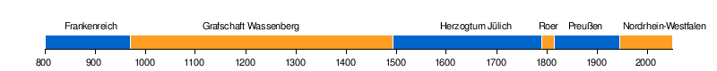
time beam
Political affiliation with Ratheim
Roman Catholic affiliation

Old story
Settlement of the Ratheim area goes back to Roman times (before 450 AD). A Roman road leading from Venlo to Düren (and on to the Moselle) ran along the right bank of the Rur and touched Ratheim (today's L117 road also runs in this direction; in the Ratheim area it is called "Heerstraße"). Finds of Roman coins between Ratheim and Myhl and the discovery of old Roman tiles in the substructure of the Ratheim church “St. John the Baptist ”are indirect evidence of the early settlement. A relationship between this settlement and the medieval village of Ratheim cannot be proven.

The Romans during the great migrations following Franken came about in the 6th century in our room. As cattle breeding farmers, they preferred to settle on lighter soils and near water. They found these conditions in the Ratheim area on the edges of the Rurterrassen and in the small stream valleys - but they stayed away from the swampy Ruraue, which is threatened by annual floods. The discovery of a Frankish kink pot between House Hall and Ratheim-Busch, the appropriate rate as Frankish place name as well as the as the Merovingian existing patronage ( John the Baptist ) support this early settlement directly or indirectly. The old town center of Ratheim is the area between Mühlenstraße and Kirchstraße and includes the parish church standing on a spur. But there were also a large number of other settlement centers that z. In some cases, the following were largely merged with one another only in the 20th century: Berg, Busch, Faulendriesch, Garsbeck, Gendorf, Hagbruch, Kobbendahl, Krickelberg, Mahrhof, Ohof, Venn and Vogelsang. The neighboring settlements of Millich and Schaufenberg also belonged to the parish and mayor's office of Ratheim until the 20th century.
The earliest indirect mention of Ratheim dates from a Cologne document from 1176 in which a Johannes von Rotheim is mentioned. This mention cannot be clearly assigned to the village, but later names can be (e.g. from 1202). Ratheim itself is first mentioned in a document from 1296 as " villula dicitur Rotheym " ( little village called Ratheim) and at that time had 305 inhabitants.
In the Middle Ages and early modern times , Ratheim belonged to the County of Wassenberg and from 1494 to the Wassenberg Office in the Duchy of Jülich ; the parish belonged to the diocese of Liège .
French period
In 1794 the French conquered the Rhineland , u. a. with the aim of making the Rhine their “natural” border. On October 2, 1794, a great " Battle of the Rur " took place along the Rur between Orsbeck and Düren , in which 120,000 French people faced each other on the left bank of the Rur and 100,000 Austrians and Prussians on the right bank. The military road leading from Maastricht to Neuss crossed the Rur near Ratheim, which is why this point was of particular strategic importance. The commander of the French vanguard, Jean-Baptiste Bernadotte , who later became King of Sweden, forced the crossing over the Rur at the "Schanz" near today's Rurbrücke, which is seen as a decisive factor in the conquest of the Rhineland.

In 1801, after the Treaty of Lunéville , the French annexation of the Rhineland was recognized under international law - Ratheim was officially part of France until 1814 ; French became the official language.
The administration had already been reformed in 1798 according to the French model. Ratheim received its own mayor's office (" Mairie "), which belonged to the Rur department ( Département de la Roer - Arrondissement Aachen - Canton Heinsberg). In 1802, the parish was assigned to the newly founded (“first”) diocese of Aachen , which was established at the instigation of the French authorities and probably against the will of the Pope. On July 16, 1821, this diocese was dissolved again by the Pope with the bull De salute animarum and - of course, together with the Ratheim parish - it was incorporated into the Archdiocese of Cologne.
After the resolutions of the Congress of Vienna , Ratheim came under Prussian rule in 1815 and became mayor in the newly formed Heinsberg district, which initially belonged to the province of the Grand Duchy of Lower Rhine , and from 1822 to the Rhine province .
Younger story
After the First World War, Ratheim was occupied by Belgian and French troops. At first, the population did not notice much of this occupation, but this changed significantly from 1923 onwards with the emergence of passive resistance . The population was particularly affected by the economic effects of the strikes, but the banishment of unpleasant people to the other side of the Rhine or the military occupation of the Ratheim train station also created discontent. The occupation lasted from 1918 to 1929.
On October 1, 1932, Ratheim was spun off from the Heinsberg district and assigned to the Erkelenz district, which was dissolved in 1972 and became part of today's Heinsberg district.
In 1935, Ratheim, which at that time already had 5282 inhabitants, was merged with the villages of Hückelhoven, Kleingladbach and Hilfarth to form a new municipality (the four stars in the Hückelhoven coat of arms are reminiscent of these four founding municipalities). To the displeasure of the Ratheim residents, the community was given the name Hückelhoven, which at the time had the smaller population, but with Friedrich Honigmann and the Sophia-Jacoba colliery the larger business lobby. Hückelhoven was also designated as the seat of the council and administration, although Hückelhoven at that time (unlike Ratheim) did not even have a town hall.
In 1950 the community was then named Hückelhoven-Ratheim and in 1969 it was promoted to town. On January 1, 1972, however, the double name was given up again; the city has been called Hückelhoven since then . This laid the foundation for the rivalry between the two districts that can still be felt today.
National Socialism and World War II
The majority Catholic population of Ratheim was rather hostile to National Socialism. A number of residents who rejected the Nazi regime for Christian reasons were on the Nazis' “black list” (e.g. Bernhard Meurer or Wilhelm Jansen). Peter Schlebusch reports that he was able to warn some of these people.
Nevertheless, the rulers of National Socialism were courted in Ratheim: The market square was named Adolf-Hitler-Platz , here was the Brown House , the Nazi party headquarters. Myhler Strasse was turned into Dr. Renamed Frick-Strasse .
Two Jewish families lived in Ratheim in the 1930s. Contemporary witnesses report that in front of the Hermanns family's shop on Vennstrasse, an SA formation came up and sang mock songs.
It is also orally transmitted that Maria Winkens heard loud complaints in Hermann's house on her way back from the church. She went into the house and learned that the owner of the house had died. That she comforted the widow was badly criticized by the Nazis.
In the so-called Reichspogromnacht on November 9, 1938, the house of the Ratheim family Löwenstein in Busch was set on fire; the neighbors were outraged but did not dare to help. Walter Löwenstein was later deported; he survived the concentration camp and returned to Ratheim after 1945. Since his health was badly damaged by the imprisonment, he died in 1948.
Another Nazi victim in Ratheim was KPD member Max-Willi Schade. He died in 1944 in the Düsseldorf concentration camp, according to Johannes Bürger of exhaustion, according to Peter Schlebusch he was "shot while trying to escape" (a euphemism with which the Nazis tried to publicly gloss over the murder of their victims).
Ratheim was in advance of the fighting on the Rurfront been strongly fortified with bunkers and positions along the Rur and on the heights of Rurgrabens. As the Allied troops approached the Rur, the Ratheim Rurbrücke was blown up by the German Wehrmacht and the population was forcibly evacuated from September 12 to 14, 1944; only a few residents z. B. the Volkssturm or the emergency occupation of the colliery initially remained behind and were only removed in January 1945. After the evacuation, House Hall was used by the staff of the German Wehrmacht as quarters; the plans for the Battle of the Bulge are said to have been worked out here.
On the Rur, the front came to a standstill for several weeks, also as a result of the Ardennes offensive. During this time Ratheim was under heavy artillery fire. Eyewitnesses report that when the residents returned, none of the houses had an undamaged roof or window panes.
The for the 9./10. Feb. 1945 planned Allied operation grenade that should force a crossing of the Roer, was defeated by the Germans, by the bottom outlet cleats of Rurtalsperre were blown up. As a result, the entire Rur valley was flooded; the level rose by up to 3 m and the Rur widened in places to several hundred meters.
It was not until two weeks later that the Allies were able to cross the still raging river with great difficulty. The “spearhead” of the American troops, the 102nd US Infantry Division, crossed the Rur near Rurdorf on February 23, 1945 and fought its way towards Erkelenz and Krefeld without flanking.
On February 25, 1945, American troops of the 134th Infantry Regiment captured Hilfarth, the last German bridgehead west of the Rur, crossed the river over the damaged but still passable Hilfarth Bridge and followed the course of the Rur towards Roermond.
On February 26, 1945, the German troops were withdrawn from the region and relocated behind the Rhine, so the conquest of Ratheim (on February 26/27, 1945), as well as the rest of the Rhineland, went without major problems for the Allies. While the 1st Battalion remained in reserve in Hilfarth, the 3rd Battalion advanced through the Hückelhovener Siedlung, Schaufenberg and Busch to Gendorf, removed the anti-tank barriers there and moved on towards Wassenberg. The 2nd battalion on their left flank cleared Doverack, Ratheim, Krickelberg, Vogelsang, Garsbeck, Luchtenberg and Orsbeck.
Shortly afterwards an American headquarters was set up at House Hall, which was handed over to the English a few weeks later. They installed the central administration for the district of Erkelenz and - soon afterwards - also for the district of Geilenkirchen-Heinsberg.
From March 1945 the first inhabitants of Ratheim returned to their devastated hometown. 197 Ratheimers lost their lives as a result of the war.
Population development
- 1296: 305
- 1825: 1706 (municipality of Ratheim, including Millich and Schaufenberg)
- 1852: 2092 (municipality of Ratheim, incl. Millich and Schaufenberg)
- 1900: 2399 (municipality of Ratheim, incl. Millich and Schaufenberg)
- 1925: 3470 (municipality of Ratheim, incl. Millich and Schaufenberg)
- 1935: 5282
- 1965: around 8000
- 2006:> 9000 (as of spring)
- 2007: 8913 (as of January 31, 2007)
- 2014: 8977 (as of June 30, 2014)
- 2016: 9198 (as of June 30, 2016)
religion
At the beginning of the 20th century Ratheim had about 2400 inhabitants. The vast majority of them were Catholic ; there were only a few evangelical reformed families. With the economic upswing of the place associated with the establishment of the Sophia-Jacoba colliery , there was an increased settlement of non-local workers, many of whom came from Protestant regions of Germany.
Today (as of 2006) around 5000 Catholics live in Ratheim according to the mission and structure plan of the Aachen diocese; the numerical ratio of Catholics to Protestants is about 2: 1.
The Catholic Church is dedicated to St. John the Baptist , the Protestant church building is the Peace Church .
Culture and sights
Buildings


-
Catholic Parish Church of St. John the Baptist
- The parish church, which is mainly presented in simple Gothic or neo-Gothic forms, has a complex architectural history. The time of the first church building is unclear. The earliest documented mention dates back to the year 1305, but today's central nave was built on the foundations of a hall church, which was probably built in Franconian times. Central nave, south aisle and the substructure of the tower date from the 15th century. The superstructure of the tower was carried out in the 17th to 18th centuries. The building was then enlarged considerably in the 19th century according to plans by Friedrich von Schmidt ; the late Gothic choir was demolished and a large transept with a new choir was added to the old nave instead. Another extension of the church took place in 1972 with the construction of a north aisle.
- Schenkelesberg, a moth , is an extension of the Schröverweg on the edge of the Rurgraben.
-
House Hall
- House Hall is a mainly dating from the 18th century, waterlocked plant, consisting of the mansion and located to the mansion opening towards three-winged front castle . The outer bailey has a gate on each of its narrow sides with a basket arched passage and a hipped roof adorned with high knobs on the coffins. The manor house, which is now three-winged, initially only consisted of the five-axis central wing, the two two-axis corner buildings were only built at the beginning of the 20th century.
- The earliest documented mention dates from 1248, when a Gottfried von Hall is mentioned.
- House Palenberg from around 1675
- The house on Mühlenstraße (house number 3) originally belonged to the noble Olmissen family and housed a brewery. At the end of the 18th century it was acquired by the Palenberg family, who ran a shop here (until the first third of the 20th century). Until the 1980s it was then used by the general practitioner Dr. Hermann Brüssermann used as a practice. It is still owned by the family today.
- Old town hall from 1868 (under monument protection since 1985)
- Administrative branch of the city of Hückelhoven until the 1980s; Meanwhile, civil weddings are carried out here again (by appointment)
- (Former) coal washing plant of the Sophia-Jacoba colliery :
- The circular building has a diameter of 110 meters. In the EXPO year 2000, ICE multiple units of the ICE-DT type were temporarily put into operation on the access tracks.
- Rur bridge between Oberbruch and Ratheim (for pedestrians and cyclists)
- Since the wooden bridge from 1986 collapsed in June 2005, the Rurufer cycle path , which crosses the Rur near Adolfo Lake, has been interrupted here. At the same location, a new bridge made of Bongossi wood was built in autumn 2006 with funds from the state of North Rhine-Westphalia, the district of Heinsberg and the cities of Hückelhoven and Heinsberg and was inaugurated on November 21, 2006. Their span is 33 m, the width 2 m.
- former watermill
- Today (as of 2007) the mill pond serves as a marketplace for Ratheim.
Monuments
- Eight crosses mark the old Ratheim settlement centers
- These are processional crosses on which mass is held on Corpus Christi day. The oldest surviving cross is in Hagbruch and dates from 1771, the youngest cross (Buscher Siedlung) was not erected until after the Second World War.
- War memorial on the village square
- The older part of the monument was erected under National Socialist rule. It consists of a concrete column with a cross and a concrete wall with a cross for each Ratheimer who died in the First World War.
- After the Second World War, an octagon was added to the memorial containing panels with the names of those who died in both world wars. A wreath-laying ceremony takes place here every year on the day of national mourning.
- Sculpture mother with child (?) On the market square
- The bronze sculpture of a mother putting a shoe on her child was designed by the Eynatten- based artist Prof. Wolfgang Binding . It is intended to remind of the long tradition of the Ratheim shoemaking trade.
- Sculpture John the Baptist ... and YOU?
- The bronze sculpture of the parish priest John the Baptist , who calls people to repent, was designed by the Ratheim sculptor Gert Jäger. It stands in the area between the parish church and the parish hall.

- Coal train
- Another memorial reminiscent of the Sophia-Jacoba colliery is a former coal train (for use underground) at the Ratheim motorway entrance.
- Memorial stone for the Sophia-Jacoba colliery
- The boulder with the inscription "Sophia-Jacoba Schacht 4/6" stood in the entrance area of the Ratheim central shaft system until 1997. Today it decorates the roundabout near Faulendriesch.
Regular events
- Storming of the town hall (on Altweiber Thursday)
- On Fat Thursday, the mayor of Hückelhoven visits the old town hall of Ratheim so that it can be stormed by the members of the Ratheim carnival clubs and the Möhnen .
- Carnival parade (on Tulip Sunday )
- Tanz in den Mai (April 30th), organized by the Ratheim fire brigade
- Shooting festival / bird shot of the Ratheimer Schützenbruderschaften (on Ascension Day )
- Riding tournament of the Ratheim riding and driving club with euregional importance (on the Whitsun weekend )
- Parish and patronage festival of the parish of St. John the Baptist (every two years at the end of June)
-
Late fair with parade of the rifle brotherhoods (on the last Sunday in August)
- The traditional early fair has been canceled by the Hückelhoven city administration.
- Marian pilgrimage to Ophoven (on the first Sunday in September)
- Settlers festival of the Busch-Bammich interest group (in September)
- Adolfo run (in autumn)
- Hoppeditz awakening (on the first Saturday after November 11th)
- Annual gymnastics of the TV Hückelhoven-Ratheim (on the 1st of Advent)
Many of the Ratheim local associations and groups have formed a working group that announces its events on its own homepage.
Art and music
- Church choir "St. John the Baptist"
- The church choir was founded as "Gesangverein Cäcilia" in 1834, after another mention in 1850 (both mentions are uncertain because the old chronicles of the choir are lost)
- Art association CANTHE
- Exhibitions in the old town hall of Ratheim
- Music association "St. Josef “Ratheim e. V. from 1910
- Singing circle of the Protestant parish Ratheim-Gerderath from 1969
- Drummer and wind corps "Vorwärts" Ratheim-Busch e. V. from 1952
Social infrastructure
childcare
There are four kindergartens in Ratheim:
- Catholic family center “St. John the Baptist “Danziger Strasse
- Catholic day care center Mühlenstrasse
- AWO Kindergarten Ratheim
- Integrative day care center run by Lebenshilfe Heinsberg e. V. "TRIANGEL" Ratheim, Im Weidengrund
Since 1990 there has also been a dormitory for underage mothers and their children on Neu-Hall, an institution of the Caritas Association of the Heinsberg region.
In 2004 an “adventure playground” was completed on Mühlenstraße in the village center.
education
At the beginning of the 1950s, a school center was built in Ratheim that spatially combines three types of school:
- Elementary School Ratheim (today Michael-Ende-School , formerly Catholic elementary school Ratheim )
- Carl-Friedrich von Weizsäcker secondary school in Ratheim (since August 30, 2008, previously: Community secondary school in Ratheim) - was discontinued at the end of the 2010/2011 school year. The remaining students were taken to the Hückelhoven secondary school.
- Leonardo da Vinci comprehensive school Hückelhoven in Ratheim (replaces the secondary school in Ratheim since the beginning of the 2011/2012 school year)
- Realschule Ratheim
This "school village" has expanded over time and was expanded to include a teaching pool (no longer in use) and a gym, which was expanded into a multi-purpose hall in 1976. There is also a small gym, which is mainly used by the primary school and carnival clubs for events. f At the moment (2009–2017) the school center is being completely gutted in several stages and partially rebuilt. The work is currently, February 2017, nearing completion.
The high school of the large community of Hückelhoven-Ratheim was also located in Ratheim in its development phase from 1963 to 1969.
With the increase in the number of inhabitants, the construction of a second Ratheim elementary school became necessary in 2001/2002, which is located in the Busch-Bammich area, the elementary school Im Weidengrund .
Civil protection
Volunteer firefighter
The Ratheim fire fighting group has a fire engine (HLF 20/16) and a dangerous goods equipment vehicle (GW-G) that belongs to the environmental protection train of the Hückelhoven volunteer fire brigade . Both vehicles are housed in the fire station on Jacobastraße.
The fighting group is responsible for the day the places Ratheim, Krickelberg, Garsbeck, Vogelsang and Altmyhl and by the full-time staff of firefighters Hückelhoven and the company fire the company QVC supported (Baal). In the event of traffic accidents and other larger operations on the A46, the fire fighting group is also alerted to train 1 (Hückelhoven). In the event of major damage and environmental protection, it is used throughout the city or in the region.
technical aid organization
The local branch Hückelhoven of the Federal Agency for Technical Relief ( THW) is located in Ratheim. In addition to carrying out general tasks of the THW, this local association specializes in particular in building supports and clearing operations with heavy equipment and thus frequently provides administrative assistance to the fire brigade regionally and nationally. The building support system ASH (formerly FRABLO), which has been introduced nationwide, was developed in the Hückelhoven local association.
technical infrastructure
traffic
Street
Since the expansion of the A 46 Heinsberg - Düsseldorf (“Selfkantstraße”) in 1995 from the then end point Hückelhoven to Heinsberg, there has been a junction between Ratheim and Millich (with the name “Hückelhoven-West / Wassenberg”, which is very unpopular with the people of Ratheim).

Ratheim belongs to the Aachener Verkehrsverbund (AVV). Bus routes 401, 402, 406, 407 and 495 run through the town; there are 14 bus stops. The central meeting point for these lines is the Ratheim Schulzentrum stop .
The traffic is mainly geared towards the transportation of schoolchildren, so the bus service does not follow a uniform schedule. While traffic currently (2017) ends on weekdays at around 10:30 p.m., there is only a very limited range of tickets on weekends. In Ratheim line 401 runs from Heinsberg via Hückelhoven, Doveren and Hetzerath to Erkelenz and line 402 runs from Erkelenz via Ratheim and Dremmen to Heinsberg. In order to be able to offer transport services in off-peak times, one relies on the multi-bus.
Until the railway line was built, it was common to use stagecoaches to transport people . In 1863, the previous Kariolpost Wassenberg-Baal (i.e. luggage transport with limited passenger transport) was converted into a personal mail. A two-horse, six-seater carriage could get from Wassenberg to Baal station in 90 minutes. Post stations were Haus Weith in Gendorf, the Buscherhof in Busch, Haus Worms in Millich and Haus Louis in Doveren. In 1872 the Kariolpost Erkelenz – Hückelhoven was also canceled and converted into a Wassenberg – Lövenich passenger mail route.
rail


A railway line, the Jülich - Dalheim railway, ran between 1911 and 1980 from Baal via Hückelhoven, Ratheim and Wassenberg to Dalheim . After the cessation of passenger traffic, it only served the freight traffic of the Sophia-Jacoba colliery between Ratheim and Baal, the tracks to Wassenberg were dismantled in April 1985. The railway line crossed Ratheim with several tracks. At the end of the village there was an eight-track works station that was used by the briquette factory located in Hückelhoven.
The Ratheim station was for a long time the most important station in the Hückelhoven city area next to the Baal station due to the strong freight traffic and the branching off connections to the Sophia-Jacoba colliery ; Ratheim train station once had 14 civil servants and freight traffic reached up to 60,000 freight wagons per year (e.g. 1987). There were four to six so-called "program trains " ( DB ) per day (additional freight trains if required) and internal transports between the mine site in Ratheim and the processing (briquette factory) in Hückelhoven almost every block. As a result of the closure of the underground production of the Sophia-Jacoba colliery, freight traffic also decreased significantly and only two freight trains per week operated sporadically.
In the EXPO year 2000, the coal washing plant of the former Sophia-Jacoba colliery was temporarily used as a processing hall for ICE multiple units, which led to the curious fact that Ratheim station became an "unofficial ICE stop".
In 2009 the railway line, level crossing and signal box in Ratheim were dismantled. It is planned to set up a bypass on this route in the future, which will relieve Ratheim of the traffic that is currently impairing the quality of life in the village to a considerable extent. According to the most recent traffic counts, around 1000 trucks drive through the town every day to reach the Ratheim motorway junction.
shipping
The Rur was navigable in earlier centuries. It represented an important traffic artery for the region and gave the Heinsberger Lands cohesion. Upstream the Rur could z. T. can only be accessed by towing . The paths along the Rur led to the Jülich and Limburger Land.
Supply / disposal
electricity
Ratheim has been electrified since 1911. Today (2017) the technical supply is guaranteed by WestEnergie GmbH .
water
Until 1934 the water supply in Ratheim was ensured by local wells; since then the place has been supplied by public water pipes. Today (2017) the water requirement is covered by the Heinsberg district waterworks from the Uevekoven location .
sewage
In 1933 the sewer system in Ratheim began. In 1959 the Ratheim sewage treatment plant was built, which belongs to the Eifel-Rur water association ; it cleaned the sewage from Ratheim, Kleingladbach and Hückelhoven. After extensive expansions, this sewage treatment plant has been receiving almost all of the wastewater from the Hückelhoven urban area since September 2000. The treated wastewater is discharged into the Rur via the Mühlenbach receiving water .
economy
Shoe industry
In the last quarter of the 19th century, industrialization took hold of the down-to-earth shoemaking trade in Ratheim and led to the establishment of the shoe industry. The first steam-powered shoe factory in the Aachen region was established here.
In the heyday of this industry around the middle of the 20th century there were 10 shoe factories in Ratheim that provided around 600 workers with a livelihood. At that time there were even efforts to establish a shoe school in Ratheim and to give the place the meaning of a “second Pirmasens”.
But it shouldn't come to that. The general decline of the German shoe industry in the 1960s / 70s with the relocation of production to “low-wage countries” also affected Ratheim.
Today (2009) there is only one shoe factory in Ratheim.
Hard coal mining
The “Hückelhoven” colliery began in 1914 with the production of anthracite coal; In 1917 she was given the name " Sophia-Jacoba ".
In 1934, Shaft 4 was put into operation at Ratheim, which initially served as a weather and material shaft. In the mid-1950s, it was expanded into a shaft and, according to plans by the well-known industrial architect Prof. Fritz Schupp, it was provided with a modern and aesthetically pleasing shaft tower made of reinforced concrete, which was put into operation in 1959. Shaft 6 / HK followed in the same style in 1964.
From the 1960s to the 1990s, the Sophia-Jacoba union was considered "the most modern colliery in Europe". In 1979 the central shaft system at Ratheim was expanded to include a leveling system, and in 1983 a coal washer was added.
The coal mine was closed on March 27, 1997, and the Ratheim winding towers were blown up and removed in the following two years. Since then, in addition to the converted administration buildings and two monuments, only the former coal washing plant has been a reminder of this section of Ratheim's history.
Other industries
- Production of concrete pipes
- The "H. Finken cement goods factory" founded in 1906 was initially located in the town center. In the 1970s it was relocated to the outskirts of the town on Kaphofstrasse.
- Production of composite paving stones
- The company "Knorr-Betonwaren", founded in 1938, has specialized in the production of composite paving stones since 1960
- Brick and brick production
- The “Oeben” and “Beckers” ring kilns were located in the area of today's Ziegeleiweg and on the site that is now occupied by Lake Adolfo. They were abandoned in the early and mid-1960s.
- mechanical engineering
- The Stump mechanical engineering factory near the train station existed until the 1970s.
Economic reorientation
Ratheim's growth in the Busch-Bammich area after the Second World War was followed by a relocation of the business center from Vennstrasse, the former main shopping street, to Busch. In addition, when the city became a town (1969), many companies and structures began to be relocated to Hückelhoven.
After the closure of the Sophia-Jacoba colliery, Ratheim and Hückelhoven also underwent economic restructuring towards medium-sized businesses. The interests of the Ratheim companies are represented by the Ratheim trade association.
Current commercial areas in Ratheim (status: 2007) are:
- Ratheim industrial park, Oberbrucher Straße (1.4 ha)
- Intermunicipal industrial and commercial park "Rurtal" Hückelhoven-Wassenberg (100 ha), which is currently being built on the site of the former colliery
Personalities
-
Johann Campanus (* around 1500 in Maaseik , † around 1575)
- Reformer and preacher; In the period between 1543 and 1553 he was kept hidden at Haus Hall by the nobleman Heinrich von Olmissen called Mülstroe in order to prevent his expulsion from the Duchy of Jülich. He preached "secretly and at night" in the Kapbusch between Ratheim, Hilfarth and Dremmen at the so-called Campanus oak .
-
Lambert Hastenrath (* 1815 in Ratheim, † 1882 in Burtscheid near Aachen)
- Portrait painter of the Düsseldorf School
-
Edmund Knorr (* 1885 in Ratheim, † 1979 in Erkelenz)
- Teacher, home curator, nature conservationist and ornithologist who worked in the entire district of Erkelenz at that time; Honorary citizen of Erkelenz
- Peter Schlebusch (* 1887 in Ratheim, † 1968 in Ratheim)
- Ratheim “veteran” and local researcher; he collected information for the Ratheim Chronicle, kept the chronicle of the Ratheim brotherhoods and wrote down his own, highly interesting memoirs
- Maria Winkens born Münstermann (* 1894 in Aachen, † 1973 in Ratheim)
- As a member of the Erkelenz District Assembly for Ratheim, she ensured that 16 church bells from the region, which had been picked up from their home communities shortly before the end of the Second World War and were to be melted down for armament purposes, returned to the Soviet occupation zone after the end of the war in 1949 Could return home. In addition to three bells from Ratheim, she was also able to save bells from Erkelenz, Gerderhahn, Golkrath, Granterath, Kipshoven, Kückhoven, Niederkrüchten, Östrich, Rath-Anhoven and Üvekoven.
- Max-Willi Schade († 1944 in the Düsseldorf concentration camp )
- Works council chairman of the Zeche Sophia-Jacoba and KPD member. He was arrested by the Nazis for the first time in 1933 and spent two years in a concentration camp, after which he had to report regularly to the police in Hückelhoven. In 1944 he died totally exhausted in the Düsseldorf concentration camp. In 1948 the street in the Krickelberg district where he had lived was named after him.
-
Adolf Freiherr Spies von Büllesheim (* 1929 in Ratheim; † February 12, 2011 in Ratheim)
- Mayor of the city of Hückelhoven-Ratheim (1969–1972) and member of the Bundestag for the Heinsberg district (1972–1987); Owner of House Hall; Name giver for the Adolfo lake
- Gert Jäger (* 1956)
- Ratheim sculptor
- Angelika Schierholt (* 1967)
- 2001 became the first woman to become world champion in kick boxing
-
Elke Winkens (* 1970)
- Actress; as Ratheimer Tanzmariechen 5 times German champion and 2 times European champion in "dancing for carnival dances"
- Marcus Ströckens (* 1964)
- Drummer and pop singer with many awards in music competitions
- Wollny family
- Actor of the pseudo-documentary " The Wollnys - A terrible big family ", which is broadcast on RTL2 (2013-2019)
literature
- Johannes Bürger: From the history of the city of Hückelhoven . Own print, Hückelhoven 2005.
- History workshop StadtWandel Hückelhoven (ed.) (2003/2005): We couldn't make any big leaps. Everyday stories from the miners' settlements in Doveren, Hilfarth, Hückelhoven, Ratheim and Schaufenberg. (Vol. 1 + 2), Hückelhoven
- Heinz Knisch: Construction and demolition in retrospect. History of the reinforced concrete towers of the Sophia Jacoba mine in Hückelhoven-Ratheim .
Individual evidence
- ^ State Institute for Ecology, Landscape Development and Forest Planning NW (1986): Map for the Red List of Plants and Animals Endangered in North Rhine-Westphalia
- ↑ KRAMER, E .: Chronicle Ratheims 1816-1846
- ↑ SIEBEN, P. (2002): The wooden bridge over the Rur (September 5, 2006)
- ↑ Water Association Eifel-Rur: The RIPARIA project ( Memento of 7 January 2014 Internet Archive ) , September 2, 2006
- ↑ TERBOVEN et al. (1949–2006): The Silver Spring in Hallerbruch (September 2, 2006)
- ↑ a b c GILLESSEN, L. (1993): The localities of the district of Heinsberg . Series of publications of the district of Heinsberg 7
- ↑ a b TERBOVEN, Johannes Heinrich (1949): Local history, sagas and legends from the area of the Hückelhoven-Ratheim community , compiled for school use by Johannes Heinrich Terboven, Rector of the Hückelhoven I elementary school - Gillessen publishing house, Hückelhoven (reprinted 1985) (October 12, 2006)
- ↑ WINKENS, H. (2007): Roathemer Wenk ...
- ↑ NOBIS, Chr. (1962): History of the Kobbendahler Höhe and Höfe . - in: Kreis Erkelenz (ed.): Home calendar of the Erkelenzer Lande, p. 108ff
- ↑ HEINRICHS, H. (1987): Wassenberg. History of a habitat. Mönchengladbach
- ↑ BÜRGER, J. (2005): The occupation after the world wars - in: Kreis Heinsberg (Hrsg.): Heimatkalender des Kreis Heinsberg, S. 88ff (November 21, 2006)
- ^ Federal Statistical Office (ed.): Historical municipality directory for the Federal Republic of Germany. Name, border and key number changes in municipalities, counties and administrative districts from May 27, 1970 to December 31, 1982 . W. Kohlhammer, Stuttgart / Mainz 1983, ISBN 3-17-003263-1 , p. 307 .
- ^ The town hall made the colliery available. Retrieved September 5, 2012 .
- ↑ a b c BÜRGER, J. (2005): From the history of the city of Hückelhoven . - City of Hückelhoven, own print
- ↑ SCHLEBUSCH, P: (1968): Ratheim victims of the Second World War
- ↑ Haffner, S. (2000): story of a German. - German publishing company
- ↑ The Roer to the Rhine (Engl.)
- ↑ Mission and structure plan of the diocese of Aachen. (PDF) Diocese of Aachen, 2006, archived from the original on November 17, 2006 ; accessed on January 27, 2016 .
- ^ Wilhelm Piepers (1973): On the building history of the parish church in Ratheim (September 2, 2006)
- ^ Paul Clemen (ed.), Karl Franck-Oberaspach, Edmund Renard (editor): Die Kunstdenkmäler der Rheinprovinz. 8th volume, III: The art monuments of the Heinsberg district . L. Schwann, Düsseldorf 1906, p. 94 ff.
- ^ Website of the parish Ratheim with plans and explanations on the history of the building, accessed on February 15, 2011
- ↑ GILLESSEN, L. (1973): Problems of settlement history and manorial rule (September 2, 2006)
- ^ Paul Clemen (ed.), Karl Franck-Oberaspach, Edmund Renard (editor): Die Kunstdenkmäler der Rheinprovinz. 8th volume, III: The art monuments of the Heinsberg district . L. Schwann, Düsseldorf 1906, p. 98.
- ↑ Detailed description of House Hall on the website of the parish St. Johannes, Ratheim
- ^ Paul Clemen (ed.), Karl Franck-Oberaspach, Edmund Renard (editor): Die Kunstdenkmäler der Rheinprovinz. 8th volume, III: The art monuments of the Heinsberg district . L. Schwann, Düsseldorf 1906, p. 97.
- ↑ BÜRGER, J. (2003): The old town hall of Ratheim (September 18, 2006)
- ↑ WINKENS, H. (2006): Road crosses in the area of the Ratheim parish (Sep. 18, 2006)
- ↑ KNIPPERTZ, P. and H. WINKENS (2006): Ratheimer Vereine (September 3, 2006)
- ↑ KNIPPERTZ, P. & H.WINKENS (2006): Schools and teachers in Ratheim until 1914 (December 15, 2006)
- ^ High school of the city of Hückelhoven: 1962–1987 25 years of the high school of the city of Hückelhoven , page 11ff, Goertz print shop, Hückelhoven-Ratheim, 1987
- ↑ COENEN, H .: Leinpfad (September 5, 2006)
- ↑ Kreiswasserwerk Heinsberg: Map of the supply area of the KWW Heinsberg ( Memento of the original from October 7, 2007 in the Internet Archive ) Info: The archive link was inserted automatically and has not yet been checked. Please check the original and archive link according to the instructions and then remove this notice. (Status: 2009)
- ↑ BÜRGER, J. (1990): The development of shoemaking in Ratheim. - in: Kreis Heinsberg (Hrsg.): Heimatkalender des Kreis Heinsberg, p. 197ff (supplemented 2006 by Helmut Winkens)
- ↑ BÜRGER, J. (1997): The coal mine Sophia-Jacoba and its importance for the region . - in: District of Heinsberg (ed.): Home calendar of the district of Heinsberg, p. 177ff
- ↑ MAAS, W. (1985): The Campanus oak between Ratheim and Hilfarth. - in: District of Heinsberg (Hrsg.): Local calendar of the district of Heinsberg, p. 77f (November 25, 2006)
- ↑ SCHLEBUSCH, P: (1968): Memoirs of Peter Schlebusch
- ↑ KNIPPERTZ, P. & H.WINKENS (2006): The Bells (December 15, 2006)
Web links
- Website of the city of Hückelhoven
- Monuments in the city of Hückelhoven
- Churches and chapels in the city of Hückelhoven
- Parish of St. John the Baptist Ratheim - history
- historical and current Ratheim clubs
- Genealogy: Ratheim at genealogy.net
Altmyhl | Baal | Brachelen | Doveren | Hilfarth | Hückelhoven | Kleingladbach | Millich | Ratheim | Rurich | Schaufenberg