Altenburg (Jülich)
|
Altenburg
City of Jülich
Coordinates: 50 ° 53 ′ 25 ″ N , 6 ° 23 ′ 26 ″ E
|
|
|---|---|
| Height : | 90 m |
| Residents : | 212 (Dec. 31, 2019) |
| Incorporation : | 1916 |
| Postal code : | 52428 |
| Area code : | 02461 |
Altenburg with the Dohr residential area is the smallest district of Jülich in the Düren district , North Rhine-Westphalia .
location
Altenburg lies on the Rur . To the west lies Kirchberg , in the north of Jülich, in the east Selgersdorf and south Schophoven (municipality Inden) .
history
In 1916 Altenburg was incorporated into the city of Jülich.
traffic
The federal highway 56 runs along the town . The public transport is limited to the line 223 of Rurtalbus GmbH , which is partly offered as call bus and a taxi call.
Others
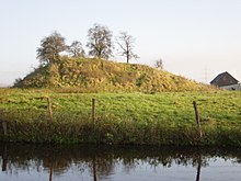
The Motte Altenburg is a former castle of the Jülich counts, probably from the 12th century. Today a tree-lined mound of earth can still be seen as a prominent elevation and the remains of a moat.
Web links
Commons : Altenburg - Collection of Images

