
Nysterbach
| Nysterbach / Baaler Bach | ||
 Nyster or Baaler Bach in the marshland between Baal and Lövenich |
||
| Data | ||
| Water code | DE : 28256 | |
| location | Germany | |
| River system | Rhine | |
| Drain over | Rur → Maas → Hollands Diep → North Sea | |
| River basin district | Meuse | |
| source | in Katzem 51 ° 1 ′ 56 ″ N , 6 ° 21 ′ 14 ″ E |
|
| Source height | 87 m above sea level NN | |
| muzzle | north of Hilfarth in the Rur Coordinates: 51 ° 2 ′ 35 ″ N , 6 ° 13 ′ 27 ″ E 51 ° 2 ′ 35 ″ N , 6 ° 13 ′ 27 ″ E |
|
| Mouth height | 47 m above sea level NN | |
| Height difference | 40 m | |
| Bottom slope | 3.7 ‰ | |
| length | 10.8 km | |
| Catchment area | 50.636 km² | |
| Drain at the mouth |
MNQ MQ |
45.17 l / s 271.87 l / s |

The Nysterbach ( also called Baaler Bach or Mühlenbach in Baal ) is a ten kilometer long watercourse / drainage ditch and a right side tributary of the Rur in the southern urban area of Erkelenz and Hückelhoven . Due to the lowering of the groundwater in the Garzweiler opencast mine , the former brook carries water extremely rarely and only from around the lower Baal area.
geography
course
The Nysterbach originally rises in the Erkelenz district of Katzem . From there, the straightened stream runs parallel to a bicycle path below Kleinbouslar . Between Katzem and Lövenich there is a former sewage treatment plant and a larger rainwater retention basin on the Hötzelenberg. In Lövenich, the moat disappears in a sewer pipe directly on the Gasberg and only appears in short sections in the village. At the end of the village there is a water treatment plant and a water inlet. Nonetheless, the stream in the wooded area of the rupture between Baal and Lövenich only carries water again in the lower area of the former Ophover mill and below the Haberger Hof . Here it meanders through a swampy forest valley. As the Baaler Bach it then flows through the center of Baal and the Rurauen between Gut Gansbroich , the Groß- and Kleinkünkel estates, and along Gut Grittern near Doverhahn towards Hückelhoven. Before the Hilfarther Bridge it finally flows into the Rur.
Tributaries
- Inflow from Helenenhof ( right ), 1.4 km
- Tee ditch from Lövenicher Graben ( left ), 1.3 km
- Doverener Bach ( right ), 4.3 km
Mills
In Baal the brook drove z. In some cases, several watermills remained on until the middle of the 20th century . While Ophover Mühle at Ophover Hof can only be seen from earlier mill ponds and the oil mill at the old train station was demolished in 1950, the buildings of the Mittelmühle in the center and the Pletschmühle on the western edge of the village still exist.
Others
The mostly dry moat has at least an identity-giving function as the namesake for the Nysterbach school and the folk theater association "Nysterbachbühne" in Lövenich, as well as for the Mühlenbach school in Baal.
photos
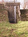
High water level between Katzem and Lövenich
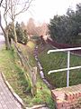
open stream section in Lövenich
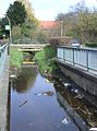
Stream course in Baal behind the Mittelmühle
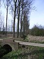
Baaler Bach near Gut Gansbroich


literature
- Werner Reinartz: Nysterbach and Baaler Bach. In: home calendar of the Erkelenzer Lande 1962, p. 132