
Rothenbach (Rur)
|
Rothenbach upper course: Helpensteiner Bach Dutch name: Rode Beek |
||
 Rothenbach at the Gitstapper mill |
||
| Data | ||
| Water code | EN : 28298 | |
| location |
Lower Rhine lowlands
|
|
| River system | Rhine | |
| Drain over | Rur → Maas → Hollands Diep → North Sea | |
| River basin district | Meuse | |
| source | of the Helpensteiner Bach on Friedrich-List - Allee in Wegberg - Wildenrath near the Siemens test center 51 ° 8 ′ 55 ″ N , 6 ° 9 ′ 47 ″ E |
|
| Source height | 55 m above sea level NN | |
| muzzle | in the Rur in Vlodrop Netherlands Coordinates: 51 ° 7 ′ 49 " N , 6 ° 5 ′ 11" E 51 ° 7 ′ 49 " N , 6 ° 5 ′ 11" E |
|
| Mouth height | approx. 28 m above sea level NN | |
| Height difference | approx. 27 m | |
| Bottom slope | approx. 1.7 ‰ | |
| length | 16 km with Helpensteiner Bach approx. 9.9 km without Helpensteiner Bach |
|
| Catchment area | 26.179 km² | |
| Drain at the mouth |
MNQ MQ |
99.33 l / s 175.39 l / s |
The Rothenbach is a brook over 14 kilometers long in the district of Heinsberg in the administrative district of Cologne in North Rhine-Westphalia and in the Dutch province of Limburg , which flows into the Rur from the right in the village of Vlodrop in the municipality of Roerdalen . Its upper course is the Helpensteiner Bach . His Dutch name is Rode Beek .
History and etymology

The Rothenbach is on a section of the border river between Germany and the Netherlands . The course of the border was determined at the Congress of Vienna . It says:
"... the former dominion of Dalenbrook, east of the city of Roermond , with the villages of Melick , Herkenbosch and Vlodrop of the former Jülich office of Wassenberg are being relocated to Holland ."
The Rothenbach was declared the natural border from Effeld to Dalheimer Mühle . At the Dalheimer Klostermühle the boundary stone 376 was set as a boundary point .
The Helpensteiner Bach is named after the Lords of Helpenstein; they owned a castle in Dalheim-Rödgen and operated a water mill at the Helpenstein pond .
geography
course
Helpensteiner Bach
The Rothenbach rises as Helpensteiner Bach from a source at 84 m above sea level. NN in Wegberg - Wildenrath an der Friedrich-List - Allee near the Siemens test center and then runs first in a northerly direction. On today's Helpensteinstrasse, he fed on the Helpenstein pond, which is now largely silted up ; in the 14th or 15th century, the Lords of Arsbeck built the Helpensteiner mill on this site . Then it flows through the Rödgener Weiher , also known as the Rakyweiher , near Dalheim-Rödgen , where its water drove the Rödgener Mühle via an overshot mill wheel until 1899 . Its further course leads in a westerly direction through a wooded area and finally into the mill pond of the listed Dalheimer Mühle, which also serves as a rainwater retention basin . The building work required for this was initiated and carried out by the German authorities. From the Dalheimer Mühle, the Helpensteiner Bach flows on as Rothenbach and border waters.
Rothenbach

The Rothenbach is the border water between Germany and the Netherlands on the route from the Dalheimer Mühle to the Effelder Waldsee. At the beginning, the Dutch authorities operate a sand trap . Both construction measures, rain retention basin and sand trap near the Dalheimer Mühle, were carried out in coordination with the responsible authorities in both countries. The course of the stream leads from here in a westerly direction past the Dutch town of Rothenbach to Vlodrop , where it feeds the Gitstapper mill . Because the Rothenbach meanders and constantly changes its bed, there are always slight changes in the area at this “living border”; she's walking in a corridor here . From the Effelder Waldsee, the Rothenbach flows over into Dutch territory and flows into Vlodrop at 28 m above sea level. NN from the right and as its northernmost tributary Rode Beek into the Rur .
Tributaries
- Krebsbach ( right ), 0.9 km
Jurisdiction and entertainment
Three authorities are responsible for the care and maintenance of the waters of Helpensteiner Bach and Rothenbach :
- Helpensteiner Bach , from the source to the Dalheimer Mühle: Stadt Wegberg.
- Rothenbach - German side , from the Dalheimer Mühle to the Effelder Waldsee, town of Wassenberg.
- Rothenbach - Dutch side ( "Rode Beek" ), from the Dalheimer Mühle to the confluence with the Rur in Vlodrop: Association Waterschap Roer en Overmaas
Watermills
- at the Helpensteiner Bach:
- Helpensteiner Mühle in Wegberg - Arsbeck , Heinsberg district
- Rödgener Mühle in Wegberg- Rödgen
- Dalheimer Mühle in Wegberg- Dalheim
- at Rothenbach:
- Gitstapper mill in Roerdalen - Vlodrop , Limburg province , Netherlands
- Vlodrop Mill in Roerdalen - Vlodrop , Limburg Province , The Netherlands
Tributaries
- Inflow to the Helpensteiner Bach, 0.848 kilometers
- Krebsbach , 0.747 kilometers
gallery
- Pictures from the Helpensteiner Bach
The Helpensteiner Bach
Former Helpenstein pond

The Helpenstein pond on the Tranchot map 1805/1807

The Rödgener Burgweiher
The Rödgener mill

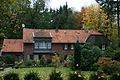
Dalheimer Mill

Dalheimer Mill


- Pictures from the Rothenbach

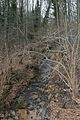
From the Dalheimer Mühle the Helpensteiner Bach becomes the Rothenbach

The Rothenbach
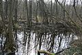
The mill pond at the Gitstapper mill

The mill wheel and the Rothenbach

Grinding in the Gitstapper mill

Gitstapper mill

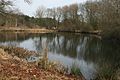
The Rothenbach just before the mouth in Vlodrop

Mouth of the Rothenbach into the Rur with a fish ladder


literature
- Hans Vogt: Lower Rhine water mill guide 2nd edition. Niederrhein Association, Krefeld 1998, ISBN 3-00-002906-0 , pages 409-410.
- Edmund Knorr: On the history of the German-Dutch border between Rothenbach and Boschbeeke home calendar of the Erkelenzer Lande, page 95-104
Web links
- Nature reserve Helpensteiner Bachtal, Schaagbachtal and Petersholz In: grenspark-msn.nl (German)
- Nature reserve "HS-005 Helpensteiner Bachtal, upper Schaagbachtal and Petersholz" in the specialist information system of the State Office for Nature, Environment and Consumer Protection in North Rhine-Westphalia
- Nature reserves in the Meinweg National Park In: npr-meinweg.eu (German)
- Picture of the Dalheimer mill in Wegberg and its description according to the monument authority. (German)