
Gitstapper mill
| Gitstapper mill
|
||
|---|---|---|
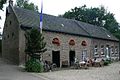
 Gitstapper mill in Vlodrop NL |
||
| Location and history | ||
|
||
| Coordinates | 51 ° 8 '16 " N , 6 ° 6' 31" E | |
| Location |
|
|
| Waters | Rothenbach | |
| Built | Documented mention in 1377 | |
| Shut down | 1918 (mill operation) | |
| Status | 1988 Show and museum mill | |
| technology | ||
| use | Grain and Oil Mill | |
| Grinder | 1 grind 1 oil mill | |
| drive | Watermill | |
| water wheel | Wooden wheel, medium-sized | |

The Gitstapper mill is a water mill with a medium-sized water wheel .
geography
The Gitstapper Mühle is located on Gitstappermolenweg in Vlodrop in the municipality of Roerdalen in the Dutch province of Limburg . The mill building is on the right side of the Rothenbach. Upstream of the mill is a mill pond, the water level of which is 33 m above sea level. NN lies. The Dalheimer Mühle , the Rödgener Mühle (1803–1899) and the Helpensteiner Mühle (14th / 16th centuries) are located above the Gitstapper Mühle .
Waters
The Rothenbach has its origin in the Helpensteiner Bach, which has its source near the Siemens test center on Friedrich-List-Allee. The source height is 84 above sea level. NN. The Helpensteiner Bach flows through the Rödgener Burgweiher, also called Rakyweiher, and supplied the Dalheimer Mühle with water via an overshot mill wheel until 1899. The further course of the brook leads through a wooded area to Dalheimer Mühle, where the Helpensteiner Bach flows through the upstream mill pond and forms the border between the Netherlands and Germany behind the mill as Rothenbach over a stretch of 5.5 km . On its way, the Gitstapper mill is supplied with water before the Rothenbach near Vlodrop on Dutch territory flows into the Rur as "Rode Beek" . The mouth height is 28 m above sea level. NN.
history
The Gitstapper mill was first mentioned in 1377 and belonged to the Lord of Vlodrop. The freedoms in Wassenberger Land benefited the Gitstapper Mühle, because the Gitstapper Müller from Geldrischen was allowed to fetch his grinding grain unhindered on the Jülich side. The current mill building was erected in 1750 as a stone building. The mill was operated as a grinding and oil mill . At the beginning of the 20th century the mill was in poor condition, so that in 1918 the oil mill was stopped. In 1987 the municipality bought the building, placed it under monument protection (Rijksmonument No. 37867) and restored the mill and the building. The property was reopened in 1988 as a show and museum mill with two functions as a water and electric mill.
gallery
Mill building

Mill wheel of the Gitstapper mill

Gitstapper Mill's grain mill

The royal wheel of the Gitstapper mill

Kitchen chamber of the Gitstapper mill

Mill chamber in the Gitstapper mill

Showroom in the Gitstapper mill


literature
- Peter Geuskens: The history of the Gitstapper mill up to the year 1800 Home calendar of the district of Heinsberg, 2013, ISBN 978-3-925620-34-8 , page 57-64
- Lower Rhine water mills - guide by Hans Vogt
- The Schwalm - Valley of the Mills by Horst Jungblut - Helmut Elstner
- Home book of the city of Wegberg - Compiled by Heinz Cohnen
- Wegberg cultural guide
Web links
- Stadtmarketing Wegberg (Ed.): Discover Wegberg in the valley of the 24 mills . 2013 ( wegbergermuehlen-leudalmolens.eu [PDF; 2.0 MB ; accessed on February 13, 2016]).
- Mill tour