
Dalheimer Mill
| Dalheimer Mill
|
||
|---|---|---|
 Dalheimer Mühle in Wegberg-Dalheim |
||
| Location and history | ||
|
||
| Coordinates | 51 ° 8 '55 " N , 6 ° 9' 48" E | |
| Location |
|
|
| Waters | Helpensteiner Bach, then Rothenbach | |
| Built | 1231 sales deed | |
| Shut down | 1958 (mill operation) | |
| Status | Restaurant and monument no.34 | |
| technology | ||
| use | Grain and Oil Mill | |
| Grinder | 1 grind 1 oil mill | |
| drive | Watermill | |
| water wheel | Wooden wheel, undershot | |
| Website | Website of the Dalheimer Mühle | |

The Dalheimer Mühle is a water mill with an undershot water wheel in Wegberg-Dalheim.
geography
The Dalheimer Mühle is located on Mühlenstraße in the Dalheim district in the Mittelstadt Wegberg in the Heinsberg district . The mill building is on the left side of the Rothenbach. In front of the mill is a mill pond, the water level of which is 55 m above sea level. NN and which is fed by the Helpensteiner Bach. Above the Dalheimer Mühle is the Rödgener Mühle, below the Gitstapper Mühle on Dutch territory.
Waters
The Rothenbach has its origin in the Helpensteiner Bach, which has its source near the Siemens test center on Friedrich-List-Allee. The source height is 84 m above sea level. NN . The Helpensteiner Bach flows through the Rödgener Burgweiher, also called Rakyweiher, on its way and supplied the Rödgener Mühle with water through an overshot mill wheel until 1899. The further course of the brook leads through a wooded area to Dalheimer Mühle, where the Helpensteiner Bach flows through the upstream mill pond and forms the border between the Netherlands and Germany behind the mill as Rothenbach over a stretch of 5.5 kilometers . On its way, the Gitstapper mill is supplied with water before the Rothenbach near Vlodrop flows into the Rur as "Rode Beek" in the Netherlands . The mouth height is 28 m above sea level. NN .
history
The history of the Dalheimer Mühle begins with a sales deed from 1231. In it, Heinrich Herr zu Helpenstein sells the mill, the pond and some of the land to the Cistercians in Ophoven . The mill forms the basis for the relocation of the monastery to Dalheim, which took place in 1258. The present mill building was rebuilt after a fire in 1775. The mill had a milling operation and oil press . With the abolition of the monastery in 1802 by the French government, the mill came into private hands. Around 1880 a restaurant was added to the mill building. In 1974 the mill was equipped with a new mill wheel. Milling was stopped in 1958. In 1998 the Dalheimer mill was almost completely destroyed by a fire. After eight years of construction, the Dalheimer Mühle was reopened in July 2008.
monument
Long rectangular structure with the water wheel on the north gable wall; two-storey; on the upper floor tapped half-timbering, partly boarded up; above the mill entrance Wappenstein dated "1775"; roof hipped over the living area; to the restaurant from a new era. (no inventory as a memorial). Addendum from April 24, 1990: Associated, single-storey brick building at the rear, subsequently plastered, with a gable roof, as a former bakery. (List of monuments No. 34)
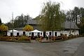
Dalheimer Mühle restaurant
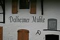
Lettering Dalheimer Mühle

Mill wheel of the Dalheimer mill

Coat of arms on the Dalheimer mill

Gear transmission from Dalheimer Mühle
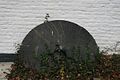
Millstone of the Dalheimer mill

Grain mill of the Dalheimer Mühle


literature
- Lower Rhine water mills - guide by Hans Vogt
- The Schwalm - Valley of the Mills by Horst Jungblut - Helmut Elstner
- Home book of the city of Wegberg - Compiled by Heinz Cohnen
- Wegberg cultural guide
Web links
- Website of the Dalheimer Mühle
- Stadtmarketing Wegberg (Ed.): Discover Wegberg in the valley of the 24 mills . 2013 ( wegbergermuehlen-leudalmolens.eu [PDF; 2.0 MB ; accessed on February 13, 2016]).
- Mill tour
Individual evidence
- ↑ http://www.rp-online.de/niederrhein-sued/kreis-heinsberg/nachrichten/im-gastraum-wuchsen-die-baeume-1.688795
At the worm :
Beeretz mill |
Bommers Mill |
Frelenberger Mill |
Horriger Mill |
Hünshovener oil mill |
Grinder and Oil Mill Trips |
Marienthaler Mill |
Müllendorfer mill |
Lohmühle |
Lohmühle |
Eichenthal Mill |
Mill Hommerschen |
Oil and paper mill Oberbruch |
Porselener Mill |
Randerather oil mill |
Rimburg mills |
Süggerather mill |
Interrupt mill |
Full mill interruption |
Zweibrügger Mühle
An der Junge Wurm:
Aldenhover Mühle |
Brünkers Mill |
Dahlmühle |
Horster mill |
Karker Mill |
Kemper Mill |
Lambertz Mill |
Liecker mill |
Powder mill ] |
Schafhausen grain mill |
Schafhausen oil mill |
Town mill |
Valley mill |
Wolfhager Mühle
Am Rodebach :
Brommler Mühle |
Dahlmühle |
Angel Mill |
Etzenrather mill |
Ingentaler Mill |
Isenbruch Mill |
Istrater mill |
Tüddern grain mill |
Millener mills |
Mohrenmühle |
Square mill |
Vollmühle Tüddern |
Wehrer Mühle
An der Schwalm :
Bischofsmühle |
Post mill |
Kornmühle Tüschenbroich |
Kringsmühle |
Lohmühle |
Neumühle |
Oil mill Tüschenbroich |
Rossmühle |
Wegberger Mühle
Am Mühlenbach :
Buschmühle |
Holtmühle |
Meismühle |
Molz mill |
Schrofmühle
Am Helpensteiner Bach:
Dalheimer Mühle |
Helpensteiner Mill |
Rödgener Mühle
Am Beeckbach :
Ophover Mühle
Am Kitschbach :
Kitscher Mühle
Am Knippertzbach :
Knippertzmühle
Am Uebach :
Übacher Mühle