
Millener mills
| Millener mills
|
||
|---|---|---|
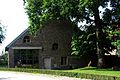
 Millener mill in Selfkant-Millen |
||
| Location and history | ||
|
||
| Coordinates | 51 ° 1 '30 " N , 5 ° 52' 36" E | |
| Location |
Germany
|
|
| Waters | Rodebach | |
| Built | 12./13. century | |
| Shut down | 1960 cessation of milling operations | |
| technology | ||
| use | Oil and grain mill | |
| Grinder | 2 grinding courses 1 oil press | |
| drive | Watermill | |
| water wheel | undershot | |
| Website | Millen site site | |

The Millener Mühlen are two watermills with an undershot water wheel located on the Rodebach in Selfkant , a rural municipality in the North Rhine-Westphalian district of Heinsberg .
geography
The Millener mills are located on the right and left side of the Rodebach in the Millen district in the Selfkant municipality. Since the stream forms the German-Dutch border, the left-hand mill is in the Netherlands . The terrain on which the mill buildings are located have a height of approx. 40 m above sea level. Neighboring mills are above the Tüddern grain mill and below the Isenbrucher mill .
Waters
Up until the last century, the Rodebach supplied fourteen mills with water. The stream begins at a retention basin near Siepenbusch in the town of Übach-Palenberg at an altitude of 105 m above sea level. The Rodebach has a length of 28.9 km to its confluence with the Geleenbeek near Oud-Roosteren in the Netherlands . The mouth height is 29 m above sea level. The care and maintenance of the Rodebach and its tributaries is subject to the respective neighboring cities and communities. → See also Rodebach
history
Millen's origin was the castle of a noble family. In 1118 a Heribert von Millen was mentioned for the first time as a follower of the Count von Geldern . In the 13th century Millen passed to Heinsberg , which in turn fell to the Duke of Jülich through marriage in the 15th century . This made it the administrative seat of the office of the same name. In 1536 a "Hilger Molner" on this side and "Hermann Molner" from the "other syde" are reported. So back then there were already two mills. One mill was a grain mill , the other an oil mill , before both finally only ground grain. Despite the constitutional separation, the mills remained an economic unit until they were closed at the end of the 1960s. The turbine last used drove both mills via a transmission . After the closure, the German mill was sold, while the Dutch mill remained with the castle. Both mills are under monument protection .
gallery
Millener Mill on the Dutch side

Rodebach at the Millener mills

Tranchot card 1804/05


Monument entry
Year of construction approx. 1800, white brick mill building with hipped roof , eaves cornice with block frieze , two to three axes , two-storey, windows on the upper floor with round arches and on the ground floor partially with wooden block frames, round arched gate entrance and main entrance with wooden frames.
List of monuments Selfkant No. 31, entry: March 27, 1985
literature
- Hans Vogt: Lower Rhine water mill guide 2nd edition. Verein Niederrhein, Krefeld 1998, ISBN 3-00-002906-0 , pp. 254-256.
- Wilhelm Pieper: The last mill wheel on the Rodebach home calendar 1995 Heinsberg district p. 158–164
- State survey office of North Rhine-Westphalia topographic map 1:50 000 L 5102 Geilenkirchen and L 5000 Selfkant, ISBN 3-89439-417-X
Web links
- Website of the Rodebach Landscape Park (German, Dutch)
- Website of the municipality of Selfkant
- Millen site site
At the worm :
Beeretz mill |
Bommers Mill |
Frelenberger Mill |
Horriger Mill |
Hünshovener oil mill |
Grinder and Oil Mill Trips |
Marienthaler Mill |
Müllendorfer mill |
Lohmühle |
Lohmühle |
Eichenthal Mill |
Mill Hommerschen |
Oil and paper mill Oberbruch |
Porselener Mill |
Randerather oil mill |
Rimburg mills |
Süggerather mill |
Interrupt mill |
Full mill interruption |
Zweibrügger Mühle
An der Junge Wurm:
Aldenhover Mühle |
Brünkers Mill |
Dahlmühle |
Horster mill |
Karker Mill |
Kemper Mill |
Lambertz Mill |
Liecker mill |
Powder mill ] |
Schafhausen grain mill |
Schafhausen oil mill |
Town mill |
Valley mill |
Wolfhager Mühle
Am Rodebach :
Brommler Mühle |
Dahlmühle |
Angel Mill |
Etzenrather mill |
Ingentaler Mill |
Isenbruch Mill |
Istrater mill |
Tüddern grain mill |
Millener mills |
Mohrenmühle |
Square mill |
Vollmühle Tüddern |
Wehrer Mühle
An der Schwalm :
Bischofsmühle |
Post mill |
Kornmühle Tüschenbroich |
Kringsmühle |
Lohmühle |
Neumühle |
Oil mill Tüschenbroich |
Rossmühle |
Wegberger Mühle
Am Mühlenbach :
Buschmühle |
Holtmühle |
Meismühle |
Molz mill |
Schrofmühle
Am Helpensteiner Bach:
Dalheimer Mühle |
Helpensteiner Mill |
Rödgener Mühle
Am Beeckbach :
Ophover Mühle
Am Kitschbach :
Kitscher Mühle
Am Knippertzbach :
Knippertzmühle
Am Uebach :
Übacher Mühle