
Beeckbach
| Beeckbach | ||
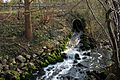
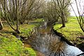
 The mouth of the Beeckbach (left) into the Schwalm |
||
| Data | ||
| Water code | EN : 2842 | |
| location | District of Heinsberg , North Rhine-Westphalia , Germany | |
| River system | Rhine | |
| Drain over | Schwalm → Maas → Hollands Diep → North Sea | |
| River basin district | Meuse | |
| source | Beginning of the stream in Erkelenz - Oerath 51 ° 5 ′ 31 ″ N , 6 ° 17 ′ 58 ″ E |
|
| Source height | 87 m above sea level NN | |
| muzzle |
Schwalmaue car park in Wegberg Coordinates: 51 ° 8 ′ 33 ″ N , 6 ° 16 ′ 33 ″ E 51 ° 8 ′ 33 ″ N , 6 ° 16 ′ 33 ″ E |
|
| Mouth height | approx. 64 m above sea level NN | |
| Height difference | approx. 23 m | |
| Bottom slope | approx. 2.5 ‰ | |
| length | 9.1 km | |
| Catchment area | 20.978 km² | |
The Beeckbach is a right tributary of the Schwalm in the North Rhine-Westphalian district of Heinsberg , in the administrative district of Cologne .
history
The Beeckbach, which originally had its sources in Moorshoven , was extended in 1928 at the request of the city of Erkelenz as an artificially dug stream up to the sewage treatment plant in Erkelenz. Constantly growing population , increasing industrialization and higher water consumption made an expansion of the Beeckbach urgently necessary. In addition, when the snowmelt and heavy rain, some towns were repeatedly threatened by floods and sometimes flooded. The stream takes in treated wastewater from the Erkelenz sewage treatment plant and surface water from Erkelenz, as well as partly from the south-eastern part of the city of Wegberg , and diverts it in the direction of Schwalm to Wegberg. The natural springs of the Beeckbach near the fire station in Moorshoven were filled in in 1906.
description
The Beeckbach with a length of 9.154 kilometers begins in Erkelenz- Oerath at an altitude of 87 m above sea level. NN . There it picks up the surface water and guides it through an open ditch system towards the Erkelenz sewage treatment plant. Here the brook absorbs the sewage water and diverts it in a northeasterly direction. After about a kilometer, the Beeckbach flows together with the Ziegelweiherfließ. This 1.7 kilometer long and partly piped body of water diverts the surface water of the city of Erkelenz from the Ziegelweiher and the northeastern new development areas in Erkelenz into the Beeckbach. After the confluence of the two bodies of water, the Beeckbach flows through the Isengraben rainwater retention basin built in 1983 . The rest of the way runs in a north-easterly direction between Isengraben and Rath-Anhoven , along the industrial area and then north-west to Schönhausen . The Beeckbach flows around parts of Schönhausen then flows past Bissen near Beeck and Moorshoven and through the rain retention basin at the Grenzlandring . After crossing under Landesstraße 400, the stream runs a short distance through Beeck , past Haus Beeck and Gerichhausen . Between Beeck and Gerichhausen, the Beeckbach takes on the Grunzbach, which drains the surface water from Uevekoven . At the Ophover mill, the Beeckbach flows through the mill pond and then finds its way through Wegberg to the mouth . At the Schwalmaue the Beeckbach flows at a height of 64 m above sea level. NN in the Schwalm.
gallery

Sewage treatment plant in Erkelenz
Clarified water flows into the Beeckbach
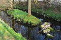
The Beeckbach in the renatured area

Water inlet from the Ziegelweiher flow
Beeckbach and Ziegelweiherfließ unite

The Beeckbach on the way through the rain retention basin
Natural design of the rain retention basin

Level measuring system in the rain retention basin


Rainwater retention basin and renaturation
The Beeckbach had reached the capacity limit in the 1980s and 1990s. Agricultural areas were constantly inundated and even localities along the Beeckbach were not spared from flooding. The Schwalmverband, as the responsible body, agreed a concept with the Cologne district government and the neighboring municipalities to tackle the expansion of the Beeckbach with simultaneous renaturation .
The first construction project in 1986 was the expansion of the line from the sewage treatment plant in Erkelenz to Rath-Anhoven. This included the expansion of a rainwater retention basin near the town of Isengraben. This was the first step. In the second construction phase, the retention basin was built on the Grenzlandring . In the third construction phase, the 3.5-kilometer stretch from Rath-Anhoven to Moorshoven was expanded. This brought the longed-for relief especially for Schönhausen. The partially piped route within the locality was removed. The Beeckbach was led around and through the local situation in a natural way and after the completion of the measures presented a wonderfully meandering course. Thus the towns of Rath-Anhoven, Schönhausen, Moorshoven and Bissen bei Beeck were rid of the great worry of flooding. For Schönhausen, the Beeckbach expansion means an improvement in the village environment and an enrichment for the village.
maintenance
The care and maintenance of the Beeckbach is the responsibility of the Schwalm Association, which is based in Brüggen .
Tributaries
- Ziegelweiher flow from the city center of Erkelenz, with a length of 1.7 kilometers
- Grunzgraben directs surface water from Uevekoven into the Beeckbach with a length of 1.1 kilometers
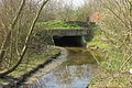
Mill on the Beeckbach
Ophover mill with existing mill equipment
gallery
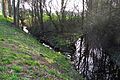
The renatured Beeckbach

Open brook can also be straight

Expansion of water bodies - an important protection against flooding

The Beeckbach in nature
Natural bridges on the Beeckbach

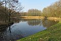
Ophover mill with pond that is fed by the Beeckbach

Winter impression at the Beeckbach

Winter at the Beeckbach 1990


literature
- Hans Vogt: Lower Rhine water mill guide 2nd edition. Verein Niederrhein, Krefeld 1998, ISBN 3-00-002906-0 , pages 425, 429.
- Wegberg cultural guide page 103
Web links
Individual evidence
- ↑ a b German basic map 1: 5000
- ↑ Topographical Information Management, Cologne District Government, Department GEObasis NRW ( Notes )
- ↑ Area directory for the water stationing map of the state of North Rhine-Westphalia ( Memento from October 17, 2013 in the Internet Archive ) (PDF; 556 kB)
- ↑ http://www.schwalmverband.de/
- ↑ Inn and monument no. 142 Wegberg